
Bute, St Michael's Chapel


Burial Ground (Medieval), Chapel (Medieval), Cist (Post Medieval)(Possible)
Site Name Bute, St Michael's Chapel
Classification Burial Ground (Medieval), Chapel (Medieval), Cist (Post Medieval)(Possible)
Alternative Name(s) Kilmichael
Canmore ID 39902
Site Number NR97SE 3
NGR NR 99240 70579
Datum OSGB36 - NGR
Permalink http://canmore.org.uk/site/39902


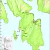
- Council Argyll And Bute
- Parish North Bute
- Former Region Strathclyde
- Former District Argyll And Bute
- Former County Buteshire
NR97SE 3 9924 7058
(NR 9922 7056) St Michael's Chapel (NR) (In Ruins)
OS 6" map, (1924)
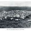
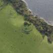
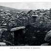
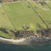
St Michael's Chapel (Scott et al 1915-61) called Kilmichael by Hewison, is roofless, built of smooth stones from the beach mixed with earth. The rectangular building, oriented E-W, measures some 25 1/2ft by 18 1/2ft over 6ft thick walls, standing about 6ft high. A 2ft 6ins wide doorway is in the N wall. A rough slab, apparently the altar, is in situ in the E end. The curves on the W gable suggest that the roof was of beehive type, but the presence of a few thick slates, pierced for pins, lying on the floor, opposes this at first, However, there is no record of services being held here in Protestant times, and the chapel may have been repaired with slates for a ward-house. The burial ground, still in use, is surrounded by a roughly circular wall, 84ft and 78ft in diameter.
Hewison suggests that as the period in which churches were dedicated to St Michael is so much later than the date of this building, the dedication may be to St Maccaile, a pupil of St Patrick, who died in 490 (?St Maughold).
Sources: J K Hewison 1893; H Scott et al 1915-61.
Field Visit (19 October 1976)
NR 9924 7059 St Michael's Chapel (name confirmed) is generally as described in the previous information. It measures internally 5.7m E-W by 3.8m transversely. The walls survive to a height of 2.0m but there are no longer any remains of the gables. The burial ground is no longer in use, the last burial having been in 1927.
Surveyed at 1:10,000.
Visited by OS (B S) 19 October 1976.
Ground Survey (October 2007)
NR 9924 7058 We undertook a formal survey to stone-bystone level of detail of the ruined chapel, a simple rectangular building with a single entrance to the N during October 2007. Thick-walled clay-bonded structure built entirely of local schist without dressings. The curvature of the sides of the W gable wall perhaps suggests an early Christian date; some evidence for localised rebuilding of the collapsing wall remains. The interior had evidently been partly cleared out before the late 19th century.
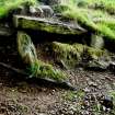
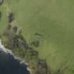
A general survey of the graveyard and its perimeter wall was completed. To the E and NE the wall is sited upon a broad, low bank that may represent the remains of a much earlier boundary structure. To the NW, as the ground begins to slope steeply down, stonework at the surface may represent further parts of the early boundary - possible wall core. To the SW, where the existing wall has been breached, grazing animals have caused substantial erosion; a number of graves are partly exposed including a substantially built cist burial. The inscriptions of later monuments were recorded.
Archive deposited with Bute Museum, RCAHMS., Mount Stuart Archive.
Funder: Discover Bute Landscape Partnership Scheme; partners - HLF; SNH; The Mount Stuart Trust, Highlands and Islands Enterprise, Argyll and Bute Council; Buteshire Natural History Society; Bute Community Council.
Fabric Recording (August 2009 - July 2010)
NR 99240 70579 A programme of works was undertaken in August 2009 and March and July 2010 at St Michael’s Chapel as part of a four year programme to consolidate the scheduled ancient monuments on Bute. The planned consolidation forms part of a wider programme of landscape enhancement facilitated by the DBLPS.
Consolidation works were undertaken in three main phases. The replenishment of the clay bonding of the chapel walls and repairs to the soft topping of the walls, the repair of the surrounding boundary wall and the consolidation of eroding areas on the SW slope of the site.
The record for the site was enhanced by the production of a plan of the archaeological remains that were actively eroding from sections on the SW side of the chapel enclosure. This recording, which complimented earlier archaeological recording undertaken by Addyman et al in 2007, was achieved with the assistance of community volunteers, and formed part of a wider programme providing archaeological training opportunities for members of the local community.
Archive: Bute Museum and RCAHMS
Funder: Historic Scotland, Heritage Lottery Fund and Argyll and Bute Council
Paul Duffy – Discover Bute Landscape Partnership Scheme
Field Visit (19 May 2009)
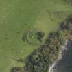
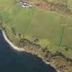
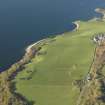
This chapel and the graveyard in which it stands are situated on a low, natural knoll on the leading edge of a W-facing terrace 270m SW of Kilmichael farmsteading. The E flank of the knoll slopes gently onto the flat of the terrace, but the W flank falls onto the steep face of the terrace, and here the graveyard wall, which elsewhere follows the foot of the knoll, takes the form of a revetment 1.2m in height. The ruinous chapel is as previously described. A cist (NS 99242 70557) is visible on the S side of the graveyard, where a section of the wall has collapsed and the knoll is badly eroded. Orientated NE and SW, it measures at least 1.6m in length by 0.9m in width and 0.45m in height within a capstone and side-slabs.
A low rubble mound, which may be a tinker's grave (J Herriot pers. comm.), is situated by the entrance in the N side of the chapel. The chapel, which is depicted on Mackinlay's map of 1823, is shown unroofed on the 1st edition of the OS 6-inch map (Argyllshire and Buteshire 1869, Sheet CXCIII).
Visited by RCAHMS (GFG, PM) 19 May 2009.

