Accessibility

Font Size

100% 150% 200%

Background Colour

Default Contrast
Close Reset

Measured Survey

Date 1983 - 1987

Event ID 554016

Category Recording

Type Measured Survey

Permalink http://canmore.org.uk/event/554016

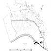
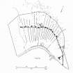
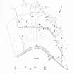
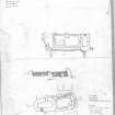
A survey of the main areas of historic settlement on St Kilda was carried out by the Commission in 1983-6 at the invitation of the National Trust for Scotland.

People and Organisations

Digital Images

Publication drawing; St Kilda village, distribution plan of houses dating from 1861 and later. Photographic copy.
Publication drawing; St Kilda village, distribution plan of houses dating from 1861 and later. Photographic copy.Publication drawing; St Kilda, Village: distribution plan of estate and community buildings. Photographic copy.Publication drawing; St Kilda village, distribution plan of remains identifiable from Sharbay survey. Photographic copy.
Publication drawing; St Kilda, Village: distribution plan of buildings built or remodelled since 1886. 
Publication drawing; St Kilda, Village: distribution plan of outlying enclosures and dykes.Publication drawing; St Kilda, village, distribution plan of early structures.St Kilda, Village Bay. Survey drawings of (1) House 8 and Blackhouse I, and (2) Blackhouse E. 
St Kilda, Village Bay. Plane-table survey, sheet 2.St Kilda, Village Bay. Plane-table survey, sheet 3.St Kilda, Village Bay. Plane-table survey, sheet 4.St Kilda, Village Bay. Plane-table survey, sheet 5.St Kilda, Village Bay. Plane-table survey, sheet 7.
St Kilda, Village Bay. Plane-table survey, sheet 8.St Kilda, Village Bay. Plane-table survey, sheet 9.St Kilda, Village Bay. Plane-table survey, sheet 10.St Kilda, Village Bay. Plane-table survey, sheet 11.St Kilda, Village Bay. Plane-table survey, sheet 12.
Publication drawing; inked plan of St Kilda Village.

References