RCAHMS National Archaeological Survey, Special Surveys


Date 1997 - 1998
Event ID 1112441
Category Project
Type Project
Permalink http://canmore.org.uk/event/1112441
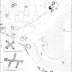
Two special surveys were carried out this year on behalf of Historic Scotland. The first was at Strone Hill, Angus, undertaken to provide a plan of the area in advance of an evaluation of the damage inflicted by rabbits, while the other was of the possible Neolithic long mound at Herald Hill, near Meikleour in south-east Perthshire.
The landscape at the west end of Strone Hill is typical of many of those hitherto encountered in north-east Perthshire. Within an area of about 16.4 ha (approximately 36 acres) there is a host of archaeological features relating to its use from prehistory to the Improvement period. The prehistoric remains range from burial-cairns and ring-cairns to no less than twenty-two hut-circles, some of them of with double walls (cf: North-east Perth: an archaeological landscape); surrounding the cairns and hut-circles there is a complex field system comprising small cairns, lynchets and linear clearance heaps, some of which appear to delineate fields. The pre-Improvement landscape contains a linear settlement of rectangular buildings and enclosures strung out along the fragmentary remains of an old head dyke, just above the limits of the modem arable fields. Two enigmatic stone-built features, one known as 'The Abbot's Cross', were surveyed in greater detail; both may relate to the boundaries of the lands held by Arbroath Abbey in the Middle Ages.
The survey of Herald Hill was of a rather different character, aimed at providing a detailed contour plan and Digital Terrain Model of the mound. Although most of the work was carried out by EDM, the Global Positioning System was also tested, successfully, for the collection of this type of data.
RCAHMS Annual Report 1997-8, 20-21