
Pricing Change
New pricing for orders of material from this site will come into place shortly. Charges for supply of digital images, digitisation on demand, prints and licensing will be altered.
Lochmaben Castle


Castle (Medieval)
Site Name Lochmaben Castle
Classification Castle (Medieval)
Alternative Name(s) Castle Loch; Peel Of Lochmaben
Canmore ID 66315
Site Number NY08SE 8
NGR NY 0883 8115
Datum OSGB36 - NGR
Permalink http://canmore.org.uk/site/66315


First 100 images shown. See the Collections panel (below) for a link to all digital images.
- Council Dumfries And Galloway
- Parish Lochmaben
- Former Region Dumfries And Galloway
- Former District Annandale And Eskdale
- Former County Dumfries-shire
NY08SE 8 0883 8115.
(NY 0883 8115) Lochmaben Castle (NR) (Remains of)
OS 6" map (1957)
For predecessor motte (NY 0820 8220), see NY08SE 7.
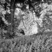
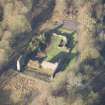
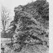
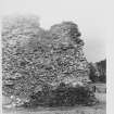
The surviving stonework of this castle, which was not maintained after the Union of the Crowns in 1603 is 15th century. The ramparts and ditches are older and must be identified with the timber pele of Edward I, built 1298-9.
A bank and ditch, having no function in the plan of the castle, set slightly in front of the outer ward and a more extended rampart which runs from the loch to Valison Burn, Radford suggests may define a Roman-period meeting place, the 'locus Maponi' of the Ravenna Cosmography, although this is commonly located at the Lochmaben Stone (NY36NW 4).
Medieval finds are in Dunfries Museum and the Mational Museum, Edinburgh.
C A R Radford 1954; E Birley 1954; J MacQueen 1954; R C Reid 1954; I A Richmond and O G S Crawford 1949; RCAHMS 1920; I A Richmond 1958
As described above. Surveyed at 1/2500. No accession numbers could be obtained for the finds in Dumfries Museum.
Visited by OS (EGC) 20 June 1966
The stone castle at Lochmaben is first mentioned in 1365, 1367 and 1375, when its construction is recorded, but the timber peel (presumably NY08SE 7) was still maintained. It became a royal castle (under the administration of James II) in 1445, and was used as a campaigning base (by James V) in 1542, It appears to have fallen out of use in the later 17th century, and was subsequently quarried for stone, being ruinous by the end of the 18th century (when it was drawn by Adam de Cardonnel).
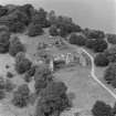
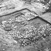
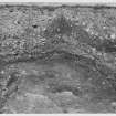
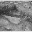
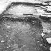
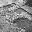
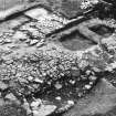
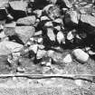
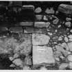
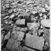
In 1968-72 small-scale area excavation was carried out within the outer ward (area A) and in the SW angle of the outer plateau or bailey (area B); the counterweight pit to the gateway was excavated in the former area, and evidence of Victorian and later consolidation and landscaping was widespread. The excavated finds comprise mainly pottery, with some iron- and bronze- work, but little bone.
The remains of three constructional phases were recognised in area A; all were attributed to the same building operation within a short period in the later 14th century. The excavation of area B aimed to establish the date and character of the earthwork defences; several post-holes were found but no pattern was recognised. The platform that comprises the bailey was found to have been built-up with clay, while the probable palisade-trench that was set behind the lip of ditch A was dated to shortly after 1300. Pottery from the brown earth deposit above the clay appeared consistent with a late 14th century date, and that area had apparently formed a 'work camp' during the construction of the castle. Lead-smelting hearths were identified, while quantities of iron slag and pot wasters were found. The S sector of the bailey was apparently abandoned after the stone castle was built.
A D S Macdonald and L R Laing 1977
The finds from Macdonald and Laing's excavations are held in Dumfries Museum under accession number DUMFM: 1977.6.
Information from Mrs S Ratchford (Dumfries Museum), 7 November 1994.
NY 0883 8115 A watching brief was undertaken in January and February 2001 during clearance operations within one of a series of defensive ditches positioned S of the castle. This is one of two ditches which have been used by the adjacent farm as general purpose refuse dumps.
The task was to remove all recent infill dumping. The hope was that the sides of the ditch could be re-established and that the archaeological deposits believed to have accumulated in the lower parts of the ditch would be left undisturbed.
The potential problems with this operation lay both in the dumped farm material to be removed which could range from the mundane to the toxic, as well as the nebulous nature of the ditch itself, almost all of which was now invisible thanks to landscaping. Removal of the overburden from the archaeological layers within the ditch exposed them to drying and weathering. It was noted that the ditch is not naturally level and that drainage would take place in both an easterly and westerly direction.
Sponsor: Historic Scotland.
G Ewart and P Sharman 1996.
Scheduled as Lochmaben Peel and Castle.
Information from Historic Scotland, scheduling document dated 26 February 2003.
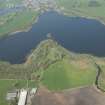
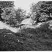
NY 082 820 to NY 082 818 Oval enclosure, 150m by up to 70m, identified adjoining the SSE side of the Old Motte of Lochmaben (NY08SE 7), coaxial to the longer axis of the motte and containing Gallows Hill. Houses and gardens overlie where it would join. The enclosure is contained by a bank, ditch and counterscarp bank, now only recognisable on the NE and SW, otherwise reduced to a scarp and terrace, and obscured by golf course earthworks on the NW. It clearly functioned as a very large bailey, and might therefore be Edward I's palisade or cloisture outside the peel constructed in 1299, although this has normally been identified with the site occupied by the later castle (NY08SE 8).
The ditch on the NE, around the base of Gallows Hill, can be traced for 120m, 8-12m wide, and the remains of the counterscarp bank, up to 20m thick, along the escarpment overlooking Castle Loch. Beyond a D-shaped mound, 40 x 30m, which projects from the slope, the defences continue as a scarp and terrace along the slope crest. The southern end, in the next field, E of Castlehill Farm, has been almost obliterated by ploughing, but the course is resumed in the SW corner of the Gallows Hill field at NY 081 818, where the bank, ditch and counterscarp are extant for 70m, before merging with the farm road.
T C Welsh 2004
NY08SE 8 0883 8115
EXTERNAL REFERENCE:
SCOTTISH RECORD OFFICE
Royal letter concerning repair of Lochmaben Castle. Sent to Earl of Mar, treasurer, and Sir Archibald Naper, Treasurer Depute.
1624 GD 124/10/270
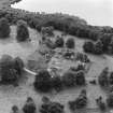
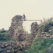
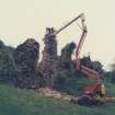
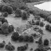
Aerial Photography (1971)
Oblique aerial photographs of Lochmaben Castle, Dumfries and Galloway, showing excavation in progress. Photographed by John Dewar in 1971.
Publication Account (1980)
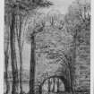
Lochmaben was a castle which belonged to the Bruces of Annandale and later to the Earls of Douglas until their forfeiture in 1440. Thereafter it was crown property and was allowed to decay irretrievably. An amount of confusion exists as to the particular site in question: the later stone built castle however, may be taken to be later than 1300.
The initial Norman fortif1cation was built in the early twelfth century as a residence for the Bruce family who were granted Annandale by David I, 1124-1153. The site of this structure was undoubtedly the Castle Hill motte which today serves as the fourteenth tee at the municipal golf course. It is known that Edward I shortly after his victory at Falkirk in 1298 caused to be built 'an enclosure outside the castrum, made strong by a pallisade' (RCAM, 1920, 151), but it is unclear where that structure was built. Some local scholars are of the opinion that Edward built his pele on the iron age site at the south end of Castle Loch, thus abandoning the Norman motte (Reid, 1952-53, 60-1) yet others (Wilson, 1973 9; Anon, n.d.,8) believe that the Edwardian pele was built at the motte.
The fortunes of Lochmaben castle - whatever its site - seesawed back and forth between warring English and Scottish factions. In 1385 Scottish forces under the conmand of Archibald Douglas, Lord of Galloway, after a nine day siege razed the castle to the ground (Reid, 1952-53, 73), thus ending years of English domination. The castle came into full possession of the Douglases until their forfeiture in 1440, when it reverted to the crown. It remained crown property and after the Union of the Crowns in 1603 it was allowed to decay.
Information from ‘Historic Lochmaben: The Archaeological Implications of Development’ (1980).
Publication Account (1986)
The earliest Bruce castle is a motte which now does service as the 14th tee on the golf-course south-west of the town. Its summit is unusually large and oval on plan, and is partly surrounded by a ditch. Artefacts recovered from the site are in Nithsdale District Museum, Dumfries.
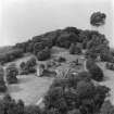
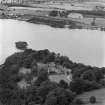
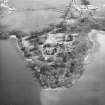
It was superseded in the later 13th or 14th century by the stone castle which occupies a promontory at the southern end of Castle Loch, a stretch of water that has always been renowned for its fish. Immediately to the south of the castle, an earthen platform marks the position of a moated and timber-palisaded enclosure (a peel) built by Edward I of England in 1298. Peel and stone castle were protected by outer ditches and ramparts.
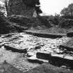
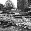
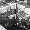
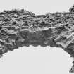
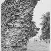
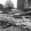
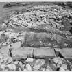
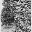
The most remarkable feature of the stone castle is a 6.1m wide canal which fronts the south curtain-wall. The canal is spanned by tall wing-walls which are arched, probably to accommodate boats when the level of the loch was higher. Some curtain-walls survive almost to their original heights, but are mainly reduced to rubble core; ashlar masonry can be seen around the edges of the canal. The counterweight pit for a drawbridge is clearly visible in the centre of the south wall. This gateway was backed by a passage running beneath what was possibly a gatehouse and great hall range, of which only the foundations now survive.
From 1298 until the Union of Crowns in 1603 Lochmaben was of vital strategic importance in the ebb and flow of Anglo-Scottish warfare. For much of the 14th century it was in English hands, and in 1373-6 extensive repairs and additions were made. It was eventually surrendered to the Scots under the Earl of Douglas in 1384 and became a royal castle, King James IV later residing here from time to time. During his reign a great hall was built, and the castle was later described as 'the king's own house and of the greatest strength of any in this west border of Scotland'. From 1524 until 1588 keepership was vested in the Lords Maxwell, but the castle suffered because of their feud with the Johnstones and their Catholic sympathies. Although steps were taken to maintain the castle in 1624-5, its days as a garrisoned military stronghold had effectively passed in 1603.
Information from ‘Exploring Scotland’s Heritage: Dumfries and Galloway’, (1986).
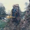
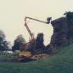
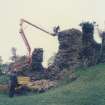
Watching Brief (15 October 1996 - 17 October 1996)
Eight holes on either side of the W wing wall were monitored by Kirkdale Archaeology in advance of the erection of supporting scaffolding. All trenches revealed deposits associated with the decay of adjacent masonry, and the gradual infilling of the moat or canal in front of the mid-14th-century stone castle. In some of the holes there was possible evidence for the denuded earthen bank defining the moat or canal, sealed by bone-rich occupation debris.
Kirkdale Archaeology
Sponsor: HS
G Ewart, P Sharman 1996; DES 1996, p 31
Note (1997)
NY 0883 8115 NY08SE 8
Listed as castle, medieval pottery and coins.
RCAHMS 1997.
Watching Brief (24 January 2001 - 14 February 2001)
NY 0883 8115 A watching brief was undertaken in January and February 2001 during clearance operations within one of a series of defensive ditches positioned S of the castle. This is one of two ditches which have been used by the adjacent farm as general purpose refuse dumps.
The task was to remove all recent infill dumping. The hope was that the sides of the ditch could be re-established and that the archaeological deposits believed to have accumulated in the lower parts of the ditch would be left undisturbed.
The potential problems with this operation lay both in the dumped farm material to be removed which could range from the mundane to the toxic, as well as the nebulous nature of the ditch itself, almost all of which was now invisible thanks to landscaping. Removal of the overburden from the archaeological layers within the ditch exposed them to drying and weathering. It was noted that the ditch is not naturally level and that drainage would take place in both an easterly and westerly direction.
Sponsor: Historic Scotland.
G Ewart and P Sharman 2001
Kirkdale Archaeology
Watching Brief (25 November 2008)
NY 0883 8118 and NY 0883 8112 Four small holes were excavated for the installation of new gates in the perimeter fence of Lochmaben Castle on 25 November 2008. No features or finds of archaeological significance other than fragments of stone, possibly evidence of stone robbing, were recorded.
Archive: RCAHMS (intended)
Funder: Historic Scotland
David Murray – Kirkdale Archaeology
Project (12 September 2016 - 16 September 2016)
NY 0883 8115 A programme of geophysical survey was undertaken, 12–16 September 2016, at Lochmaben Castle which aimed to answer research questions. A combination of gradiometer, resistance and ground penetrating radar (GPR) surveys was undertaken. Gradiometer and resistance surveys were carried out over available areas within the Properties in Care (PIC) boundary and available areas of the Peel, to the S of the castle. GPR survey was undertaken within the available areas in the PIC boundary and available areas to the N of the PIC boundary and E of the Peel. Individual GPR transects were also collected across the Peel and in the wooded area to the SW of the Peel, where vegetation cover precluded a larger GPR survey.
Within the PIC area a well-defined high resistance anomaly to the N of the extant castle has been detected, although this may indicate a modern path. Other anomalies, suggestive of potential structural remains, have been detected within the castle. However, the anomalies appear to largely correspond with earthworks and, as such, their exact geophysical origin in unclear. The GPR survey of this area, which was detecting to a greater depth than the resistance survey, has recorded several anomalies of potential interest between 1m and 2m below the current ground surface and on a different alignment to the castle.
Within the area of the Peel broad areas of high resistance have been detected. While the majority of these are somewhat amorphous and likely to have a natural origin, some more discrete anomalies closer to the castle have been noted. There is broad correlation with the gradiometer results which suggest possible well-defined areas of activity just to the S of the castle entrance and respecting a likely trackway leading to the drawbridge. Selected GPR transects across the anomalies detected by the resistance survey, broadly support this interpretation.
Archive: Rose Geophysical Consultants
Funder: Historic Environment Scotland
Susan Ovenden – Rose Geophysical Consultants
(Source: DES, Volume 17)
Ground Penetrating Radar (12 September 2016 - 16 September 2016)
NY 0883 8115 Ground penetrating survey.
Archive: Rose Geophysical Consultants
Funder: Historic Environment Scotland
Susan Ovenden – Rose Geophysical Consultants
(Source: DES, Volume 17)
Resistivity (12 September 2016 - 16 September 2016)
NY 0883 8115 Resistivity survey.
Archive: Rose Geophysical Consultants
Funder: Historic Environment Scotland
Susan Ovenden – Rose Geophysical Consultants
(Source: DES, Volume 17)
Magnetometry (12 September 2016 - 16 September 2016)
NY 0883 8115 Magnetometry survey.
Archive: Rose Geophysical Consultants
Funder: Historic Environment Scotland
Susan Ovenden – Rose Geophysical Consultants
(Source: DES, Volume 17)
Archaeological Evaluation (23 July 2018 - 5 August 2018)
NY 088 811 A trial trenching evaluation was carried out, 23 July – 5 August 2018, at Lochmaben Castle. The work aimed to shed new light on the castle's development and the nature of its occupation, as well as providing an opportunity for local community engagement.
There was evidence across the site for the possible landscaping which occurred for Queen Victoria’s Jubilee and this may have negatively affected any underlying medieval archaeology. The only potentially significant features were a possible medieval ditch within Trench 4 and a stone culvert in Trench 3. No definite interpretations could be made due to the size of trenches and time constraints.
Archive: NRHE (intended). Report: Dumfries and Galloway HER
Funder: Historic Environment Scotland
Leah Watt – CFA Archaeology Ltd
Mortar Analysis
NY 0883 8115 A survey of Lochmaben Castle identified large volumes of constructional mortar materials eroding from various ex situ blocks of masonry tumble adjacent to the upstanding walls of the building complex. These materials have been subject to a programme of recording, sampling and lab-based analysis as a prelude to wider landscape, buildings and materials analysis at the site.
Archive: NRHE (intended)
Funder: University of Stirling and Historic Environment Scotland
Mark Thacker – University of Stirling
(Source: DES Vol 19)
OASIS ID: cfaarcha1-325220

