Pricing Change
New pricing for orders of material from this site will come into place shortly. Charges for supply of digital images, digitisation on demand, prints and licensing will be altered.
Old Bridge Of Urr
Road Bridge (16th Century)
Site Name Old Bridge Of Urr
Classification Road Bridge (16th Century)
Alternative Name(s) River Urr; Urr Water
Canmore ID 64567
Site Number NX76NE 16
NGR NX 77593 67714
Datum OSGB36 - NGR
Permalink http://canmore.org.uk/site/64567
- Council Dumfries And Galloway
- Parish Crossmichael
- Former Region Dumfries And Galloway
- Former District Stewartry
- Former County Kirkcudbrightshire
NX76NE 16 77593 67714
Old Bridge of Urr [NAT]
OS 1:10,000 map, 1978.
For adjacent Dubbisdale Mill, see NX76NE 26.
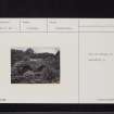
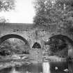
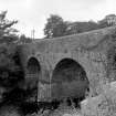
(NX 7760 6771). 'The Old Bridge of Urr' traditionally bore the date '1580' on one of the two heraldic panels on the south side. Originally about 9ft 8ins [2.95m] wide, the bridge was widened on the north side, probably in 1843 when the parapets were built.
RCAHMS 1914.
This bridge is generally as described by the RCAHMS. The two heraldic panels are still visible though no date can now be deciphered. The name is still known and used locally.
Visited by OS (RD) 29 July 1968.
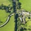
(Location cited as NX 775 677). Old Bridge of Urr: an interesting two-arched bridge with centre buttress over the River Urr near the old meal mill (NX76NE 25). Dates from the late 18th century.
I Donnachie 1971.
(Location cited as NX 776 677). Old Bridge of Urr, late 18th century. Two-span rubble bridge with semicircular arches and triangular cutwaters.
J R Hume 1976.
This bridge carries an unclassified public road across the Urr Water or River Urr, which here forms the boundary between the parishes of Crossmichael (to the SW) and Kirkpatrick-Durham (to the NE).
Information from RCAHMS (RJCM), 28 October 2005.


