
Following the launch of trove.scot in February 2025 we are now planning the retiral of some of our webservices. Canmore will be switched off on 24th June 2025. Information about the closure can be found on the HES website: Retiral of HES web services | Historic Environment Scotland
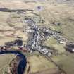
St John's Town Of Dalry, Motte


Motte (Medieval)
Site Name St John's Town Of Dalry, Motte
Classification Motte (Medieval)
Canmore ID 64314
Site Number NX68SW 5
NGR NX 61888 81262
Datum OSGB36 - NGR
Permalink http://canmore.org.uk/site/64314


- Council Dumfries And Galloway
- Parish Dalry (Stewartry)
- Former Region Dumfries And Galloway
- Former District Stewartry
- Former County Kirkcudbrightshire
NX68SW 5 61888 81262
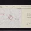
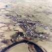
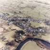
(NX 6188 8126) Dalry Mote (NR).
OS 6" map (1957)
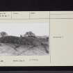
This motte (R W Feachem 1956) is situated on slightly sloping ground on top of the E bank of the Water of Ken. Its slightly irregular summit measures 112ft N-S by 102ft transversely; it is highest in the NW; 25ft, while on the S it is 15ft high. The base has been encircled by a ditch, 23ft wide on the side farthest from the river, narrowing to 10ft as it curves towards the river bank. Along the S it has been interfered with by the formation of a road, and on the ESE it appears to have been filled in, or has been left unexcavated, for a distance of 45ft.
RCAHMS 1914, visited 1911; F R Coles 1892
The motte is in a commanding position above the Water of Ken. The steep sides are enclosed by a silted ditch; this has a maximum depth of 0.5m and has been effaced on the east and south by dumping and by a trackway. The summit area is 38.0m NE-SW by 31.0m; it has been disturbed, probably as a result of stone robbing, but possible stances can be identified on the south-west and east sides. The approach to the top was most probably on the east side. There is no evidence of a bailey.
Surveyed at 1:2500.
Visited by OS (TRG) 16 February 1978

