
St John's Town Of Dalry, Motte


Motte (Medieval)
Site Name St John's Town Of Dalry, Motte
Classification Motte (Medieval)
Canmore ID 64314
Site Number NX68SW 5
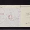
NGR NX 61888 81262
Datum OSGB36 - NGR
Permalink http://canmore.org.uk/site/64314


- Council Dumfries And Galloway
- Parish Dalry (Stewartry)
- Former Region Dumfries And Galloway
- Former District Stewartry
- Former County Kirkcudbrightshire
NX68SW 5 61888 81262
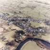
(NX 6188 8126) Dalry Mote (NR).
OS 6" map (1957)
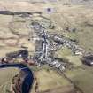
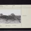
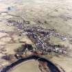
This motte (R W Feachem 1956) is situated on slightly sloping ground on top of the E bank of the Water of Ken. Its slightly irregular summit measures 112ft N-S by 102ft transversely; it is highest in the NW; 25ft, while on the S it is 15ft high. The base has been encircled by a ditch, 23ft wide on the side farthest from the river, narrowing to 10ft as it curves towards the river bank. Along the S it has been interfered with by the formation of a road, and on the ESE it appears to have been filled in, or has been left unexcavated, for a distance of 45ft.
RCAHMS 1914, visited 1911; F R Coles 1892
The motte is in a commanding position above the Water of Ken. The steep sides are enclosed by a silted ditch; this has a maximum depth of 0.5m and has been effaced on the east and south by dumping and by a trackway. The summit area is 38.0m NE-SW by 31.0m; it has been disturbed, probably as a result of stone robbing, but possible stances can be identified on the south-west and east sides. The approach to the top was most probably on the east side. There is no evidence of a bailey.
Surveyed at 1:2500.
Visited by OS (TRG) 16 February 1978

