|
Manuscripts |
MS 726/1 |
Records of CFA Archaeology Ltd, archaeologists, Musselburgh, East Lothian, Scotland |
Rapid survey of archaeological sites within the Stewartry of Kirkcudbright Environmentally Sensitive Area |
1991 |
Item Level |
|
|
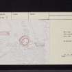
Prints and Drawings |
DC 25610 CO |
|
Distribution map of archaeological sites within the Stewartry Environmentally Sensitive Area, mapsheet NX68SW |
1991 |
Item Level |
|
|
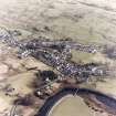
Photographs and Off-line Digital Images |
C 25196 CN |
RCAHMS Aerial Photography |
Oblique aerial view centred on town from W. |
1994 |
Item Level |
|
|
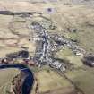
Photographs and Off-line Digital Images |
C 25197 CN |
RCAHMS Aerial Photography |
Oblique aerial view centred on town from W. |
1994 |
Item Level |
|
|
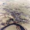
Photographs and Off-line Digital Images |
C 25198 CN |
RCAHMS Aerial Photography |
Oblique aerial view centred on town from WSW. |
1994 |
Item Level |
|
|
Prints and Drawings |
DC 3514 |
|
Plan of site and section AA. |
13/6/1979 |
Item Level |
|
 |
On-line Digital Images |
SC 1671177 |
RCAHMS Aerial Photography |
Oblique aerial view centred on town from W. |
1994 |
Item Level |
|
 |
On-line Digital Images |
SC 1671178 |
RCAHMS Aerial Photography |
Oblique aerial view centred on town from W. |
1994 |
Item Level |
|
 |
On-line Digital Images |
SC 1671179 |
RCAHMS Aerial Photography |
Oblique aerial view centred on town from WSW. |
1994 |
Item Level |
|
|
Photographs and Off-line Digital Images |
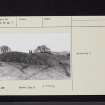
A 77756 |
Records of the Ordnance Survey, Southampton, Hampshire, England |
Motte. View from North. Dalry, Kirkcudbrightshire. |
1978 |
Item Level |
|
|
Photographs and Off-line Digital Images |
A 77757 |
Records of the Ordnance Survey, Southampton, Hampshire, England |
Motte. Dalry, Kirkcudbrightshire. |
1978 |
Item Level |
|
 |
On-line Digital Images |
SC 2466154 |
Records of the Ordnance Survey, Southampton, Hampshire, England |
St John's Town Of Dalry, Motte, NX68SW 5, Ordnance Survey index card, page number 1, Recto |
c. 1958 |
Item Level |
|
 |
On-line Digital Images |
SC 2466155 |
Records of the Ordnance Survey, Southampton, Hampshire, England |
St John's Town Of Dalry, Motte, NX68SW 5, Ordnance Survey index card, page number 2, Verso |
c. 1958 |
Item Level |
|
 |
On-line Digital Images |
SC 2466156 |
Records of the Ordnance Survey, Southampton, Hampshire, England |
St John's Town Of Dalry, Motte, NX68SW 5, Ordnance Survey index card, page number 1, Recto |
c. 1958 |
Item Level |
|
 |
On-line Digital Images |
SC 2466157 |
Records of the Ordnance Survey, Southampton, Hampshire, England |
St John's Town Of Dalry, Motte, NX68SW 5, Ordnance Survey index card, page number 2, Recto |
c. 1958 |
Item Level |
|
 |
On-line Digital Images |
SC 2466158 |
Records of the Ordnance Survey, Southampton, Hampshire, England |
St John's Town Of Dalry, Motte, NX68SW 5, Ordnance Survey index card, Recto |
c. 1958 |
Item Level |
|
|
All Other |
551 166/1/1 |
Records of the Ordnance Survey, Southampton, Hampshire, England |
Archaeological site card index ('495' cards) |
1947 |
Sub-Group Level |
|


