
Pricing Change
New pricing for orders of material from this site will come into place shortly. Charges for supply of digital images, digitisation on demand, prints and licensing will be altered.
Doon Wood


Fort (Period Unassigned)
Site Name Doon Wood
Classification Fort (Period Unassigned)
Canmore ID 63892
Site Number NX64NE 14
NGR NX 6574 4883
Datum OSGB36 - NGR
Permalink http://canmore.org.uk/site/63892


- Council Dumfries And Galloway
- Parish Twynholm
- Former Region Dumfries And Galloway
- Former District Stewartry
- Former County Kirkcudbrightshire
NX64NE 14 6574 4883.
(NX 6574 4883) Doon (NR)
OS &2 map (1957)
An enigmatic structure.
RCAHMS TS., 12 May 1952; F R Coles 1893
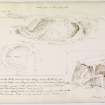
Situated within a plantation on Doon Hill is a horse-shoe shaped fort which terminates on a near precipitous slope to the S. It consists of a single earth and stone rampart with ditch and counterscarp bank enclosing an area measuring 52m NW-SE by 58m transversely. Within the rampart is a ditch formed by scarping the central raised area. There is no indication of a bank along the edge of the interior. The entrance is not clear but was probably in the SW. A break in the rampart in the W is not accompanied by a break in the counterscarp bank.
The name 'Doon' is still used locally.
Surveyed at 1:2500.
Visited by OS (JP) 5 February 1971.
Field Visit (29 September 1911)
472. 'Doon', Nun Mill
This fort is situated on the top of the steep-wooded bank which rises above the road from Kirkcudbright to Senwick, just to the westward of Nun Mill. From an elevation of some 90 feet above the low meadow, which intervenes between the bank and the foreshore, the fort commands the mouth of the Dee as the river opens into Kirkcudbright Bay. A system of two trenches and two mounds placed alternately and in horse-shoe form resting on the edge of the bank, has enclosed an area with a chord of some 179 feet and a radius at its greatest depth of 154 feet. On the east the defences have been considerably effaced, but elsewhere they are unusually well preserved. The inner scarp, which is sloped to an angle of some 40 degrees, varies in height up to 14 feet, while the trench from crest to crest measures from 30 to 40 feet in width; the inner mound is prominent and well -formed ; the outer trench has a width of 24 to 30 feet with a steep scarp as high as 8 feet, and a counterscarp of from 3 to 4 feet. Along the crest of the inner rampart are traceable the foundations of a narrow wall some 2 feet 6 inches in width, which has occupied the flat top. A broad gap through the inner rampart towards the west and a slight depression on the innermost scarp seems to indicate the position of the entrance. The ramparts are of earth and stone. See Antiquaries, xxvii. p.136 (plan).
Visited by RCAHMS 29th September 1911.
Field Visit (15 June 1951)
NS 657 478
Earthwork, 'The Doon', Nunmill (Inventory No. 472)
The plan given in Proceedings (xxvii, 136) is adequate and there is nothing to add to the Inventory description except that the site has been recently replanted with conifers. As is pointed out in Proceedings, this is an enigmatic structure and its date and affinities are uncertain
Visited by RCAHMS (KS) 15 June 1951
Field Visit (5 February 1971)
Situated within a plantation on Doon Hill is a horse-shoe shaped fort which terminates on a near precipitous slope to the S. It consists of a single earth and stone rampart with ditch and counterscarp bank enclosing an area measuring 52m NW-SE by 58m transversely. Within the rampart is a ditch formed by scarping the central raised area. There is no indication of a bank along the edge of the interior. The entrance is not clear but was probably in the SW. A break in the rampart in the W is not accompanied by a break in the counterscarp bank.
The name 'Doon' is still used locally.
Surveyed at 1:2500 (plan and section).
Visited by OS (JP) 5 February 1971.
Note (20 December 2013 - 23 May 2016)
This fort backs onto the coastal escarpment, which falls away steeply for some 30m to the western shore of the estuary of the River Dee. Slightly oval on plan, the interior measures a maximum of 58m from NE to SW by 52m transversely (0.23ha); though the evidence of an internal ditch cutting back into the slope to present a scarp up to 4.5m in height within the line of the main rampart may indicate that there is an inner line of defence along its crest enclosing a rather smaller interior. The main rampart, a bank of earth and stone, stands up to 2.4m above the bottom of an external ditch some 7m in breadth, and there is also a counterscarp rampart. The position of the entrance is not clear, but may be on the SW.
Information from An Atlas of Hillforts of Great Britain and Ireland – 23 May 2016. Atlas of Hillforts SC0245

