
Cauldside Burn


Stone Circle (Neolithic) - (Bronze Age)
Site Name Cauldside Burn
Classification Stone Circle (Neolithic) - (Bronze Age)
Canmore ID 63691
Site Number NX55NW 8
NGR NX 5295 5711
Datum OSGB36 - NGR
Permalink http://canmore.org.uk/site/63691


- Council Dumfries And Galloway
- Parish Anwoth
- Former Region Dumfries And Galloway
- Former District Stewartry
- Former County Kirkcudbrightshire
NX55NW 8 5295 5711
(NX 52955711) Stone Circle (NR)
OS 6" map (1957)
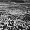
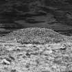
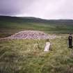
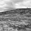
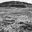
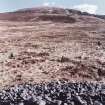
Immediately S of the cairn NX55NW 22, and with the nearest stone 16'6" from it, are the remains of a stone circle about 70' in diameter, of which ten stones remain in situ. These stones are thin slabs, set with their broad faces in the line of the circumference. The tallest stone is 4' high by 3' broad, but none of the others is more than 2' above the ground. The ground enclosed by the circle, and in its vicinity, has been much dug for turf or peat and many of the stones on the E semicircle have been removed.
Coles considers that this stone circle represents the remains of the kerb of a cairn, all its other stones having been robbed at some unknown date.
RCAHMS 1914, visited 1912; F R Coles 1895
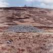
NX 5295 5712. The remains of a stone circle, approx 24.0m diameter, formed by eleven sandstone slabs (A, C-J, L and M on plan) and the stumps of three others (B, K and N on plan). A small loose granite stone (O on plan) also lies on the circle but this is probably fortuitous. The uneven interior which is covered by a thick layer of peat shows evidence of surface disturbance.
The even spacing of the slabs and the absence of stone in the interior indicates that this is the remains of a stone circle rather than the kerb of a cairn.
Surveyed at 1:10 000.
Visited by OS (TRG) 21 June 1977
Field Visit (5 July 1994)
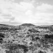
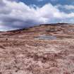
This peat-covered stone circle is situated in the saddle between Cambret Hill and Cairnharrow, and it lies immediately to the SSE of a large round cairn (NX55NW 22). Nine stones survive on the N and W arcs of the circle but only two others are visible on the remainder of the circumference; together, they define a circle about 25m in diameter. The largest surviving stone, which lies on the WSW, stands to a height of 1.2m and measures 0.8m by 0.2m at the base. The stones are all thin slabs, with their broad faces aligned on the circumference of the circle.
What may be an outlier to the circle lies some 100m to the NNE (NX 5298 5723); it comprises a flat slab protruding from the peat with its long axis orientated towards the centre of the circle (see also the stone setting at NX 5291 5722 (NX55NW 24)).
(Cree94 354)
Visited by RCAHMS (DCC) 5 July 1994

