
Marygoldhill Plantation


Fort (Prehistoric), Linear Earthwork (Prehistoric), Settlement (Prehistoric)
Site Name Marygoldhill Plantation
Classification Fort (Prehistoric), Linear Earthwork (Prehistoric), Settlement (Prehistoric)
Alternative Name(s) Marygold Plantation, Bunkle Edge
Canmore ID 59927
Site Number NT86SW 3
NGR NT 80737 60520
NGR Description Centre
Datum OSGB36 - NGR
Permalink http://canmore.org.uk/site/59927


- Council Scottish Borders, The
- Parish Bunkle And Preston
- Former Region Borders
- Former District Berwickshire
- Former County Berwickshire
NT86SW 3 8072 6051
(NT 8072 6051) Fort (NR) Ancient Track (NR) (Twice)
OS 6" map, Berwickshire, 2nd ed., (1908).
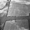
Fort and Settlement: This is a fort which has been re-used as an open settlement in the 2nd and succeeding centuries AD (R W Feachem 1963).
Visited by OS (JLD) 23 November 1954.
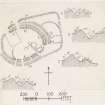
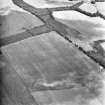
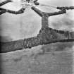
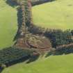
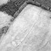
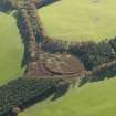
The fort, entirely overgrown, is oval on plan and measures 320ft by 255ft within twin stone ramparts and a medial ditch. The inner rampart stands from 3ft 8ins to 7ft above the interior and 8ft to 11ft above the bottom of the ditch. The elevation of the outer rampart is slight.
A sub-rectangular annexe adjoins the fort on the E. Several circular stone foundations and linear earthworks lie inside and outside the fort. The earthworks consist of a bank about 14ft wide and a ditch about 3ft wide and 4ft to 5ft deep. Dr Steer considers them to be old field banks.
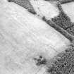
Some 150 yds E of the three-sided bank and ditch NW of the fort, and 50 yds from the wood to the SE is a single depression 10ft in diameter and 1ft 9ins deep, resembling a hut circle.
Nine sherds of local Late Iron Age pottery were recovered from the roots of a fallen tree within the fort by Dr Steer in 1950(Dr K Steer RCAHMS), who donated them to the NMAS (Accession No: HH 559).
RCAHMS 1915; J H Craw 1928; Proc Soc Antiq Scot 1952 (Donations).
The fort, settlement, and linear earthworks are generally as described by the previous authorities. The 'three-sided' bank and ditch NW of the fort appears to be too substantial for a field bank; its purpose, therefore, is uncertain.
The features shown as 'Ancient Tracks', however, are almost certainly field banks.
No trace of the hut circle mantioned above could be found.
Resurveyed at 1:2500.
Visited by OS (RD) 11 March 1966.
(NT 8072 6051) Fort and Settlement (NR)
OS 1:10,000 map, (1976).
This impressive fort, standing in dense undergrowth, is generally as described. The large annexe attached to its E side is presumably a subsequent development.
There is an extensive enclosure-system around the fort.
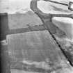
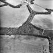
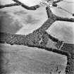
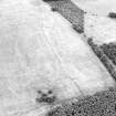
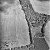
On the NW, NE and SW the fort is surrounded by three sides of a rectilinear earthwork (comprising two banks and a medial ditch), which encloses at least 8 hectares. From the W corner of the earthwork an irregular bank and ditch runs NW for 300m. Half-way along its course there is an entrance with staggered terminals, and to the N of the entrance the ditch is replaced by a series of quarry-pits. On the SW the rectilinear earthwork is approached by a linear earthwork, 100m of which has been preserved in a plantation (NT 804 604 to NT 802 601).
F Lynn 1897; RCAHMS 1915; RCAHMS 1980, visited 1979.
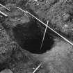
Excavation on this recently ploughed out site established that the line of the N-S bank and ditch predated the double rampart and ditch which surrounds the Marygoldhill plantation enclosure. This later ditch was found to be cut to a depth of 3m into the natural rock. Three circular 1m by 1m rock-cut pits and three sectors of the segmented rock-cut ditch which composed a continuous 30m length of the N-S monument were sectioned and excavated showing possible post-pipes within each of th e three pits.
P Strong 1984.
Scheduled [with NT86SW 4] as 'Marygold Plantation, forts 845m W and 730m NW of Marygold...'
Information from Historic Scotland, scheduling document dated 20 February 2009.
Field Visit (17 August 1908)
18. Fort, Marygold Hill Plantation.
A little more than ½ mile to the south-west of No. 17 [NT86SW 5] along the plantation on Marygold Hill, at an elevation of nearly 800 feet above sea-level, is situated another fort (fig. 5 [DP 225493]). It is, however, entirely overgrown with young fir-trees and brackens, and its features can only with difficulty he discerned. It appears to be an irregular oval measuring some 321 feet by 255 feet internally, surrounded, except towards the west where the rampart is single, by double ramparts, seemingly of stone, and is subtended on the east by an annex somewhat rectangular on plan. As shown on the sections, the inner rampart rises above the interior from 3 feet 8 inches to 7 feet, and above the bottom of the intervening trench from 8 to 11 feet. The elevation of the outer rampart is slight. There are indications of hut circles and other erections in the interior.
RCAHMS 1915, visited 17 August 1908.
See Ber. Nat. Club, 1894-95, p. 368 (plan and secs.); Christison, p.354.
OS Map: Ber., x. NE.
Field Visit (17 August 1908)
19. Defensive Enclosure, Drakemire.
Apparently in connection with the foregoing (No. 18 [NT86SW 3]), there are the remains of another enclosure extending from the wood into the Drakemire Moor on the north-west. It is contained on three sides, the south side being obliterated, by a mound and ditch about 19 feet across, the ditch in places being 4 to 5 feet deep and about 3 feet wide at bottom. The two short parallel straight sides measure some 250 feet and 300 feet respectively, and the curved side which joins them about 1500 feet. From the south-west corner of the enclosure an ancient track consisting of an irregular mound about 14 feet across, and a trench in places 3 feet below its crest, runs north-west in an irregular course across the moor. A similar, though less noticeable track, the mound and trench of which measure some 15 feet over all, crosses the plantation immediately to the south-west, and runs through the heather in a south-west direction for a distance of about 300 yards. Crossing the trench are numerous traverses about 9 feet apart. Some 150 yards east of the above enclosure, and 50 yards from the wood to the south-east, is a single depression 10 feet in diameter and 1 foot 9 inches deep, resembling a hut circle.
RCAHMS 1915, visited 17 August 1908.
See Ber. Nat. Club, 1894-95, p. 370 (plans and secs.); Antiquaries, xxix. p. 166; Christison, p. 354.
OS Map: Ber., x. NE.
Field Visit (30 August 1950)
This site was included within the RCAHMS Marginal Land Survey (1950-1962), an unpublished rescue project. Site descriptions, organised by county, are available to view online - see the searchable PDF in 'Digital Items'. These vary from short notes, to lengthy and full descriptions. Contemporary plane-table surveys and inked drawings, where available, can be viewed online in most cases - see 'Digital Images'. The original typecripts, notebooks and drawings can also be viewed in the RCAHMS search room.
Information from RCAHMS (GFG) 19 July 2013.
Measured Survey (1980)
RCAHMS surveyed the linear earthwork at Marygoldhill in 1980 following a field visit in February of that year (RCAHMS 1980b, No. 316), planning the linear earthwork at 1:1000 and the entrance at 1:200.
Desk Based Assessment (November 2011 - October 2012)
Cultural Heritage assessment for the proposed Monashee Wind Farm identifies all historic environment features within the development area through desk-based assessment and field survey. The nature of effects on these features is discussed.
Funder: RDS Element Power
CFA Arachaeology Ltd.
Note (15 February 2016 - 31 August 2016)
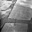
This fort is situated across a gentle slope dropping into the shoulder of a slight spur on the leading edge of Bunkle Edge above Marygold. The fort, which is almost certainly one of those depicted in 1771 on Andrew and Mostyn Armstrong's Map of the County of Berwick (1771), appears on the later map of The County of Berwick by T Sharp, Christopher Greenwood, and William Fowler of The County of Berwick (1826), but shortly after was planted with trees, thus escaping the attention of the OS surveyors who in 1857 annotated the large outlying enclosure on the NW as a camp. The latter, which was bulldozed in the early 1980s had a rock-cut ditch up to 3m deep (Strong 1988) and is one of a number of ditched enclosures found around forts in Berwickshire and East Lothian, though none has been dated and their relationships to the forts found within them are unknown. This is no less true at Marygoldhill Plantation, where the rectilinear enclosure measured 515m in length from NE to SW, with angles on the N and W, and enclosed at least 6ha upslope from the fort.
Now cleared of trees, the fort itself is oval on plan, measuring about 98m from NE to SW by 78m transversely (0.6ha) within twin ramparts with a medial ditch; the inner rampart stands between 1m and 2m above the level of the interior and up to 3m above the bottom of the broad ditch. There is a probable entrance on the WNW, where the E terminal turns slighlty inside the line of the W terminal, and probably a second on the opposite side of the interior on the ESE, though this sector has been mutilated by subsequent occupation and there are two gaps in the circuit here; another gap on the NNW is almost certainly relatively recent. The remains of the later occupation have two elements, namely a cluster of five stone-founded round-houses identified by James Hewat Craw on the ESE side of the interior, and an external rectilinear annexe on the NE, apparently springing from the counterscarp rampart adjacent to the western of the two gaps on this side, and returning on the NNW; though Francis Lynn's plan suggests it may have crossed in front of the entrance on the NW to mount the W terminal of the inner rampart. The interior of this annexe measures up to 90m across from NNW to SSE (0.3ha); it is subdivided by several banks and may also have contained several stone-founded round-houses
Information from An Atlas of Hillforts of Great Britain and Ireland – 31 August 2016. Atlas of Hillforts SC4104
Note (23 December 2019)
The location, classification and period of this site have been reviewed.
Excavation (2020)
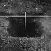
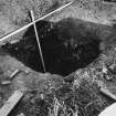
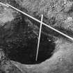
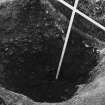
NT 8072 6051 Excavations were undertaken on the linear earthwork forming an enclosure close to Marygoldhill Plantation fort (Canmore ID: 59927). The enclosure is visible on the ground as a linear depression which partially encloses the fort, running for approximately 200m SE–NW, turning at a right angle to extend around 425m SW–NE and around 85m NW–SE. Entrances/breaks in the earthwork are suspected at its western end, on both the SE–NW and SW–NE stretches. The enclosure is generally considered to be an annexe of the nearby fort. Excavations were carried out at the site in 1983, following severe plough damage. The ditch was found to be V-shaped, 5m in width, with a bank measuring around 3m in width on the interior. Excavations were halted at 3m in depth, which appears to have been close to the lowest point of the ditch. The objectives of the current excavations were to explore the nature and condition of the earthworks with a view to gaining a better understanding of the form, function and date of the ditch.
A trench 9 x 2.5m and was placed across the ditch on an SW–NE alignment, close to the northern edge of the plantation. An extension around 2m and 1.5m wide was later added to the SW, to catch the edge of the outer bank.
The outer bank was found to be formed of a stony, mixed deposit surviving to a depth of around 0.2m which overlay a layer of weathered natural. Running along the exterior edge of the outer bank were the traces of a wall formed of rounded and sub-angular stones up to 0.25m in diameter, surviving only to one course. This is interpreted as a footing or low wall demarcating the extent of the outer bank.
The ditch was cut into the bedrock, with the upcast material being incorporated into the banks. The ditch fill was very stony, formed mostly of what appeared to be bank material that had slipped into the ditch. Despite the previous excavators having commented on how wet the ditch fill was, in this area the fill was well drained and appeared sterile; indeed, the soil samples collected did not yield any organic material suitable for dating.
Work was undertaken as part of Whiteadder: Historic Heart of the Lammermuirs, a community arts and archaeology project led by Scottish Borders Council in partnership with East Lothian Council, and delivered by AOC Archaeology Group and CMC Associates.
Archive:NRHE
Funder: Fallago Environment Fund and the Scottish Borders LEADER programme
Sbc Note
Visibility: This is an upstanding earthwork or monument.
Information from Scottish Borders Council

