
Pricing Change
New pricing for orders of material from this site will come into place shortly. Charges for supply of digital images, digitisation on demand, prints and licensing will be altered.
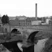
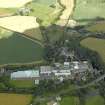
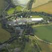
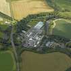
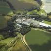
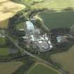
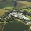
Chirnsidebridge, Paper Mill


Paper Mill (19th Century)
Site Name Chirnsidebridge, Paper Mill
Classification Paper Mill (19th Century)
Alternative Name(s) Chirnside Paper Mill; Broomhouse Paper Mill; Chirnside Bridge, Paper Mill And Stalk; Whiteadder Water
Canmore ID 94784
Site Number NT85NE 61
NGR NT 85119 56290
Datum OSGB36 - NGR
Permalink http://canmore.org.uk/site/94784


- Council Scottish Borders, The
- Parish Edrom
- Former Region Borders
- Former District Berwickshire
- Former County Berwickshire
NT85NE 61.00 85119 56290
NT85NE 61.01 NT 8502 5617 Mill Cottages
NT85NE 61.02 NT 85091 56211 Manager's House
NT85NE 61.03 NT 85065 56201 Summerhouse
NT85NE 61.04 NT 85123 56428 Filter Beds
NT85NE 61.05 NT 85092 56379 Bridge (Whiteadder Water)
NT85NE 61.06 Cancelled
NT85NE 61.07 NT 84767 56366 to NT 84802 56233 to NT 85022 56208 Lade
See also:
NT85NW 79 NT 84793 56388 Weir (Whiteadder Water)
For railway bridge (adjacent to N) over the Whiteadder Water, see NT85NE 86.
ARCHITECT: David Cousin, 1842.
The mill was partly demolished between 1971 and 1973.
(Undated) information in NMRS.
(Location cited as NT 853 561). Chirnside Paper Mill, founded 1842. A much-altered complex, with the original frontages retained. These are 2-storey and attic, with two centre-gabled blocks, one 9, the other 13 bay, the latter flanked by 3-bay gabled wings. There is a large circular brick chimney.
J R Hume 1976.
Sbc Note
Visibility: This is an upstanding building.
Information from Scottish Borders Council.

