
Pricing Change
New pricing for orders of material from this site will come into place shortly. Charges for supply of digital images, digitisation on demand, prints and licensing will be altered.
Hawick Railway Station


Footbridge (19th Century), Goods Shed (19th Century), Railway Station (19th Century)
Site Name Hawick Railway Station
Classification Footbridge (19th Century), Goods Shed (19th Century), Railway Station (19th Century)
Alternative Name(s) The Waverley Line; Edinburgh To Hawick Branch Railway; Border Union Railway
Canmore ID 88149
Site Number NT51NW 51.01
NGR NT 50514 15262
Datum OSGB36 - NGR
Permalink http://canmore.org.uk/site/88149


![Water crane [or column] at N end of down platform, Hawick railway station](http://i.rcahms.gov.uk/canmore/l/SC00429919.jpg)


![Water crane [or column] at N end of down platform, Hawick railway station](http://i.rcahms.gov.uk/canmore/s/SC00429919.jpg)


- Council Scottish Borders, The
- Parish Hawick
- Former Region Borders
- Former District Roxburgh
- Former County Roxburghshire
NT51NW 51.01 50514 15262
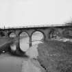
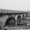
For Teviot Viaduct see NT51NW 92
Station closed 1969, demolished late 1970's, site now occupied by Waverley (Hawick) Leisure Centre.
Information from RCAHMS (DE) November 1995
NT 5050 1530. Nothing survives of the station buildings, platforms or goods yard in an area now landscaped and covered by a sports centre.
The site of the original Hawick Station of 1849 lay about 81m W of that constructed after the Carlisle extension was completed in 1862. The original station described in the Object Name Book of the Ordnance Survey (ONB) as 'A dwelling house for station master with offices, sheds and coal depots (NT 50437 15255), at the terminus of the Hawick Branch of the North British Railway' (Name Book 1858).
When the Carlisle extension was completed in 1862, a new station was constructed at the N end of the now demolished railway viaduct across the River Teviot. The 1st and 2nd editions of the OS 6-inch maps (Roxburghshire, 1863 and 1899, sheet xxv), depict the relative positions of the two stations. On the opening of the new station, the site of the original buildings were used as a goods depot.
The later station with covered footbridge closed in 1969 along with the rest of the Waverley Line and the buildings were completely removed when the Leisure Centre was built in the 1970s.
Visited by RCAHMS (DE), August 2006
NMRS REFERENCE:
Station opened 01/11/1849 and closed on 06/01/1969.
Sbc Note (21 March 2016)
Visibility: This was the site of an archaeological monument, which may no longer be visible.
Information from Scottish Borders Council
Previously also listed under duplicate site NT96SW 510 -CANCELLED. HES (LCK) 11.6.2024

