
Pricing Change
New pricing for orders of material from this site will come into place shortly. Charges for supply of digital images, digitisation on demand, prints and licensing will be altered.
Castlesteads


Pit Alignment (Prehistoric)
Site Name Castlesteads
Classification Pit Alignment (Prehistoric)
Alternative Name(s) Newton
Canmore ID 53483
Site Number NT36NW 53
NGR NT 33765 69520
NGR Description NT 3375 6926 to NT 3377 6977
Datum OSGB36 - NGR
Permalink http://canmore.org.uk/site/53483


- Council Midlothian
- Parish Newton
- Former Region Lothian
- Former District Midlothian
- Former County Midlothian
NT36NW 53 3375 6926 to 3377 6977
See also NT36NW 70.
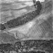
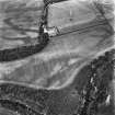
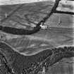
NT 337 692 to NT 337 698. Pit Alignment, Castlesteads: Aerial photography has revealed the crop marks of a pit alignment. It shows around 80 pits, 3m to 5m apart, in an approximately straight line. Nothing is visible on the ground.
Univ Edinburgh Extra-Mural Dept 1979
Scheduled as Newton, pit alignment.
Information from Historic Scotland, schedulinbg document dated 6 August 1993.
Aerial photographs show that the pit-alignment continues to the North of trees. See also NT36NW 70.
Information from RCAHMS (RHM) 16 November 1994.
NT 337 695. An excavation was carried out in October and November 1994 where one of a series of pit alignments recorded around Castle Steads was intersected by the proposed route of the A68 Dalkeith Northern Bypass. One large trench measuring c50m by 30m was excavated over the pit alignment, and three 4m wide runner trenches with a combined length of c290m were opened to examine adjacent land where cropmark traces of former cultivation had previously been identified.
Nine pits were recorded in the main trench, arranged in a single line and orientated on a N-S axis. These varied in size from 3.5-5.5m long and 2.2-2.8m wide and were mostly c1m deep. They do not appear to have held posts, and it appears unlikely that they were deliberately infilled. Putatively medieval pottery was recovered from the upper layers of four pits, and a chert flake came from the primary fill of a fifth. No trace of an adjacent bank was identified. To the E of one of the pits a cluster of seven smaller pits and post holes was identified, three of which contained large fragments of later prehistoric pottery. The eroded remains of rig-and-furrow cultivation systems were identified, representing a different, later pattern of land-use.
Sponsor: Roads Directorate of The Scottish Office Industry Department, managed on its behalf by Historic Scotland.
K J Cameron 1995.
Site identified during an archaeological assessement carried out by CFA Archaeology Ltd.
Mhairi Hastie, 2006.
Note (1988)
Castlesteads/Newton NT 33 69 NT36NW 52 & 53
Cropmarks between Newton House and Castlesteads reveal two lines of pits roughly parallel to each other about 300m apart. The E line runs N for a distance of 500m from a wood on the N bank of the River North Esk (NT 3374 6924) to the boundary between the districts of Midlothian and East Lothian (NT 3376 6973); the other runs from a field boundary 15Om ESE of Newton House (NT 3348 6979) to the district boundary (NT 3348 6992), a distance of about 250m. Both continue N of the district boundary forming part of a system of pit-alignments which covers an area of about 130ha.
RCAHMS 1988
(Halliday 1982, 76)
Aerial Photographic Transcription (3 August 1990 - 10 November 1990)
An aerial transcription was produced from oblique aerial photographs. Information from Historic Environment Scotland (BM) 31 March 2017.

