
Pricing Change
New pricing for orders of material from this site will come into place shortly. Charges for supply of digital images, digitisation on demand, prints and licensing will be altered.
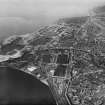
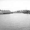
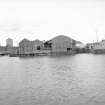
Edinburgh, Leith Docks, East Old Dock, Boatbuilding Yard And Dry Dock


Shipyard (Period Unassigned)
Site Name Edinburgh, Leith Docks, East Old Dock, Boatbuilding Yard And Dry Dock
Classification Shipyard (Period Unassigned)
Alternative Name(s) Water Of Leith
Canmore ID 222105
Site Number NT27NE 1007
NGR NT 27020 76750
NGR Description Centred NT 27020 76750
Datum OSGB36 - NGR
Permalink http://canmore.org.uk/site/222105


- Council Edinburgh, City Of
- Parish Edinburgh (Edinburgh, City Of)
- Former Region Lothian
- Former District City Of Edinburgh
- Former County Midlothian
NT27NE 1007.00 centred 27020 76750
Formerly entered as Engineering Works; location formerly cited as NT 2703 7676.
See also NT27NE 57.00 and NT27NE 57.41.
NT27NE 1007. 01 NT 27024 76767 Dry Dock
Boatbuilding Yard [NAT]
OS (GIS) ep. 4.
Engineering Works [NAT]
OS 1:1250 map, 1970.
This yard formerly fronted onto the Water of Leith. The current edition of the OS (GIS) AIB depicts the area as having been redeveloped. The dry dock had evidently been infilled by 1970, when the OS 1:1250 map depicts its area as open ground.
Information from RCAHMS (RJCM), 14 June 2006.

