
Pricing Change
New pricing for orders of material from this site will come into place shortly. Charges for supply of digital images, digitisation on demand, prints and licensing will be altered.
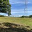
Bonnyside East


Signal Platform(S) (Roman)
Site Name Bonnyside East
Classification Signal Platform(S) (Roman)
Alternative Name(s) Antonine Wall; Bonnyside Expansions
Canmore ID 46801
Site Number NS87NW 4
NGR NS 8379 7980
NGR Description NS 8379 7980
Datum OSGB36 - NGR
Permalink http://canmore.org.uk/site/46801


- Council Falkirk
- Parish Falkirk
- Former Region Central
- Former District Falkirk
- Former County Stirlingshire
Field Visit (24 January 1957)
NS87NW 4.00 8379 7980 and 8346 7980.
[NS87NW 4.01 8346 7980 Bonnyside West
NS87NW 4.02 8379 7980 Bonnyside East]
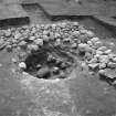
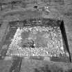
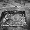
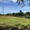
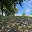
NS 8379 7980 and NS 8346 7980. There are two 'expansions' projecting from the S face of the Antonine Wall rampart at Bonnyside. When visited in 1957, they were roughly semi-circular on plan, measuring about 10.0m E-W at the rampart face by 7.0m N-S, with a maximum height of 1.2m. The eastern expansion was excavated in 1957 by the RCAHMS who showed that it had been rectangular, and would have measured about 19' x 10' at a height of 10' above the ground (the estimated height of the rampart). It was formed of turf set on a stone base, the semi-circular appearance being due to the collapse of the weathered turfwork.
Considerations of siting and the discovery of burnt deposits of wood, turfwork and Roman pottery in the immediate vicinity of the eastern expansion indicate that they were beacon stances, communicating with the area N of the Wall.
Visited by OS (JLD) 24 January 1957.
Sources: K A Steer 1959; RCAHMS 1963, visited 1957.
Note (1978)
Bonnyside East, NS 837 798 NS87NW 4
Signalling Platform.
RCAHMS 1978
(Macdonald, 1934, 130, 350-3; Steer 1957; RCAHMS 1963, pp. 93-6, No.111)
Field Visit (20 November 1980)
No change.
Visited by OS (MJF) 20 November 1980.
Watching Brief (November 2005)
An archaeological watching brief was undertaken in November 2005 near Rough Castle on the Antonine Wall while fencing contractors excavated four postholes for a new gate for the access road. The work area consisted of an opening in the wall across the access road to Rough Castle, with an existing gate and cattle grid. Despite the proximity to extensive Roman structures, there were no finds or features of archaeological significance.
Archive to be deposited in NMRS.
Sponsor: Historic Scotland.
Publication Account (2008)
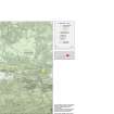
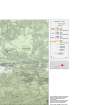
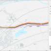
A 1:25000 scale map of the Antonine Wall was published by RCAHMS in 2008. The map shows the course of the Antonine Wall on a modern map base, including areas where the Wall is in public ownership or care and can be visited. The data had been collated as part of the project to prepare maps for the World Heritage Site nomination bid.

