|
Photographs and Off-line Digital Images |
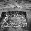
ST 3093 |
Records of the Royal Commission on the Ancient and Historical Monuments of Scotland (RCAHMS), Edinbu |
Excavation photograph |
1957 |
Item Level |
|
|
Photographs and Off-line Digital Images |
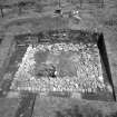
ST 3094 |
Records of the Royal Commission on the Ancient and Historical Monuments of Scotland (RCAHMS), Edinbu |
Excavation photograph |
1957 |
Item Level |
|
|
Photographs and Off-line Digital Images |
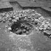
ST 3095 |
Records of the Royal Commission on the Ancient and Historical Monuments of Scotland (RCAHMS), Edinbu |
Excavation photograph showing Roman quarry pit |
1957 |
Item Level |
|
|
Prints and Drawings |
STD 195/1 |
|
Excavation plan PSAS XC 161-9 K A Steer |
1957 |
Item Level |
|
|
Prints and Drawings |
STD 195/2 |
|
PSAS XC 161-9 K A Steer |
1957 |
Item Level |
|
|
Prints and Drawings |
STD 3/2 |
Records of the Royal Commission on the Ancient and Historical Monuments of Scotland (RCAHMS), Edinbu |
Publication drawing; site plan, 'Expansions on the Antonine Wall'. |
3/1960 |
Item Level |
|
|
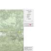
Photographs and Off-line Digital Images |
DC 47351/6 |
Records of the Ordnance Survey, Southampton, Hampshire, England |
Ordnance Survey 6-inch to the mile Provisional Edition, revision of 1943-44 with additions in 1946.
Additional annotations by Ordnance Survey for the Antonine Wall map covering the parish of Falkirk (W) with Rough Castle. |
c. 1946 |
Item Level |
|
 |
On-line Digital Images |
SC 1436382 |
Records of the Royal Commission on the Ancient and Historical Monuments of Scotland (RCAHMS), Edinbu |
Excavation photograph |
1957 |
Item Level |
|
 |
On-line Digital Images |
SC 1664481 |
Records of the Royal Commission on the Ancient and Historical Monuments of Scotland (RCAHMS), Edinbu |
Excavation photograph |
1957 |
Item Level |
|
|
Photographs and Off-line Digital Images |
SC 1664502 |
Records of the Royal Commission on the Ancient and Historical Monuments of Scotland (RCAHMS), Edinbu |
Excavation plan PSAS XC 161-9 K A Steer |
1957 |
Item Level |
|
 |
On-line Digital Images |
SC 1775413 |
Records of the Royal Commission on the Ancient and Historical Monuments of Scotland (RCAHMS), Edinbu |
Excavation photograph showing Roman quarry pit |
1957 |
Item Level |
|
|
Digital Files (Non-image) |
GV 007519 |
Records of Historic Scotland, Edinburgh, Scotland |
Map 3 of 8 from IV.I 1-8 - Series 1: Maps of the Antonine Wall at a scale of 1:25000 showing the proposed World Heritage Site, known forts and fortlets, camps, other features and the buffer zones. Maps were prepared for the nomination document to propose the extension of the Frontiers of the Roman Empire World Heritage Site through the addition of the Antonine Wall. |
2006 |
Item Level |
|
 |
On-line Digital Images |
SC 1926553 |
Records of Historic Scotland, Edinburgh, Scotland |
Map 3 of 8 from IV.I 1-8 - Series 1: Maps of the Antonine Wall at a scale of 1:25000 showing the proposed World Heritage Site, known forts and fortlets, camps, other features and the buffer zones. Maps were prepared for the nomination document to propose the extension of the Frontiers of the Roman Empire World Heritage Site through the addition of the Antonine Wall. |
2006 |
Item Level |
|
 |
On-line Digital Images |
SC 1927846 |
Records of Historic Scotland, Edinburgh, Scotland |
Map 3 of 8 from IV.2 1-8 - Series 2: Maps of the Antonine Wall at a scale of 1:25000 showing the proposed World Heritage Site, known forts and fortlets, camps, other features and the buffer zones. Maps were prepared for the nomination document to propose the extension of the Frontiers of the Roman Empire World Heritage Site through the addition of the Antonine Wall. |
2006 |
Item Level |
|
|
Digital Files (Non-image) |
GV 007526 |
Records of Historic Scotland, Edinburgh, Scotland |
Map 3 of 8 from IV.2 1-8 - Series 2: Maps of the Antonine Wall at a scale of 1:25000 showing the proposed World Heritage Site, known forts and fortlets, camps, other features and the buffer zones. Maps were prepared for the nomination document to propose the extension of the Frontiers of the Roman Empire World Heritage Site through the addition of the Antonine Wall. |
2006 |
Item Level |
|
|
Digital Files (Non-image) |
GV 007547 |
Records of Historic Scotland, Edinburgh, Scotland |
Map 14 of 39 from Series V. Maps of the Antonine Wall and its known features at a scale of 1:5000 showing the scheduled areas and the proposed World Heritage Site. Maps were prepared for the nomination document to propose the extension of the Frontiers of the Roman Empire World Heritage Site through the addition of the Antonine Wall. |
2006 |
Item Level |
|
 |
On-line Digital Images |
SC 1929336 |
Records of Historic Scotland, Edinburgh, Scotland |
Map 14 of 39 from Series V. Maps of the Antonine Wall and its known features at a scale of 1:5000 showing the scheduled areas and the proposed World Heritage Site. Maps were prepared for the nomination document to propose the extension of the Frontiers of the Roman Empire World Heritage Site through the addition of the Antonine Wall. |
2006 |
Item Level |
|
|
Digital Files (Non-image) |
GV 007595 |
Records of Historic Scotland, Edinburgh, Scotland |
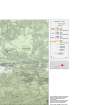
Antonine Wall 1:25000 broadsheet map - created in three sections - this is the central section of the map |
2008 |
Item Level |
|
 |
On-line Digital Images |
SC 1970706 |
Records of Historic Scotland, Edinburgh, Scotland |
Antonine Wall 1:25000 broadsheet map |
2008 |
Item Level |
|
|
Digital Files (Non-image) |
TM 000310 |
Records of Historic Scotland, Edinburgh, Scotland |
Zip file including: a Dxf file containing the polygons created to show the components of the Antonine Wall, along with the associated forts, expansions and military way. Shapefiles containing the same data and an associated layer file. |
2007 |
Item Level |
|
|
Digital Files (Non-image) |
GV 008531 |
Records of Historic Scotland, Edinburgh, Scotland |
Map showing the Antonine Wall, the World Heritage Site area, the areas of the World Heritage Site in public ownership or care, the Buffer Zone and the Council boundaries. Created for the World Heritage Site nomination - Management plan. |
2006 |
Item Level |
|
 |
On-line Digital Images |
SC 2170806 |
Records of Historic Scotland, Edinburgh, Scotland |
Map showing the Antonine Wall, the World Heritage Site area, the areas of the World Heritage Site in public ownership or care, the Buffer Zone and the Council boundaries. Created for the World Heritage Site nomination - Management plan. |
2006 |
Item Level |
|
 |
On-line Digital Images |
SC 2432114 |
Records of the Ordnance Survey, Southampton, Hampshire, England |
Bonnyside East, NS87NW 4, Ordnance Survey index card, Recto |
1958 |
Item Level |
|
 |
On-line Digital Images |
SC 2432115 |
Records of the Ordnance Survey, Southampton, Hampshire, England |
Bonnyside East, NS87NW 4, Ordnance Survey index card, Recto |
1958 |
Item Level |
|


