
Pricing Change
New pricing for orders of material from this site will come into place shortly. Charges for supply of digital images, digitisation on demand, prints and licensing will be altered.
Clydebank, Rothesay Dock


Dock(S) (20th Century)
Site Name Clydebank, Rothesay Dock
Classification Dock(S) (20th Century)
Alternative Name(s) River Clyde
Canmore ID 68384
Site Number NS56NW 51
NGR NS 50101 69102
Datum OSGB36 - NGR
Permalink http://canmore.org.uk/site/68384


- Council West Dunbartonshire
- Parish Old Kilpatrick (Clydebank)
- Former Region Strathclyde
- Former District Clydebank
- Former County Dunbartonshire
NS56NW 51 50101 69102
Rothesay Dock [NAT] (at NS 4991 6935 and NS 5020 6912)
OWS (GIS) MasterMap, January 2010.
Extends onto map sheet NS46NE.
Desk Based Assessment (30 June 2017)
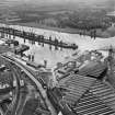
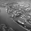
Rothesay Dock is located on the north bank of the River Clyde in Clydebank, opposite the mouth of the River Cart. Originally called the Clydebank Dock, 76 acres of riverbank were purchased from the estates of Yoker Lodge and Barns o’ Clyde by the Clyde Navigation Trust for £81,000 in 1899 for its construction, which began in 1900. It was opened in 1907 by the Prince of Wales and renamed the Rothesay Dock after one of his titles (Duke of Rothesay). The dock comprises an inner and outer basin, lying parallel to the Clyde, the outer basin connected to the river by a 200ft (61m) wide entrance. The outer basin is roughly square on plan and the inner rectangular, measuring 1,735ft by 300ft (529m by 91.5m) at its maximum. The dock was originally designed for coal shipment and iron-ore importation. It had its own power station, built on the north quay, and was the first self-contained system working coal-hoists, cranes and lights in a British port. Four electric powered coal hoists were constructed, which could handle 20-ton coal wagons, as well as 36 4-ton mineral cranes.
Information from HES Survey and Recording (AMcC) 30 June 2017.

