
Pricing Change
New pricing for orders of material from this site will come into place shortly. Charges for supply of digital images, digitisation on demand, prints and licensing will be altered.
Upcoming Maintenance
Please be advised that this website will undergo scheduled maintenance on the following dates:
Thursday, 9 January: 11:00 AM - 3:00 PM
Thursday, 23 January: 11:00 AM - 3:00 PM
Thursday, 30 January: 11:00 AM - 3:00 PM
During these times, some functionality such as image purchasing may be temporarily unavailable. We apologise for any inconvenience this may cause.
Bute, Little Dunagoil


Farmstead (Norse), Settlement (Norse), Weight (Lead)(Viking)
Site Name Bute, Little Dunagoil
Classification Farmstead (Norse), Settlement (Norse), Weight (Lead)(Viking)
Canmore ID 90299
Site Number NS05SE 30
NGR NS 08707 53332
NGR Description NS 08691 53355
Datum OSGB36 - NGR
Permalink http://canmore.org.uk/site/90299


- Council Argyll And Bute
- Parish Kingarth
- Former Region Strathclyde
- Former District Argyll And Bute
- Former County Buteshire
NS05SE 30 08707 53332.
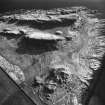
NS 087 532. The craggy site at Little Dunagoil resembles, on a small scale, the class of citadel or nuclear forts exemplified by Dunadd (NR89SW 1). Excavations in 1958-61 showed that it was occupied from the Late Bronze Age up to the 13th century. At 'D' and 'E' are 12th - 13th century long- houses. 'D' was 42 x 22 ft; two sherds of Samian pottery were found there, as well as other pottery of 5th - 7th, and 13th century date. 'E' was 45 x 22 ft; a stone, 3 1/2 ft high, in its E wall, has two cup marks on its inner face.
Marshall 1961; Marshall 1964.
The two longhouses are generally as described.
Surveyed at 1:10 000.
Visited by OS (B S) 11 November 1976.
NS 086 533 Site 4 Little Dunagoil
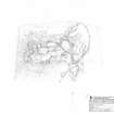
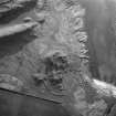
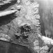
Just inside the stone and turf dyke on the E side of the fort are the remains of two large rectangular buildings. These structures are unique on Bute, being 7m broad internally, with walls up to 2m thick, and having apparently a very broad doorway in the gable end. They were interpreted as Viking type longhouses of 12th - 13th century date when excavated (Marshall 1964, 30-34), but a full re-assessment is needed. A probable house platform of normal proportions (previously unrecorded) lies within the fort above.
Proudfoot and Hannah 2000
NS 0868 5336 Building remains: Located below outcrop at S end of Dunagoil Bay, just inside low stone and turf dyke surrounding Little Dunagoil fort on E side. There are the remains of two large rectangular structures. N building with N wall 2m thick, 16 x 7.5m internal dimensions with broad 2.5m wide doorway in E gable. Partly excavated in 1963 (Trans BNHS; where interpreted as longhouses). S building 16 x 9 external with walls 1.5m thick. Traces of 3rd building of normal proportions aligned downhill on cleared sloping platform higher up.
Information from Bute Natural History Society Deserted Settlement Survey (1991-9)
(RCAHMS WP000273)
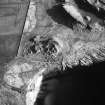
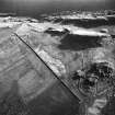
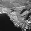
This farmstead is situated in rough pasture at the foot of the NE flank of Little Dunagoil, a craggy volcanic plug 340m SW of Dunagoil farmsteading on which stands the fort NS05SE 14. The farmstead comprises at least two buildings, which were excavated by Marshall between 1958 and 1961. Subrectangular on plan, they measure up to about 14m in length by 7m in breadth within walls about 1.5m thick and they were interpreted as Norse longhouses of 12th to 13th century date (Marshall 1964, 30). One of the buildings (NS 08691 53355) can still be clearly seen, but only the footings of the side-walls of the other (NS 08707 53332) are still visible. The grass-grown stony bank that encloses the buildings may be of considerably later date as it is depicted enclosing 'Donnegoil Park' on an 18th century estate map (Foulis 1758-9).
Visited by RCAHMS (GFG, AGCH, ARG) 20 March 2009.
Field Visit (11 November 1976)
The two longhouses are generally as described.
Surveyed at 1:10 000.
Visited by OS (B S) 11 November 1976.
Field Visit (1991 - 1999)
NS 086 533 Site 4 Little Dunagoil
Just inside the stone and turf dyke on the E side of the fort are the remains of two large rectangular buildings. These structures are unique on Bute, being 7m broad internally, with walls up to 2m thick, and having apparently a very broad doorway in the gable end. They were interpreted as Viking type longhouses of 12th - 13th century date when excavated (Marshall 1964, 30-34), but a full re-assessment is needed. A probable house platform of normal proportions (previously unrecorded) lies within the fort above.
Proudfoot and Hannah 2000
NS 0868 5336 Building remains: Located below outcrop at S end of Dunagoil Bay, just inside low stone and turf dyke surrounding Little Dunagoil fort on E side. There are the remains of two large rectangular structures. N building with N wall 2m thick, 16 x 7.5m internal dimensions with broad 2.5m wide doorway in E gable. Partly excavated in 1963 (Trans BNHS; where interpreted as longhouses). S building 16 x 9 external with walls 1.5m thick. Traces of 3rd building of normal proportions aligned downhill on cleared sloping platform higher up.
Information from Bute Natural History Society Deserted Settlement Survey (1991-9)
(RCAHMS WP000273)
Reference (2004)
Field Visit (20 March 2009)
This farmstead is situated in rough pasture at the foot of the NE flank of Little Dunagoil, a craggy volcanic plug 340m SW of Dunagoil farmsteading on which stands the fort NS05SE 14. The farmstead comprises at least two buildings, which were excavated by Marshall between 1958 and 1961. Subrectangular on plan, they measure up to about 14m in length by 7m in breadth within walls about 1.5m thick and they were interpreted as Norse longhouses of 12th to 13th century date (Marshall 1964, 30). One of the buildings (NS 08691 53355) can still be clearly seen, but only the footings of the side-walls of the other (NS 08707 53332) are still visible. The grass-grown stony bank that encloses the buildings may be of considerably later date as it is depicted enclosing 'Donnegoil Park' on an 18th century estate map (Foulis 1758-9).
Visited by RCAHMS (GFG, AGCH, ARG) 20 March 2009.
Measured Survey (17 March 2010 - 18 March 2010)
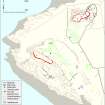
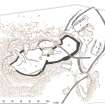
RCAHMS surveyed the fort and farmstead at Little Dunagoil between 17-18 March 2010 with plane table and self-reducing alidade at a scale of 1:500. The plan was redrawn in vector graphics software for publication at a scale of 1:1000 (Geddes and Hale 2010, 31).
Note
NS 087 532. The craggy site at Little Dunagoil resembles, on a small scale, the class of citadel or nuclear forts exemplified by Dunadd (NR89SW 1). Excavations in 1958-61 showed that it was occupied from the Late Bronze Age up to the 13th century. At 'D' and 'E' are 12th - 13th century long- houses. 'D' was 42 x 22 ft; two sherds of Samian pottery were found there, as well as other pottery of 5th - 7th, and 13th century date. 'E' was 45 x 22 ft; a stone, 3 1/2 ft high, in its E wall, has two cup marks on its inner face.

