
Campbeltown Airfield


Airfield (20th Century), Military Airfield (Second World War), Military Airfield (First World War)
Site Name Campbeltown Airfield
Classification Airfield (20th Century), Military Airfield (Second World War), Military Airfield (First World War)
Alternative Name(s) Hms Landrail Ii; The Strath Airfield; Dalivaddy: Machrihanish
Canmore ID 91749
Site Number NR62SE 27
NGR NR 6779 2000
NGR Description Centred NR 6779 2000
Datum OSGB36 - NGR
Permalink http://canmore.org.uk/site/91749


- Council Argyll And Bute
- Parish Campbeltown
- Former Region Strathclyde
- Former District Argyll And Bute
- Former County Argyll
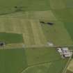
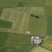
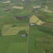
Campbeltown military aerodrome was used in both First and Second World Wars. In the First World War it was known as Machrahanish. It lay to the south of the later Machrahanish aerodrome, which was built in the Second World War and continued in use throughout the Cold War. The First World War aerodrome occupied what would become the eastern part of the Second World War Campbeltown aerodrome.
In a RAF survey of aerodromes in 1918 Machrahanish was described as ‘Marine Operations (Aeroplane) Station, No. 272 Squadron’ the purpose of which was to act as HQ for the squadron and its flights 531, 532 and 533 for anti-submarine patrols, under the command of the Senior Naval Officer at Larne. The aerodrome had an area of 26 hectares, measuring 548m by 503m. The aerodrome had no permanent buildings, the aircraft being housed in canvas Bessoneaux hangars and the men in wooden “Armstrong” huts. The establishment of the station was 179 officers and men and 18 DH6 aircraft (a type designed for training but used for anti-submarine work from 1917 until the end of the war). 272 Squadron was formed in July 1918 and disbanded in March 1919.
The Machrihanish station was also used as a sub-station for airships based at Luce Bay; these sub-stations were used for the airships to moor if the wind prevented an airship getting back to its base.
Information from HS/RCAHMS World War One Audit Project (GJB) 31 May 2013
NR62SE 27 Centred 6779 1992
Part of this site falls on Map sheet NR61NE
A small airfield situated just to the SE of Machrihanish Airfield (NR62SE 28). The control tower was a hut and the fact that the two airfields overlapped also precluded any development and it closed in mid-1945.
D J Smith 1983
This World War II airfield is situated at the SE end of Machrihanish Airfield (NR62SE 28).
J Guy 2001; NMRS MS 810/11, Part 1, 42-5
1930s Civil airfield which was requisitioned by the military in 1940. The site had its origins in World War I being used for anti-submarine patrols over the Clyde. In the 1930s used by Midland and Scottish Air ferries for scheduled flights to Islay and Renfrew. Commissioned in April 1941 as HMS Landrail becoming Landrail II in June 1941 when Machrihanish was opened. Two grass runways and four 60' x 70' hangars were known to have been built here along with perimeter tracks and seven double dispersal pens. It is not known whether there was a watch office (control tower).
Airfield Review October 2002.
Campbeltown Airfield is visible on an RAF WW II vertical air photograph (NLA 21, 620, flown 19 November 1941) in fields immediately E of Dalivaddy Farmsteading. Visible on the photographs are several buildings adjacent to Dalivaddy farm and a group of aircraft parked to the N of the field boundary between the fields and the B843 road. On RAF postwar vertical air photographs (106G/Scot/UK157, 3022-3023, 4118, flown 24 August 1946) at least one aircraft hangar and six Nissen huts are visible. To the E and N of the road traces of the perimeter taxiways are also visible on the photographs.
Two large rectangular concrete silage bins have been constructed in the what was the technical area centred at NR 6780 1990.
Nothing is depicted in this area on the current digital OS 1:2500 scale map.
Information from RCAHMS (DE), October 2004
Note (4 June 2013)
The naming of the aerodromes is confusing. During WW1 this airfield was known as Machrihanish. By WW2 the name was now Campbeltown.
Information from RCAHMS (AKK) 4 June 2013.
Project (March 2013 - September 2013)
A project to characterise the quantity and quality of the Scottish resource of known surviving remains of the First World War. Carried out in partnership between Historic Scotland and RCAHMS.

