
Craig Hill


Broch (Iron Age)(Possible), Cup Marked Stone (Neolithic), Fort (Iron Age)
Site Name Craig Hill
Classification Broch (Iron Age)(Possible), Cup Marked Stone (Neolithic), Fort (Iron Age)
Canmore ID 33365
Site Number NO43NW 22
NGR NO 432 358
Datum OSGB36 - NGR
Permalink http://canmore.org.uk/site/33365


- Council Angus
- Parish Murroes (Angus)
- Former Region Tayside
- Former District City Of Dundee
- Former County Angus
NO43NW 22 432 358.
(NO 4325 3585) Fort and Broch (NR) (remains of)
OS 6" map, (1971)
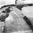
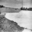
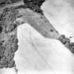
The denuded remains of a fort on an E-W escarpment into whose W end a broch with outwork has been inserted.
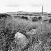
The broch, cleared by the RCAHMS in 1957, now remains only as a foundation 15' thick enclosing an area 35' in diameter. The entrance, 0.9m wide, is in the E. Facing stones are visiblg on both the outside and inside of the wall, those on the outside being larger.
The outwork, consisting of a wall with an external ditch, cuts across the ridge 16m E of the broch. The wall is 2m high above the base of the ditch, whose counter scarp is 0.6m high. A causeway 4.2m wide crosses this defence opposite the broch entrance.
These works end abruptly at a short natural terrace from which the ground slopes gently downwards for c. 18m to the edge of the steep escarpment on the N.
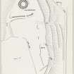
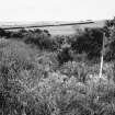
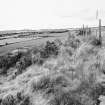
From this point the wall of the earlier fort can be traced running westwards for c. 40m to the fence on the scarp edge, and eastwards for c. 120m when it curves southwards as a short scarp 1.2m high. It leaves the cleared wood here and is then completely lost in a ploughed field but it no doubt ran SW to meet the escarpmgnt on the S. The only other trace of the wall occurs on the edge of the escarpment 20m W of the broch. A hollow-way running NE-SW up the hillside and breaking the wall of the fort at a point 70m NE of the broch may be the original entrance, other breaks in the wall to the E probably being modern.
Three possible hut circles occur on the short terrace immediately N of the broch at NO 4320 3588.
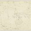
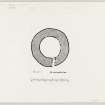
A possible cup marked stone, triangular, 0.8m by 0.4m, is embedded in the ground 3m E of the entrance to the broch. The 14 cups on the surface may be the result of weathering.
K A Steer 1957; Visited by OS (J L D) 21 May 1958.
3-4 lines of ditches appear on RCAHMS air photographs on the S and E sides of the fort.
Field Visit (19 April 1957 - 20 April 1957)
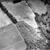
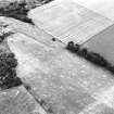
The remains of an Early Iron Age fort with a later broch built inside it are situated 500 yds west of Craighill farmhouse occupying the west end of a flat-topped spur of land running east and west. From the farm the ground rises very gradually westwards to a height of 441 ft OD at its western extremity where it terminates in a steep rocky face overlooking a sharp bend in the Fithie Burn 100 ft to 150 ft below. The north and south flanks of the spur are steeply inclined and the only easy approach is from the east.
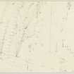
Little now remains of the fort, but it appears to have had an elongated oval shape, measuring approximately 550 ft from east to west by 230 ft transversely within at least three ramparts. The whole of the southeast arc of the defences has been destroyed by cultivation, and on the southwest and west all traces have now disappeared, partly at least as a result of extensive quarrying which has taken place round the northwest face of the spur. On the north side, however, and round the northeast angle the wasted remains of three ramparts, and part of what is probably a fourth, are still visible, the inner one following the edge of the summit area, and the others ranged at intervals down the slope below it. They are all reduced to grassy terraces or mere crest-lines in which intermittent stretches of stony rubble appear. There is no evidence to show whether any of the three tracks that lead through the defences on the north side is similar; they have all been in use in comparatively recent times and are probably associated with the line of quarried rock-faces shown on the plan aligned east to west some 50ft inside the top crest-line.
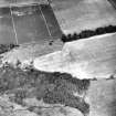
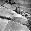
The broch, accompanied by an outer defensive work to the east of it, lies within 25 ft of the western tip of the spur. Excavations were carried out at the time of visit with the help of Mr DB Taylor and a party of schoolboys from the Harris Academy, Dundee. Before the work began the remains of the broch appeared as a low grass-grown mound through which the tops of a few stones protruded. Sufficient clearance was made to reveal that the broch wall is almost circular, having an external diameter of 65 ft and a thickness of 15 ft, with an entrance facing east. The outer face was cleared down to the level of the natural subsoil on which it rested and was found to be standing to a maximum height of 2 ft in two courses and to be complete throughout its circuit. The foundation course consists, for the most part, of long flat blocks, laid horizontally and measuring up to 3 ft in length by one ft in height. Such stones as remain of the second course are angular and untrimmed, being about 1ft 6 in to 2 ft square, with the gaps between them filled, where necessary, by pinnings of small stones. The inner face is of similar construction, though the size of the stones employed is rather smaller than those in the outer face. The best preserved section uncovered extends immediately south of the entrance, where three well-built courses are visible standing to a height of nearly 2 ft. It was impossible in the time available to attempt to clear the interior of the broch or the entrance passage and the quantity of debris present suggest that several courses of the inner face may still remain buried. The entrance measures 4 ft 3 in at its inner end and the north and south side-walls of the passage were traced outwards for a distance of 8 ft and 9 ft respectively. The south wall appears to be straight while the north wall is slightly concave. At a distance of 5 ft from the inner edge of the north side-wall a narrow opening, 2 ft wide, leads to a mural chamber, the dimensions of which were not discovered. No signs of door-checks are visible. A large block, measuring 5 ft in length by 2 ft in breadth, which lies on top of the debris filling the passage is clearly a dislodged lintel-stone.
The broch is protected to the east, where it is most vulnerable, by an outer defensive work drawing transversely across the summit of the ridge from north to south. It consists of a stone-revetted rampart composed of earth and small stones thrown up from an external quarry-ditch, with an entrance, 13 ft wide, situated in line with that of the broch. South of the entrance the rampart and ditch extend as far as the edge of the natural scarp where they have been partly destroyed by a modern track running obliquely up the slope; north of the entrance only a stretch of 50 ft now survives, but the work must have originally continued to the edge of the north flank of the spur. The rampart stands to a maximum height of 2 ft above the interior and 6 ft above the bottom of he ditch, and would have had a thickness of about 6 ft though it is now spread to as much as 15 ft. Portions of the bottom course of a heavy stone revetment were discovered on the outer edge of the rampart and also along the ends flanking either side of the entrance, consisting of boulders measuring up to 1 ft 6 ins in height and 2 ft in length. Although no facing-stones are at present visible on the inner edge of the rampart, the loose composition of the core-material makes it probably that they existed originally. The ditch, which has a greatest depth of 4 ft below the exterior ground level is partly rock cut and of ragged outline.
Situated 8 ft east of the broch entrance and roughly in line with the south side of the passage there is a boulder protruding through the turf, on the upper surface of which are 15 plain cup-marks, and a number of other possible, concentrated within an area 2 ft by 2 ft 6 in. the cups are of normal size, measuring 1.5 in. to 3 in. in diameter and up to half an inch in depth. None of them is ringed.
Visited by RCAHMS 19-20 April 1957
Reference (1963)
This site is noted in the ‘List of monuments discovered during the survey of marginal land (1956-8)’, published in Vol. 1 of the RCAHMS Inventory of Stirlingshire. The 26 monuments were listed by their name, classification, parish and county, and the list also includes an indication of whether they had been planned (P), whether they were visible only as a cropmark (C), and whether they were worthy of preservation (*).
Information from RCAHMS (GFG) 30 October 2012.
Publication Account (2007)
NO43 1 CRAIG HILL
NO/432358
This possible broch in Murroes has been inserted into the west end of the denuded remains of an earlier fort on an east-west escarpment. The supposed broch, cleared by the RCAHMS in 1957, now remains only as a wall foundation 4.6m (15 ft) thick enclosing an area 10.7m (35 ft) in diameter. The entrance faces east and is 0.9m wide. Facing stones are visible on both the outside and inside of the wall, those on the outside being larger.
The outwork, consisting of a wall with an external ditch, cuts across the ridge 16m east of the broch. The wall is 2m high above the base of the ditch, whose counter-scarp is 0.6m high. A causeway 4.2m wide crosses this defence opposite the broch entrance. Three possible hut circles occur on the short terrace immediately north of the broch at NO 4320 3588. More details of the hillfort are given [1].
Sources: 1. NMRS site no. NO 43 NW 22: 2. K A Steer in Discovery and Excavation in Scotland 1957, 39.
E W MacKie 2007
Note (27 May 2015 - 1 November 2016)
This fort, and the broch within the W end of its interior, occupies the summit of Craig Hill, which forms the W end of a long ridge of hard rock with steep slopes falling away on the W and along the S flank. The slopes are particularly steep around the W end, where the summit area rises no more than 10m across the crest of the ridge, providing a strong position for the fort, which is oval on plan and measures internally about 180m from E to W by 70m transversely (1.2ha). Under trees throughout the 19th and early 20th centuries, it was first discovered by RCAHMS investigators, who drew a plan showing at least two ramparts reduced to stony scarps extending the length of the N flank, with fragments of two others on the slope below, while oblique aerial photography since has revealed the cropmarks of three or four concentric ditches cutting back across the crest of the ridge on the E to return along the S flank, where otherwise no trace of the defences has survived cultivation and quarrying. No less than four old trackways can be seen climbing the slope, three on the N and one on the S, but there is no evidence that any is an original entrance and the three on the N may have been servicing the quarries visible along this side of the interior. These quarries are probably responsible for removing the N end of what is assumed to be an outwork to the broch, partitioning off the W extremity of the interior. Comprising a stone-faced rampart spread about 4.5m in thickness by 0.6m in height, with an external rock-cut ditch 4m in breadth by 1.2m in depth, this forms a triangular enclosure in the W end of the fort measuring a maximum of 68m from N to S by 48m transversely (0.2ha). An entrance causeway in the middle of the E side faces directly towards the broch, which measures 10.6m in diameter within a wall 4.5m in thickness. While the supposed earthwork might be contemporary with the broch, it may just as easily be the remains of a free-standing defensive enclosure utilising the earlier fortifications. The OS noted three possible hut-circle immediately to the N of the broch, but this impression may have been caused by the probable quarrying in this area.
Information from An Atlas of Hillforts of Great Britain and Ireland – 01 November 2016. Atlas of Hillforts SC3082

