
Pricing Change
New pricing for orders of material from this site will come into place shortly. Charges for supply of digital images, digitisation on demand, prints and licensing will be altered.
Kinpurney Hill


Fort (Prehistoric), Plantation Bank (18th Century) - (19th Century)
Site Name Kinpurney Hill
Classification Fort (Prehistoric), Plantation Bank (18th Century) - (19th Century)
Alternative Name(s) Kinpurnie Hill
Canmore ID 32170
Site Number NO34SW 7
NGR NO 3227 4177
Datum OSGB36 - NGR
Permalink http://canmore.org.uk/site/32170


- Council Angus
- Parish Newtyle
- Former Region Tayside
- Former District Angus
- Former County Angus
NO34SW 7 3227 4177
For observatory within the area of the fort, see NO34SW 39.
(NO 3227 4177) Fort (NR)
OS 25" map, (1972)
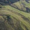
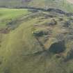
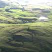
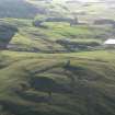
An unfinished fort with an area of 16 1/2 acres was discovered on Kinpurney Hill during the Marginal Lands Survey between 1956 and 1958. It is considered worthy of preservation.
RCAHMS 1963; R W Feachem 1966.
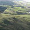
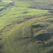
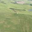
An unfinished fort, sub-oval on plan, consisting of a rampart and ditch, encircling Kinpurney Hill, some 100' below its summit. Where evident, the rampart is generally reduced to a scarp, c. 2.0m high on average, and the ditch to a narrow terrace. On the S side, along the steep natural slope, there is little evidence of the rampart and none of the ditch. The entrance is in the middle of the W side.
Surveyed at 1:2500.
Visited by OS (W D J) 7 December 1967.
Vitrified rock from here is in Brechin Museum (1977.311).
Letter from G W Zealand, Angus District Museums to Ordnance Survey, 20 November 1978.
Reference (1963)
This site is noted in the ‘List of monuments discovered during the survey of marginal land (1956-8)’, published in Vol. 1 of the RCAHMS Inventory of Stirlingshire. The 26 monuments were listed by their name, classification, parish and county, and the list also includes an indication of whether they had been planned (P), whether they were visible only as a cropmark (C), and whether they were worthy of preservation (*).
Information from RCAHMS (GFG) 30 October 2012.
Note (1983)
Kinpurney Hill NO 322 417 NO34SW 7
This large fort (6.6ha) is situated on Kinpurney Hill and is defended by a single rampart and ditch. The entrance is on the W.
RCAHMS 1983
Note (25 May 2015 - 18 November 2016)
This fort is situated on Kinpurney Hill, which is crowned by the shell of an observatory tower built in 1774, from which it was claimed in 1791 that St Abbs Head, Berwickshire could be seen, along with parts of ten or eleven separate counties (Stat Acct, iii, 1791, 403). Roughly oval on plan, the interior of the fort measures about 360m from NE to SW by 240m transversely (6.83ha). The defences comprise a single rampart accompanied by an external ditch, though at best these are reduced to a scarp dropping some 2m to a narrow terrace, and along the lip of the rocky slope along the SE flank there is little trace of either. Nevertheless, at least four probable entrances can be identified on the NNE, NE, WSW and WNW respectively, of which that on the NE has possible traces of short inturns to either side of a trackway leading up into the interior, while that on the WSW forms a deep re-entrant where the rampart turns inwards to either side of a shallow natural gully apparently facing towards Schiehallion, a distant summit that can be discerned on the horizon some 60km to the WNW; the other two gaps are also in shallow gullies. No clear stances for timber round-houses are visible within the interior, and apart from the tower on the summit the only other feature is a roughly square plantation enclosure of about 1.35ha surrounding it. The ephemeral character of the defences led Richard Feachem to suggest the fort was unfinished, but the slight stature of the rampart in general, and its apparent absence along the SE flank, is entirely in keeping with other large hilltop enclosures and the circuit is probably much as the builders intended it.
Information from An Atlas of Hillforts of Great Britain and Ireland – 18 November 2016. Atlas of Hillforts SC3073

