|
Photographs and Off-line Digital Images |
AN 4659 |
John Dewar |
Oblique aerial view.
|
1971 |
Item Level |
|
|
Photographs and Off-line Digital Images |
AN 4660 |
John Dewar |
Oblique aerial view.
|
1971 |
Item Level |
|
|
Photographs and Off-line Digital Images |
AN 4661 |
John Dewar |
Oblique aerial view.
|
1971 |
Item Level |
|
|
Photographs and Off-line Digital Images |
AN 4684 |
John Dewar |
Oblique aerial view.
|
1971 |
Item Level |
|
|
Photographs and Off-line Digital Images |
AN 4685 |
John Dewar |
Oblique aerial view.
|
1971 |
Item Level |
|
|
Photographs and Off-line Digital Images |
AN 4686 |
John Dewar |
Oblique aerial view.
|
1971 |
Item Level |
|
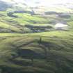 |
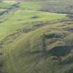
On-line Digital Images |
DP 056606 |
RCAHMS Aerial Photography Digital |
Oblique aerial view centred on the remains of the the fort, the plantation bank and the ruins of the observatory, taken from the NNW. |
22/10/2008 |
Item Level |
|
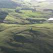 |
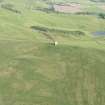
On-line Digital Images |
DP 056607 |
RCAHMS Aerial Photography Digital |
Oblique aerial view centred on the remains of the the fort, the plantation bank and the ruins of the observatory, taken from the NW. |
22/10/2008 |
Item Level |
|
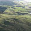 |
On-line Digital Images |
DP 056608 |
RCAHMS Aerial Photography Digital |
Oblique aerial view centred on the remains of the the fort, the plantation bank and the ruins of the observatory, taken from the WNW. |
22/10/2008 |
Item Level |
|
 |
On-line Digital Images |
DP 056609 |
RCAHMS Aerial Photography Digital |
Oblique aerial view centred on the remains of the the fort, the plantation bank and the ruins of the observatory, taken from the NE. |
22/10/2008 |
Item Level |
|
 |
On-line Digital Images |
DP 056610 |
RCAHMS Aerial Photography Digital |
Oblique aerial view centred on the remains of the the fort, the plantation bank and the ruins of the observatory, taken from the NE. |
22/10/2008 |
Item Level |
|
 |
On-line Digital Images |
DP 056611 |
RCAHMS Aerial Photography Digital |
Oblique aerial view centred on the remains of the the fort, the plantation bank and the ruins of the observatory, taken from the W. |
22/10/2008 |
Item Level |
|
 |
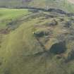
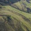
On-line Digital Images |
DP 162818 |
RCAHMS Aerial Photography Digital |
Oblique aerial view of Kinpurney Hill, looking SSE. |
19/6/2013 |
Item Level |
|
 |
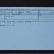
On-line Digital Images |
SC 2404112 |
Records of the Ordnance Survey, Southampton, Hampshire, England |
Kinpurney Hill, NO34SW 7, Ordnance Survey index card, Recto |
c. 1958 |
Item Level |
|
 |
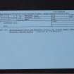
On-line Digital Images |
SC 2404113 |
Records of the Ordnance Survey, Southampton, Hampshire, England |
Kinpurney Hill, NO34SW 7, Ordnance Survey index card, Recto |
c. 1958 |
Item Level |
|
 |
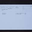
On-line Digital Images |
SC 2404114 |
Records of the Ordnance Survey, Southampton, Hampshire, England |
Kinpurney Hill, NO34SW 7, Ordnance Survey index card, Recto |
c. 1958 |
Item Level |
|
 |
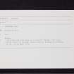
On-line Digital Images |
SC 2404115 |
Records of the Ordnance Survey, Southampton, Hampshire, England |
Kinpurney Hill, NO34SW 7, Ordnance Survey index card, Recto |
c. 1958 |
Item Level |
|
 |
On-line Digital Images |
SC 2404116 |
Records of the Ordnance Survey, Southampton, Hampshire, England |
Kinpurney Hill, NO34SW 7, Ordnance Survey index card, Recto |
c. 1958 |
Item Level |
|
|
All Other |
551 166/1/1 |
Records of the Ordnance Survey, Southampton, Hampshire, England |
Archaeological site card index ('495' cards) |
1947 |
Sub-Group Level |
|


