
Pricing Change
New pricing for orders of material from this site will come into place shortly. Charges for supply of digital images, digitisation on demand, prints and licensing will be altered.
Strone Hill, Abbot's Cross


Boundary Marker (Medieval) - (Post Medieval)
Site Name Strone Hill, Abbot's Cross
Classification Boundary Marker (Medieval) - (Post Medieval)
Canmore ID 31014
Site Number NO25NE 6
NGR NO 29220 56596
Datum OSGB36 - NGR
Permalink http://canmore.org.uk/site/31014


- Council Angus
- Parish Lintrathen
- Former Region Tayside
- Former District Angus
- Former County Angus
NO25NE 6 2921 5658.
About 400 yds SW of the top of Strone Hill is the 'Abbot's Cross', a collection of boulders, arranged in two arms or ridges, intersecting one another at right angles; each arm is c. 6 1/2' wide, one arm, 36' long and the other, 34' long. The stones were piled to form ridges varying from 2' - 2 1/2' above ground level, and most of them are now overgrown with grass and heather, but at the outward ends of the arms the largest boulders are placed. In the centre, where the arms intersect, is a cavity about 1' deep and 2' in diameter, which was probably occupied originally by an upright stone, now removed.
This is possibly the site of a boundary stone set up by the Abbot of Arbroath about the end of the 12th c (Warden gives the date '1253') to mark the limit of Kingoldrum estate, owned by the Abbey. Fenton adds that the cross-stone is not mentioned in early documents, viz: 1253, 1256 and 1458.
W Fenton 1948; A J Warden 1884
NO 2921 5658. Abbot's Cross appears as raised strips of earth in the form of a cross, each arm measuring 10.0m and 0.3m in height, spread to 2.7m. It has a setting of small boulders at the extremities of each arm, and a small cavity in the centre. It is situated on the SW- facing slope of Strone Hill.
Surveyed at 1:2500.
Visited by OS (NKB) 22 November 1967
Note (1984)
Abbot's Cross, Strone Hill NO 292 565 NO25NE 6
Situated 370m W of the summit of Strone Hill there are the remains of a low cairn. The cairn is cruciform on plan, the arms measuring 10m in length, 0.3m in height and up to 2. 7m in width; it may have been constructed to mark the boundary of the lands of the Abbey of Arbroath.
RCAHMS 1984.
(Warden 1880-85, iv, 28; Fenton 1946).
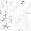
Measured Survey (1997)
A detailed survey of Strone Hill, near Lintrathen in Angus, was undertaken at a scale of 1:1000 on behalf of Historic Scotland. The west end of Strone Hill covers an area of about 16.4ha (40.5 acres) and contains elements of a well-preserved prehistoric landscape, including up to three ring-cairns, a burial cairn, a possible four-poster, about 22 hut-circles (including some with double walls of Dalrulzion-type), a large number of small cairns, and linear fields defined by stony banks. Later remains include a farmstead with a kiln-barn, a number of other subrectangular buildings, huts, enclosures and rig. Two enigmatic stone-built features were surveyed at 1:100. One, known as 'The Abbot's Cross', is a cross of fairly regular plan measuring about 10m overall, whilst the other has five arms and measures up to 18m across. Both may relate to the boundaries of the lands held by Arbroath Abbey in the Middle Ages.
RCAHMS (DES 1997, 88)

