
Pricing Change
New pricing for orders of material from this site will come into place shortly. Charges for supply of digital images, digitisation on demand, prints and licensing will be altered.
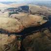
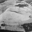
Down Hill


Fort (Period Unassigned)
Site Name Down Hill
Classification Fort (Period Unassigned)
Alternative Name(s) Down Hill, Glen Devon
Canmore ID 26533
Site Number NO00SW 8
NGR NO 00075 03649
Datum OSGB36 - NGR
Permalink http://canmore.org.uk/site/26533


- Council Perth And Kinross
- Parish Glendevon
- Former Region Tayside
- Former District Perth And Kinross
- Former County Perthshire
NO00SW 8 0007 0364.
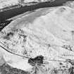
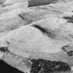
(NO 0007 0364) On the summit of Down Hill (= Dun Hill) are the much defaced remains of a hill fort with surrounding earthworks (Scobie 1910). It was noted during the survey of marginal lands (1956-8) (RCAHMS 1963).
J Scobie 1910; RCAHMS 1963.
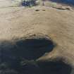
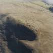
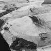
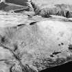
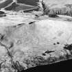
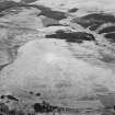
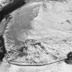
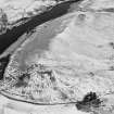
The summit of Down Hill is occupied by a fort of two phases. Phase I is probably represented by a citadel or small stone-walled fort on the flattish summit area of the hill. In phase II the SW and NE flanks were fortified by a series of stony ramparts now generally reduced to terracing; the south east end was defended by triple ramparts with medial ditches, and on the NW side the steep natural slopes, which may have been scarped, probably afforded sufficient defence in themselves. The 'citadel' now occupied by a ruinous stone-walled stock enclosure which partially obscures the original rampart, was probably entered from the NW. The entrance to the later fort was probably from the south east.
Surveyed at 1/2500.
Visited by OS (R D) 6 July 1967.
Reference (1963)
This site is noted in the ‘List of monuments discovered during the survey of marginal land (1956-8)’, published in Vol. 1 of the RCAHMS Inventory of Stirlingshire. The 26 monuments were listed by their name, classification, parish and county, and the list also includes an indication of whether they had been planned (P), whether they were visible only as a cropmark (C), and whether they were worthy of preservation (*).
Information from RCAHMS (GFG) 30 October 2012.
Note (30 April 2015 - 31 August 2016)
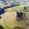
This fort occupies the summit of Down Hill, a steep-sided hill commanding the S end of the route through the Ochils via Glen Devon. The defences have two main components: an elongated inner enclosure on the summit of the hill; and an outer enclosure with at least two ramparts extending round the contour lower down the slope. The inner enclosure is roughly coffin-shaped on plan, its interior measuring 65m from NW to SE by up to 26m transversely (0.14ha), but its perimeter is largely obscured by the wall of a stock enclosure, which first makes its appearance on the 1st edition of the OS 25-inch map published surveyed in 1894-5 (Kinrosshire 1896, sheet 17.13). The OS noted that on the SE the outer defences comprise three ramparts with intermediate ditches, though only the two outer are clearly visible on aerial photographs, their stony scarps extending along the flanks on the NE and SW round on to the steeper NW. Roughly oval on plan, the precise extent of this enclosure is not recorded, but it measures at least 85m from NW to SE by 45m transversely (0.38ha). There are two entrances, one with a trackway climbing obliquely up the slope to the summit from the N apex of the outermost circuit, and the other on the SE. While the OS suggest that the outer defences are a secondary addition to the inner enclosure, no evidence is advanced to support this case and it appears as likley that the inner is an insertion into an earlier fort.
Information from An Atlas of Hillforts of Great Britain and Ireland – 31 August 2016. Atlas of Hillforts SC2993
Note (5 December 2023)
Title: Interdisciplinary approaches to a connected landscape: upland survey in the Northern Ochils.
Authors: Michael Given, Oscar Aldred, Kevin Grant, Peter McNiven and Tessa Poller
Journal: Proceedings of the Society of Antiquaries of Scotland 148, pages 83-111
Publisher: Society of Antiquaries of Scotland, Edinburgh
Publication date: 2019
From: MCE 2023. This project was reviewed as part of the Grant-Aided Project Review (GAPR). Publication was completed in 2019. Open Access publication with the Society of Antiquaries of Scotland. Publication grant-aided by HES

