
Pricing Change
New pricing for orders of material from this site will come into place shortly. Charges for supply of digital images, digitisation on demand, prints and licensing will be altered.
Wallace's Stone


Stone Row (Neolithic) - (Bronze Age)
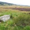
Site Name Wallace's Stone
Classification Stone Row (Neolithic) - (Bronze Age)
Alternative Name(s) Lairhill; Doune
Canmore ID 25274
Site Number NN80SW 2
NGR NN 83260 02286
NGR Description NN 8307 0214 to NN 8330 0232
Datum OSGB36 - NGR
Permalink http://canmore.org.uk/site/25274


- Council Stirling
- Parish Dunblane And Lecropt
- Former Region Central
- Former District Stirling
- Former County Perthshire
NN80SW 2 8307 0214 to 8330 0232
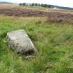
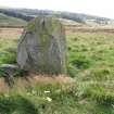
(NN 8324 0226) Wallace's Stone (NR).
OS 6" map, (1959)
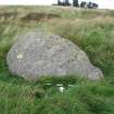
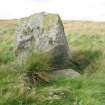
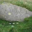
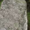
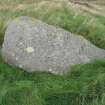
An upright stone, six foot high, three wide and two thick. Traditionally the site of a battle between Wallace and the English, the stone being placed here by Wallace to commemorate the event.
Name Book 1863.
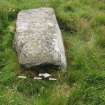
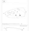
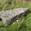
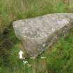
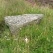
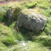
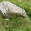
In addition to the Wallace Stone, five other stones, now prostrate, seemed to have formed a series running in a direction south-west to north-east, 253 degrees. The first is 7ft long, 8ft in circumference at one end and 6ft at the other. On the exposed side, which, when the stone was erect, would be the SE, are over 20 cup-marks, from 1 1/2 to 2ins in diameter. About 75 yards distant and in the same line with the standing stone lies a roughly rectangular stone 6ft 6ins long and about 10ft in circumference. The next in the series is a flat stone 5ft 6ins long and 4ft 6ins broad, sunk in the ground, and slightly out of line but near it and in more exact line is a small stone 4ft long. These may be fragments of a single stone. The interval between this and the standing stone is about 150 yards, which suggests that a stone is missing. Next is the Wallace Stone and beyond this in the same line at a distance of about 75 yards, is a stone 10ft long and from 16 to 18ft in girth. Associated with Wallace by an incident narrated by Blind Harry (now discredited).
A F Hutchison 1893.
NN 8307 0214 - NN 8330 0232. Hutchison (1893) is probably correct in suggesting an alignment of stones here. The stones are generally as described by him but the stone 4ft long, close to the middle one 'C' must be considered extremely doubtful as either having been a standing stone or even a fragment of stone 'C'. Stone 'B' is now split. On stone 'A' there are at least 19 cup-marks, mostly indistinct but probably true cup-marks.
Visited by OS (W D J) 8 June 1967.
Field Visit (September 1978)
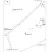
Lairhill NN 83 02 NN80SW 2
An alignment of five stones runs from NN 8307 0214 to NN 8330 0232, and includes the Wallace stone at NN 8324 0226; this is 1.8m high and is the only one still erect. One of the others is cup-marked.
RCAHMS 1979, visited September 1978
Name Book, Perthshire, no. 25, p. 91; Hutchison 1893, 123-4
Note (13 September 2019)
Date Fieldwork Started: 13/09/2019
Compiled by: Callander
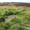
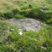
Location Notes: The Wallace Stone is the only remaining upright stone in a row of five, running SW-NE, each spaced about 75m apart. The row lies about 200m SE of the road between Bridge of Allan and Blackford, just about 0.5km WNW of the former Sheriffmuir Inn. The 2m high Wallace Stone is located second from the NE end of the row and is quite clearly visible. No rock art was identified on this stone. The previous notes remain broadly valid, though no further investigation of the other stones was done at this time other than to look for rock art. Cup marks were identified on the prostrate stone at the SW end of the row, and recorded as ScRAP id 2764, name Lairhill 1.
A summary of all stones in this row is:
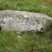
1. At SW end, NN 83081 02152, rock art recorded as Lairhill 1, ScRAP 2764.
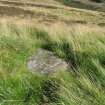
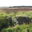
2. Second from SW, NN 83141 02194, which is split in two, 2.9m by 2.3 with 0.3m gap in middle, 0.9m high. No visible rock art.
3. Third from SW, NN 83197 02245, embedded in the ground, 1.7m by 1.1m on exposed surface. No visible rock art.
4. Wallace Stone, second from NE end, NN 83260 02286, 1.9m high, side widths 1.5m, 1.2m and 0.9m. No visible rock art.
5. AT NE end, NN 83311 02325, 3.0m by 1.9m, and 1.2m high. No visible rock art.

