Scotland's Rock Art Project (ScRAP)


Date 13 September 2019
Event ID 1118481
Category Descriptive Accounts
Type Note
Permalink http://canmore.org.uk/event/1118481
Date Fieldwork Started: 13/09/2019
Compiled by: Callander
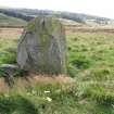
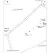
Location Notes: The Wallace Stone is the only remaining upright stone in a row of five, running SW-NE, each spaced about 75m apart. The row lies about 200m SE of the road between Bridge of Allan and Blackford, just about 0.5km WNW of the former Sheriffmuir Inn. The 2m high Wallace Stone is located second from the NE end of the row and is quite clearly visible. No rock art was identified on this stone. The previous notes remain broadly valid, though no further investigation of the other stones was done at this time other than to look for rock art. Cup marks were identified on the prostrate stone at the SW end of the row, and recorded as ScRAP id 2764, name Lairhill 1.
A summary of all stones in this row is:
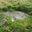
1. At SW end, NN 83081 02152, rock art recorded as Lairhill 1, ScRAP 2764.
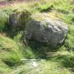
2. Second from SW, NN 83141 02194, which is split in two, 2.9m by 2.3 with 0.3m gap in middle, 0.9m high. No visible rock art.
3. Third from SW, NN 83197 02245, embedded in the ground, 1.7m by 1.1m on exposed surface. No visible rock art.
4. Wallace Stone, second from NE end, NN 83260 02286, 1.9m high, side widths 1.5m, 1.2m and 0.9m. No visible rock art.
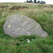
5. AT NE end, NN 83311 02325, 3.0m by 1.9m, and 1.2m high. No visible rock art.