
Pricing Change
New pricing for orders of material from this site will come into place shortly. Charges for supply of digital images, digitisation on demand, prints and licensing will be altered.
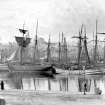
Peterhead Harbour, North Harbour


Harbour (Period Unassigned)
Site Name Peterhead Harbour, North Harbour
Classification Harbour (Period Unassigned)
Canmore ID 131043
Site Number NK14NW 128.02
NGR NK 13790 46200
NGR Description Centred NK 13790 46200
Datum OSGB36 - NGR
Permalink http://canmore.org.uk/site/131043


- Council Aberdeenshire
- Parish Peterhead
- Former Region Grampian
- Former District Banff And Buchan
- Former County Aberdeenshire
NK14NW 128.02 centred 1379 4620
Publication Account (2007)
North Harbour
The creation of this harbour stemmed from a proposal to give access to the South Harbour from the north and from Rennie’s proposals to enclose the area sheltered by Greenhill Island. From 1816–22 the first part of this harbour was built to plans proposed by Telford. These consisted of a
north breakwater, a graving dock on Greenhill Island, and quays along the southern and western perimeters of the harbour that provided an enclosed area of 11 acres.
Birnie’s and Scott’s piers were added later and in 1850 the previously mentioned short canal to the South Harbour was constructed. In 1975, when the northern entrance to the sea was closed, the overall depth of water in the harbour was 12 ft at low water ordinary spring tide.
R Paxton and J Shipway, 2007.
Reproduced from 'Civil Engineering heritage: Scotland - Highlands and Islands' with kind permission from Thomas Telford Publishers.

