
Pricing Change
New pricing for orders of material from this site will come into place shortly. Charges for supply of digital images, digitisation on demand, prints and licensing will be altered.
Tomatin Bridge


Road Bridge (Period Unassigned)
Site Name Tomatin Bridge
Classification Road Bridge (Period Unassigned)
Alternative Name(s) Tomatin, Findhorn Bridge; River Findhorn; Strathdearn
Canmore ID 76160
Site Number NH82NW 33
NGR NH 80822 29037
Datum OSGB36 - NGR
Permalink http://canmore.org.uk/site/76160


- Council Highland
- Parish Moy And Dalarossie
- Former Region Highland
- Former District Inverness
- Former County Inverness-shire
NH82NW 33 80822 29037
Location formerly entered as NH 808 290.
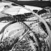
For corresponding railway viaduct (upstream, to SW), see NH82NW 28.
A9 Road Bridge.
(Undated) information in NMRS.
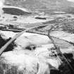
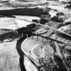
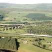
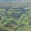
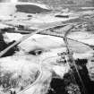
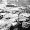
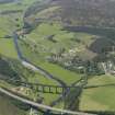
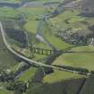
This bridge carries the present line of the A9 (T) public road over Strathdearn and the River Findhorn to the SE of Tomatin. It dates from the mid 1970's.
The location assigned to this record defines the midpoint of the structure; the river crosses under the viaduct some distance to the SE of this. The available map evidence suggests that it extends from NH c. 80771 29104 to NH c. 80892 28924.
Information from RCAHMS (RJCM), 23 March 2006.
Construction (1924 - 1926)
Designed by Sir Owen Williams in collaboration with architects Sir J. W. Simpson and Maxwell Ayrton and built from 1924–26 by Sir Robert McAlpine & Sons.
R Paxton and J Shipway, 2007.
Publication Account (2007)
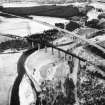
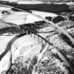
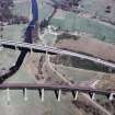
Findhorn Bridge, Tomatin
Historic Engineering Works no. HEW 1674
In the 1920s the road from Perth north to Inverness, subsequently the A9, was improved and widened, and a number of substantial bridges were constructed; Spey Bridge, Newtonmore and this bridge over the Findhorn,
south of Tomatin (4-44), being the largest. Both were designed by Sir Owen Williams in collaboration with architects Sir J. W. Simpson and Maxwell Ayrton and built from 1924–26 by Sir Robert McAlpine & Sons.
Findhorn Bridge, constructed of reinforced concrete, has twin spans of 98 ft with a roadway 30 ft wide that is carried on the lower booms of 18 ft deep parallel-sided girders somewhat of the Vierendeel type each pierced
with semi-hexagon al openings. This unusual design allows maximum waterway clearance below the spans during floods. The top booms of the girders, although appearing continuous, are broken over the central
support and at the abutments the girders rest on flexible columns permitting horizontal movement. The project formed part of a 78-mile improvement of the Great North Road from near Blair Atholl to Inverness from 1925–28; the most extensive since Telford’s time. These
works, including widening the carriageway from 12 ft to 18 ft using Telford’s hand-pitched foundation, and 61 bridges, were conducted under the direction of R. Bruce, chief engineer, cost £654 476. The works, paid for by government, were primarily undertaken to relieve unemployment, and also included a new road via Rannoch Moor and Glencoe (see Paxton, R and Shipway, J (2007), Civil Engineering Heritage Scotland – Lowlands and Borders, (item 5-39)).
R Paxton and J Shipway, 2007.
Reproduced from 'Civil Engineering heritage: Scotland - Highlands and Islands' with kind permission from Thomas Telford Publishers.

