
Pricing Change
New pricing for orders of material from this site will come into place shortly. Charges for supply of digital images, digitisation on demand, prints and licensing will be altered.
Scheduled Maintenance Notice
Please be advised that this website will undergo scheduled maintenance starting on Thursday, 30th January at 11:00 AM and will last until Friday, 31st January at 10:00 AM.
During this time, the site and certain functions may be partially or fully unavailable. We apologise for any inconvenience this may cause.
Invergordon, Royal Naval Dockyard, Control Tower


Control Tower (20th Century), Naval Signal Station (20th Century)
Site Name Invergordon, Royal Naval Dockyard, Control Tower
Classification Control Tower (20th Century), Naval Signal Station (20th Century)
Alternative Name(s) Cromarty Firth; Firth Of Cromarty
Canmore ID 300397
Site Number NH76NW 64.02
NGR NH 71184 68278
Datum OSGB36 - NGR
Permalink http://canmore.org.uk/site/300397


- Council Highland
- Parish Rosskeen
- Former Region Highland
- Former District Ross And Cromarty
- Former County Ross And Cromarty
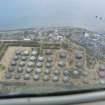
The naval base control tower occupies a site on the southern end of the East Pier. Its date of construction is not known but is thought to 1951 or later. On a plan of the building held in a private collection the building is named as a Signal Station.
It may be that the building controlled movements of all shipping and seaplanes in the Cromarty Firth.
Information from HS/RCAHMS World War One Audit Project (GJB) and (AKK) 2 August 2013.
NH76NW 64.02 71184 68278

