
Pricing Change
New pricing for orders of material from this site will come into place shortly. Charges for supply of digital images, digitisation on demand, prints and licensing will be altered.
Loch Mullardoch To Loch Beinn A' Mheadhoin Tunnel


Tunnel (20th Century)
Site Name Loch Mullardoch To Loch Beinn A' Mheadhoin Tunnel
Classification Tunnel (20th Century)
Alternative Name(s) Affric Hydro-electric Scheme; Glen Affric; Affric-cannich Hydro-electric Power Scheme
Canmore ID 171710
Site Number NH23SW 7
NGR NH 223 314
NGR Description From NH c. 223 314 to NH c. 248 265
Datum OSGB36 - NGR
Permalink http://canmore.org.uk/site/171710


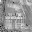
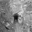
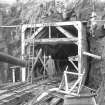
![View from road on centre line of tunnel outfall [NGR: 24862 26547] during construction work.
Copy of negative, Mullardoch-Fasnakyle-Affric, Box 1048/2, Contract No. 10, Plate No. 14.](http://i.rcahms.gov.uk/canmore/l/SC00869160.jpg)


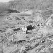
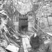
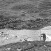
![View from T3 of Site of Mullardoch Tunnel Outfall [NGR: NH 24862 26547] prior to construction.
Copy of negative, Mullardoch-Fasnakyle-Affric, Box 1048/2, Contract No. 10, Plate No. 2.](http://i.rcahms.gov.uk/canmore/l/SC00869159.jpg)


![View from road on centre line of tunnel outfall [NGR: 24862 26547] during construction work.
Copy of negative, Mullardoch-Fasnakyle-Affric, Box 1048/2, Contract No. 10, Plate No. 14.](http://i.rcahms.gov.uk/canmore/s/SC00869160.jpg)


![View from T3 of Site of Mullardoch Tunnel Outfall [NGR: NH 24862 26547] prior to construction.
Copy of negative, Mullardoch-Fasnakyle-Affric, Box 1048/2, Contract No. 10, Plate No. 2.](http://i.rcahms.gov.uk/canmore/s/SC00869159.jpg)

- Council Highland
- Parish Kilmorack
- Former Region Highland
- Former District Inverness
- Former County Inverness-shire
NH23SW 7.00 NH c. 223 314 to NH c. 248 265 Loch Mullardoch to Loch Beinn A' Mheadhoin Tunnel
NH23SW 7.01 NH 22259 30960 Loch Mullardoch to Loch Beinn A' Mheadhoin Tunnel, Mullardoch Generating Station
Publication Account (2007)
In 1928 and 1941 hydro-schemes were proposed in Glen Affric. The first was turned down by Parliament and the second was dropped in favour of the more comprehensive Mullardoch–Fasnakyle–Affric project which was approved in 1947 and officially opened in 1952. A further stage to the north, developing the water power resources of the Beauly and its tributaries, the Strathfarrar and Kilmorack scheme, was carried out from 1957–63 and included the impressive 113 ft high double curvature arch dam at Loch Monar.
The main elements of the Affric scheme consist of Mullardoch Dam (NH23SW 1.00), a tunnel from Loch Mullardoch to Benevean, a small dam at Loch Benevean (NH22NE 5.01) and a tunnel from there to the main generating station at Fasnakyle in Strathglass (NH32NW 4.00).
Mullardoch Dam is 157 ft high and 2385 ft long and, with about 300 000 cu. yards of concrete, is the largest concrete gravity dam in Great Britain. It has two wings meeting at an angle of 1408 with the apex pointing downstream. Construction began in 1947 and two years into the work it was decided to raise the height of the dam by 20 ft, a change requiring great skill in its execution.
The dam has two spillways each 315 ft long and the level of the loch was raised by 112 ft to form a reservoir 8 1/2 miles long. Water from the reservoir is conveyed through a 14 1/2 ft diameter tunnel, 3 miles long, to Loch Benevean and onward to Fasnakyle Power Station where three 22 000kW
turbo alternators, with Francis-type turbines working under a gross head of about 520 ft, each develop 33 000 hp at 375 rpm.
The engineers were Sir William Halcrow & Partners and the main contractors, John Cochrane & Sons.
R Paxton and J Shipway, 2007.
Reproduced from 'Civil Engineering heritage: Scotland - Highlands and Islands' with kind permission from Thomas Telford Publishers.

