
Pricing Change
New pricing for orders of material from this site will come into place shortly. Charges for supply of digital images, digitisation on demand, prints and licensing will be altered.
Upcoming Maintenance
Please be advised that this website will undergo scheduled maintenance on the following dates:
Thursday, 30 January: 11:00 AM - 3:00 PM
During these times, some functionality such as image purchasing may be temporarily unavailable. We apologise for any inconvenience this may cause.
Raasay, Dun Borodale


Broch (Iron Age)(Possible), Galleried Dun (Iron Age)
Site Name Raasay, Dun Borodale
Classification Broch (Iron Age)(Possible), Galleried Dun (Iron Age)
Alternative Name(s) Vorodale; Voradel
Canmore ID 11457
Site Number NG53NE 1
NGR NG 55476 36337
Datum OSGB36 - NGR
Permalink http://canmore.org.uk/site/11457


First 100 images shown. See the Collections panel (below) for a link to all digital images.
- Council Highland
- Parish Portree
- Former Region Highland
- Former District Skye And Lochalsh
- Former County Inverness-shire
NG53NE 1 5547 3633
(NG 5547 3633) Dun (NR) Broch (NR)
OS 6" map, Inverness-shire, 2nd ed., (1904).
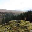
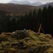
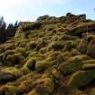
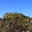
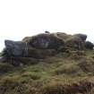
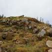
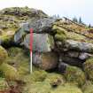
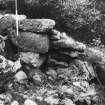
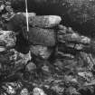
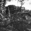
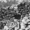
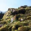
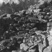
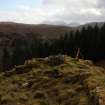
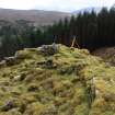
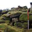
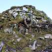
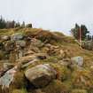
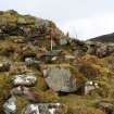
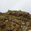
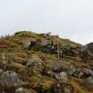
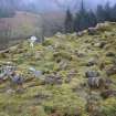
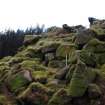
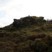
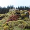
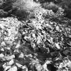
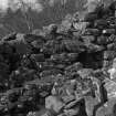
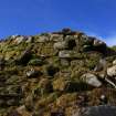
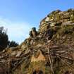
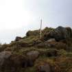
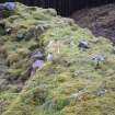
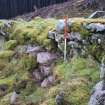
Dun Borodale or Voradel, an elliptical-shaped, broch-like structure, occupying a position of natural strength at an elevation of nearly 300' above sea-level. The whole of the eastern segment is so much broken down and the interior of the structure so much filled with debris that almost all details of ground level features are obscured. There are distinct traces of a passage 3' wide at its outer extremity on the E, and of a cell in the thickness of the wall at 6 1/2' S of the passage. The thickness of the walling varies from approximately 11' at the E, to 14' at the NW, and the outer face shows a very slight true batter and still remains to a height of 8 1/2' at the SE and SW. At two points, on the NW and SW, there are indications of a gallery above the level of the scarcement, averaging 15" in width and only about 18" above the debris. The scarcement extends along the inner face of the walling of the whole western segment. A small definite portion of the inner face of the gallery wall is apparent at the SW, but the indications of a like feature at the NW are not so pronounced. Immediately above the scarcement in the western section is a small crudely lintelled recess of almost 3' in width which may possibly indicate an entrance to a gallery (RCAHMS 1928). In 1870 it was possible to determine the internal measurements of this broch as 35' N-S by 24' high on the W side, but less elsewhere (Judd 1875). Confirmed as a Broch (Graham 1949).
(OS 1"map, 7th Series; RCAHMS 1928; J M Judd 1875; A Graham 1949).
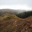
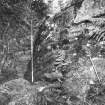
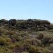
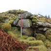
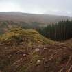
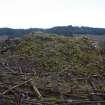
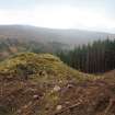
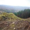
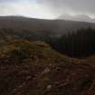
Dun Borodale, as described above, is in poor condition. Now within Forestry Commission land and difficult of access.
Visited by OS (A S P) 8 June 1961.
Field Visit (24 March 1926)
Dun Borodale, Raasay.
On a plateau on an eminence situated on the eastern fringe of Borodale Wood, about ¼ of a mile west of the Free Church Manse, is an elliptical-shaped broch-like structure called "Dun Voradel." The construction, which occupies a position of natural strength at an elevation of nearly 300 feet above sea-level, is composed of large stones with considerable infilling of smaller material, and lies with its main axis about 30 degrees east of magnetic north. The whole of the eastern segment is so much broken down and the interior of the structure so much filled with debris that almost all details of ground level features are obscured. There are distinct traces of a passage 3 feet wide at its outer extremity on the east, and of a cell in the thickness of the wall at 6½ feet south of the passage, but no precise measurements of the extent or size of these features could be secured. The thickness of the walling varies from approximately 11 feet at the east to 14 feet at the north-west, and the outer face shows a very slight true batter and still remains to a height of 8½ feet at the south-east and south-west. At two points, on the north-west and southwest, there are indications of a gallery above the level of a scarcement, averaging 15 inches in width and only about 18 inches above the debris. This scarcement extends along the inner face of the walling of the whole western segment. A small definite portion of the inner face of the gallery wall is apparent at the south-west, but the indications of a like feature at the north-west are not so pronounced. Immediately above the scarcement in the western section is a small crudely lintelled recess of almost 3 feet in width which may possibly indicate an entrance to a gallery, and a little to the north of this recess the face of the interior wall remains to a height of 6½ feet.
RCAHMS 1928, visited 24 March 1926.
OS map: Skye xxxv.
Field Visit (22 September 1971)
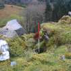
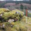
Dun Borodale, a semi-broch or oval dun exhibiting broch characteristics. It measures internally 11.4m N to S by 8.0m transversely within a wall varying between 4.2m and 3.2m in thickness, with an external batter. A well defined wall face in the thickness of the wall around the S arc has been interpreted by RCAHMS as the inner side of a gallery, but as there is no trace of a corresponding outer side, although this could have fallen away or be obscured by debris, it is more likely to be a stabilizing wall. A scarcement is visible around almost the whole of the S half. The entrance in the E is checked for a door and measures 0.9m in width externally and 1.5m internally. A cell to the S of the entrance is entered from within the dun and is partially collapsed. Opposite in the W arc is a similar entrance-way with a lintel, but it is choked with rubble and it cannot be established if it leads to a cell or gallery. The 1872 report of the wall being 20ft high on the W should be treated with caution. This is about the present height of the wall above the base of the knoll.
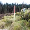
Some 12.0m to the NNW of the dun are traces of an overgrown boulder-faced outwork drawn across the easiest approach.
Surveyed at 1/2500.
Visited by OS (R L) 22 September 1971.
Publication Account (2007)
NG53 2 DUN BORODALE ('Dun Voradel', ‘Dun Voradale’, or 'Castle Vreokle')
NG/5547 3633
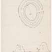
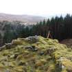
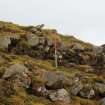
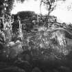
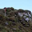
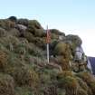
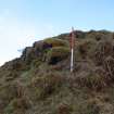
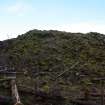
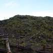
This broch on Raasay Island in Portree, Skye, is of markedly sub-circular if not oval form (visited in 1963, in 1971 and on 19/8/85). It stands on a rocky ridge on a hill at about 91m (300 ft) above the sea and in "a position of great natural strength" [3]. The ridge slopes sharply down on all sides except in the north. The building was planned as a pear-shape in 1926 [3] but a new survey in 1971 showed that the central court fits an ellipse accurately, and the whole broch is likely to be that shape; the long axis is aligned a little clockwise of north-south (10-190o,magnetic north) and along the spine of the ridge.
1. Description
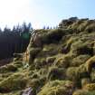
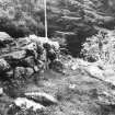
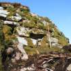
The easiest approach is along the spine of the ridge from the north, and here the wall is broken down and hidden under rubble. On the south-east and south-west arc the outer wallface, with a pronounced batter, still stands to a height of 2.55m (8.5 ft) (Illus. 8.000). The wallhead is about level so the underlying rock appears to be sloping downwards to the north, along the long axis of the structure. The entrance passage is on the east by south-east side – facing a steep slope – and is full of rubble; the outermost lintel appears to be only slightly dislodged and there is a massive, built door-check on the north (right) side 1.37m (4.5 ft) from the outside. The width of the passage is about 92cm (3 ft) and it appears to rise sharply towards the interior. Judd's comment that it is 2.14m (7 ft) wide at the inner end must be a mistake [3].
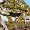
To the left, or south, of the entrance the rounded end of a mural gallery (thought to be a cell by the Commission [4]) can be seen in the wall and the sides of the doorway from this to the interior can be seen at 7 o'clock, about 1.98m (6.5 ft) from it; this door may well lead to the intra-mural stair. The gallery evidently continues round to the south-west – where it can be seen on the wallhead – and was noted in the north-west in 1926 [4]. This feature is above the level of a ledge-type scarcement which is visible along the whole of the west sector of the inner wallface and is about 38cm (15 in) wide. A small "crudely lintelled recess" was seen immediately above the scarcement on the west-north-west [1, 4] and may be a void or raised doorway to the mural gallery; it was not seen by the author. The scarcement was noticed in 1874, one of the earliest comments on this standard feature of the brochs [3].
In 1971 the Ordnance Survey's archaeological investigator mentioned that the outer face of the supposed mural gallery could not be seen and supposed that the inner face should be interpreted as a median face. This inner face is clearly visible at the south end where it stands three courses above the rest of the wallhead. The area immediately in front of it is grassed over so it cannot be said with certainty that no outer wall of a gallery exists.
There are traces of an overgrown, boulder-faced outwork crossing the spine of the ridge about 12m from the north end of the broch [1].
2. Structural analysis
The identification of Dun Borodale as a broch, though an oval one, seems straightforward; the conjunction of a scarcement ledge, a doorway of the appropriate design and signs of an intra-mural gallery on the wallhead above the scarcement would normally be quite sufficient to confirm its nature. The uneven nature of the rocky foundation of the site, and the scarcement which is level despite this (discussed below), also tend to confirm the identification.
Some basic levelling with an alidade in 1985 demonstrated beyond doubt that Dun Borodale is founded on sloping rock and that itmust be a hollow-walled broch. Two points on the scarcement on the south and west sides were levelled and proved to be within 5cm of the same height; thus the ledge, as is usual in brochs, appears to have been built horizontal despite the unevenness of the underlying rock. The scarcement is from 2.0 - 2.2m above the visible foot of the outer face on the south, which is concealed bymasses of heavy rubble and it could easily be 3.0m or more above the actual foot of the wall.
On the other hand the ledge is 1.05m below the visible base of the outer wallface at the north end, where there is also some fallen rubble against the outer face; the rock thus appears to descend about 4.0m from north to south over the length of the long axis, a distance of some 19.0m. The scarcement could be quite close to the rock at the north end, as at Caisteal Grugaig (NG82 1), and the north wall must have had at least two raised galleries inside it to have been any use at all.
In 1874 Judd recorded local inform-ation stating that some years before that the broch was better preserved and the “wall chambers” (presumably the intra-mural gallery) could be entered [2]. He also mentioned seeing the west narrow end as rising 6.1m (20 ft) above the ground (the rest being much lower), whereas at present the height of the outer face about 2.44m (8 ft). Even allowing for exaggeration Dun Borodale does seem to have been considerably better preserved a century and a half ago. It has been pointed out that the figure of 6.0m is about the present distance of the west wallhead above the base of the knoll, the implication being that Judd thought the wall went right down to the base of the knoll under the rubble; in this case the height in 1873 would have been much as at present. However Judd also said that the west end was higher than the rest, whereas it is now lower.
The site in 1695. The brief comment by Martin in about 1695 that 'Castle Vreokle' is "an Artificial Fort, three Stories high, ..." [2] not only supports the view that Dun Boroda1e was substantially higher only three centuries ago but also implies that three superimposed galleries were then visible in its wall.
3. Summary of architecture
The basic structure of Dun Borodale may have been as follows.
Level I: this seems to exist to its full height only at the southern end and is probably solid; as at Dun Ringill (NG51 4) it probably compensates for the lower surface of the rock here. Without system-atic excavation it cannot be determined whether the scarcement runs along the top of Level 1 but it seems probable; the ledge, as noted, could be close to the rock at the north end so that, as at Caisteal Grugaig (NG82 1), any wooden floor resting on it would also be close to the rock here but perhaps 2m or more above it at the southern end. The entrance on the south-east would be mainly in this Level and probably rises steeply, as at Dun Ardtreck (NG33 2). Whether there is enough room for the lintelled passage to be entirely within Level 1 is not clear. Likewise if the door to the mural stair is at about 7 or 8 o'clock it too is likely to be in Level I. On the other hand the possible void above the scarcement at 12 o'clock could be a raised door from a landing in the stair out to the wooden floor on the scarcement and, if so, the stair should start at about 10 o'clock.
Level 2 would then be the first tier of the normal galleried broch wall the base of which would be horizontal and at the level of the scarcement. Since this hollow part of the wall seems to be fairly close to the rock at the north end a second gallery, Level 3, can be confidently assumed to have existed on top of it if the wall had an adequate defensive height. Another, Level IV, was probably on top of that, as suggested by the early accounts [2, 3].
4. Shape and dimensions
Only the wall thickness – varying from 3.36m (11 ft) on the east to 4.27m (14 ft) on the west – is mentioned by the Commission. From their plan the longest and shortest overall diameters are 19.5m (64 ft) north-south and 16.17m (53 ft) east-west. In 1873 the internal measurements were given, inaccurately, as 10.68m (35 ft) north-south and 7.32m (24 ft) east-west [2]. In 1961 the equivalent internal measurements were determined as 11.4m north-south and 8.0m east-west and the wall was measured as from 3.2 - 4.2m thick [1].
A new survey of the interior wallface was carried out in 1971 (Illus. 8.141) and shows fairly convincingly that the central court was elliptical, with a long axis of c. 11.6m and a short axis of 8.3m. It is striking that 14 and 10 megalithic yards are, respectively, 11.606 and 8.29m.
The inner face below scarcement level (assumed to represent the shape at ground level) is only visible for about half of the circumference, and had evidently sagged inwards a little in several places (as at Dun Torcuill in North. Uist – site NF87 4); however the face above the scarcement continues round to the opposite side and confirms the elliptical shape.
Sources: 1. NMRS site no. NG 53 NE 1: 2. Martin 1994, 214: 3. Judd 1875, 308-09: 4. RCAHMS 1928, 181, no. 575 and fig. 255; 5. Graham 1948, 48-49: 6. Ritchie and Harman 1996, 125,
E W MacKie 2007
Management (2011)
Scheduled as 'Dun Borodale, dun 160m WSW of [the] Old Free Church Manse [NG53NE 112]... the remains of a fortified settlement site... visible as upstanding remains.'
Information from Historic Scotland, scheduling document dated 31 March 2011.
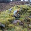
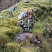
Field Visit (6 March 2012 - 7 March 2012)
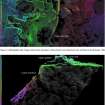
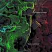
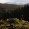
NG 55476 36337 A detailed survey was carried out 6–7 March 2012 on the galleried dun of Dun Borodale. Laser scanning was employed to create a detailed 3D model of the site, and traditional plans and sections were also produced.
Archive: RCAHMS
Funder: Forestry Commission Scotland
Graeme Cavers, AOC Archaeology Group
2012
Measured Survey (6 March 2012 - 7 March 2012)
An archaeological survey was carried out at Dun Borrodale, Raasay on behalf of Forestry Commission Scotland in March 2012. The site was laser scanned, interpreted detail was recorded and a photographic register compiled to accompany a detailed report.
Information from Graeme Cavers (AOC Archaeology) March 2012
OASIS ID: aocarcha1-122665

