Field Visit


Date 24 March 1926
Event ID 1105078
Category Recording
Type Field Visit
Permalink http://canmore.org.uk/event/1105078
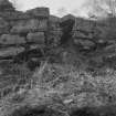
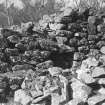
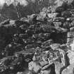
Dun Borodale, Raasay.
On a plateau on an eminence situated on the eastern fringe of Borodale Wood, about ¼ of a mile west of the Free Church Manse, is an elliptical-shaped broch-like structure called "Dun Voradel." The construction, which occupies a position of natural strength at an elevation of nearly 300 feet above sea-level, is composed of large stones with considerable infilling of smaller material, and lies with its main axis about 30 degrees east of magnetic north. The whole of the eastern segment is so much broken down and the interior of the structure so much filled with debris that almost all details of ground level features are obscured. There are distinct traces of a passage 3 feet wide at its outer extremity on the east, and of a cell in the thickness of the wall at 6½ feet south of the passage, but no precise measurements of the extent or size of these features could be secured. The thickness of the walling varies from approximately 11 feet at the east to 14 feet at the north-west, and the outer face shows a very slight true batter and still remains to a height of 8½ feet at the south-east and south-west. At two points, on the north-west and southwest, there are indications of a gallery above the level of a scarcement, averaging 15 inches in width and only about 18 inches above the debris. This scarcement extends along the inner face of the walling of the whole western segment. A small definite portion of the inner face of the gallery wall is apparent at the south-west, but the indications of a like feature at the north-west are not so pronounced. Immediately above the scarcement in the western section is a small crudely lintelled recess of almost 3 feet in width which may possibly indicate an entrance to a gallery, and a little to the north of this recess the face of the interior wall remains to a height of 6½ feet.
RCAHMS 1928, visited 24 March 1926.
OS map: Skye xxxv.