
Pricing Change
New pricing for orders of material from this site will come into place shortly. Charges for supply of digital images, digitisation on demand, prints and licensing will be altered.
Upcoming Maintenance
Please be advised that this website will undergo scheduled maintenance on the following dates:
Thursday, 9 January: 11:00 AM - 3:00 PM
Thursday, 23 January: 11:00 AM - 3:00 PM
Thursday, 30 January: 11:00 AM - 3:00 PM
During these times, some functionality such as image purchasing may be temporarily unavailable. We apologise for any inconvenience this may cause.
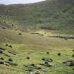
St Kilda, Hirta, An Lag Bho'n Tuath


Cairn(S) (Period Unassigned)(Possible), Cleit(S) (Post Medieval)(Possible), Stone Setting(S) (Neolithic) - (Bronze Age)(Possible)
Site Name St Kilda, Hirta, An Lag Bho'n Tuath
Classification Cairn(S) (Period Unassigned)(Possible), Cleit(S) (Post Medieval)(Possible), Stone Setting(S) (Neolithic) - (Bronze Age)(Possible)
Alternative Name(s) Cottam 6 And 8; Hirta 2022 And 2023
Canmore ID 83041
Site Number NF19NW 25
NGR NF 10288 99561
Datum OSGB36 - NGR
Permalink http://canmore.org.uk/site/83041


- Council Western Isles
- Parish Harris
- Former Region Western Isles Islands Area
- Former District Western Isles
- Former County Inverness-shire
Excavation (1993)
NF19NW 25 1020 9950
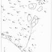
At An Lag Bho'n Tuath the first season of excavation concentrated on a pair of stone settings (NF 1020 9950) recorded by earlier surveys. These features perhaps unfortunately termed 'boat-shapes', appear to represent the central settings of sub-circular cairns. A series of kerbs were visible within the larger of the two cairns, which lay immediately NW of its neighbour. The two cairns appear to be joined and it is possible that the more substantial of the two was constructed later, perhaps including material robbed from the earlier structure. In the central area of the larger cairn were traces of various pits and cuts, some of which appear to run beneath the stone setting and cairn. No finds were recovered from the central area, but several coarse stone tools, including what may be ard tips were recovered from the matrix of the smaller cairn. These cairns and stone settings may represent funerary monuments but further excavation will be required before such an interpretation can be verified.
A Morrison, P Johnson and A Pollard 1993.
Excavation (1994)
The excavation of the pair of stone settings was completed in 1994. These 'boat shape' features were seen in 1993 to represent the central settings of sub-circular cairns. The sites had a shallow covering of grass, sphagnum, heather and peaty soil and the two settings appeared to be joined by the stone 'platform' which surrounds them. The 1994 season showed that the sites were more complex than had been previously realised, with traces of pits and cuts, first noted in 1993 in the central area of the larger of the two settings, appearing to run beneath the stone settings and 'platform' material in the old land surface. The form of the settings would suggest perhaps burial or some ritual connected with it, but the highly acidic nature of the thin soil derived from the granophyre geology and the constant flooding of the site makes it unlikely that any organic remains would survive.
Sponsor: National Trust for Scotland
A Morrison, T Pollard and J Huntley 1994.
Field Visit (8 September 2007)
[2022 ] A robbed cleit surviving as a small oval setting of boulders, with the grounders of the inner and outer faces still visible on the E side.
[2023] A setting of two roughly parallel rows of stones and boulders situated on the bedrock ground surface.
Visited by RCAHMS (JRS) 8 September 2007.

