
Scheduled Maintenance
Please be advised that this website will undergo scheduled maintenance on the following dates: •
Tuesday 3rd December 11:00-15:00
During these times, some services may be temporarily unavailable. We apologise for any inconvenience this may cause.
Kilphedir


Broch (Iron Age)
Site Name Kilphedir
Classification Broch (Iron Age)
Alternative Name(s) Kilphader Tower
Canmore ID 7000
Site Number NC91NE 27
NGR NC 9943 1891
Datum OSGB36 - NGR
Permalink http://canmore.org.uk/site/7000


- Council Highland
- Parish Kildonan
- Former Region Highland
- Former District Sutherland
- Former County Sutherland
NC91NE 27 9943 1891.
(NC 9943 1891) Broch (NR)
OS 6" map, 1964.
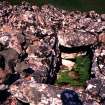
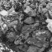
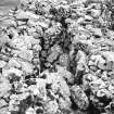
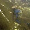
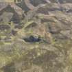
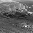
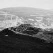
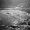
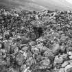
Situated on the summit of a hillock is a broch measuring 33' NE-SW by 32' transversely, within a wall 7' average height and 12'6" thick, widening to 15'6" at the entrance which is 3' wide at the exterior, and 4'10" at the interior It is checked for a door, but no entrance to a guard chamber is visible. Opposite the entrance there is a passage giving access to the stairway and a ground floor mural chamber.
The commanding position of the broch is strengthened by outworks, probably the most impressive in Sutherland. The base of the hillock is encircled by a ditch 9' deep below an outer rampart 14' broad. A short outer ditch runs parallel with the inner one for about 20' at the N end. A small oval enclosure is contained in the outer rampart to the W side of the broch. The course of the ditch is broken on the N side by the approach which passes between its open ends.
A quartzite pebble from the broch is in Dunrobin Museum Acc No: 1869.5 (Information from TS of Catalogue of Dunrobin Museum, by A S Henshall).
J M Joass 1865; J Nicol 1910; RCAHMS 1911, visited 1909; R W Feachem 1963; A Young 1964; E W MacKie 1975.
This broch has remained unaltered since the visit by the RCAHMS.
Re-surveyed at 1:10560
Visited by OS (W D J) 20 May 1960 and (N K B) 6 October 1976.
Publication Account (1995)
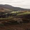
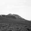
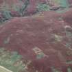
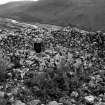
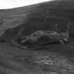
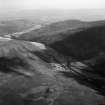
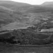
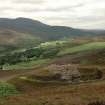
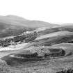
The broch is on the hill east of the burn but cannot be seen from the road by the bridge. A sheep track just east of the bridge leads up the hill, bearing slightly right, and passes through a deserted crofting settlement under the line of the electricity poles; there are the foundations of a longhouse, and some smaller buildings and a kiln barn. From the first skyline the broch is visible on the hillside above, some 15 or 20 minutes walk from the road.
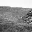
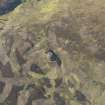
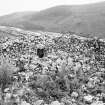
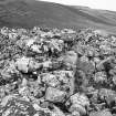
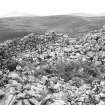
The broch is set on a prominent knoll with good views up and down the valley. It is ruinous, and appears as a great mass of rubble spilling down the hill, but it has a particularly impressive set of outer defences, now all covered with heather so that the stone walls look like banks. There are terraces east and west of the broch defended by an inner rampart, a deep ditch and a stout outer rampart. At the west end, the entrance is protected by an extra short stretch of rampart.
Just below the broch is a good path along the side of the hill; follow it west to find three hut circles on the edge of the ravine above the burn (NC 991190). One hut circle has much thicker walls than the other two, and this one has a souterrain leading out of it beneath its wall. The far end has been broken into, so light comes in, but it may be full of water and gumboots are needed. A muddy hole, originally provided with steps, drops down into the narrow souterrain passage; the latter has drystone walls and a lintelled roof and is about 9.50m long.
There are more hut circles up the burn and on the west bank. Some of the latter were excavated in the 1960s, and shown to have interior posts that supported their thatched roofs, whi le radiocarbon dates from two huts suggest they were occupied in the last few centuries BC. A number of clearance cairns round these and other hut circles are probably of the same date and show that some patches of ground were cultivated. Many other hut circles can be seen on the hill slopes along the north side of the Strath of Kildonan, some indicated onthe OS map, and at least six other souterrains have been found, three still attached to hut circles. Part of one at Suisgill (NC 897250) is close to the east side of the road; only the far end survives, with lintelled roof and a curved end-wall, in which is a small built-in recess or cupboard .
Information from ‘Exploring Scotland’s Heritage: The Highlands’, (1995).
Publication Account (2007)
NC91 7 KILPHEDIR ('Kilphader Tower')
NC/9943 1891
This probable broch in Kildonan stands high up on the moor overlooking the valley of the river Helmsdale, with a clear view up and down the strath (visited 12/7/63). It stands on a natural knoll which has been entirely surrounded at its base by a formidable ditch 2.75m (9ft) deep within an earthen rampart 4.27m (14ft) wide. There is a short outer ditch, parallel with the inner and about 6.10m (20ft) long, at the north end, facing the river where the approach is over flat ground. On the south-west a causeway crosses the main surrounding ditch and Swanson describes a ramp on the north-west which she thinks was the main approach to the broch[8].
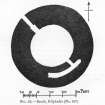
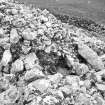
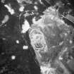
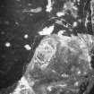
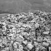
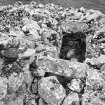
The broch itself is almost completely hidden under a vast pile of stones which look as though they have never been disturbed. Several features are visible however. The entrance is on the north-west (facing the ramp) with three lintels still in position: it is 4.73m (15.5ft) long, 92cm (3ft) wide at the outer end, 1.48m (4ft 10in) at the inner and with 15cm (6in)-deep door-checks at a distance 3.05m (10ft) in; these are presumably built rebates but were not noted by the author in 1963, though Swanson saw the one on the right [8, 780]. No signs of a guard cell are visible.
At 12 o'clock can be seen the doorway from the interior to an intra-mural gallery which probably contains the stair: this was in fact seen here, together with a stair-foot guard cell, in 1909, but there were no signs of the steps in 1963 even though the gallery – 76-92cm (2.5 - 3ft) wide – is exposed down to 61cm (2ft) below the present wallhead. A short stretch of the inner face of a mural gallery is visible at 10 o'clock but no signs of a scarcement ledge are apparent on the interior wallface. Three lintels are in position over the gallery in the arc from 2-5 o'clock. A quartzite pebble from the broch was in the collection of the Dunrobin Castle Museum [1].
This is another site which seems to have been somewhat better preserved in the recent past. Stuart visited it in about 1866 and stated that "The present example has walls of about fifteen feet in thickness, containing chambers which enter from the central open space." He also noted that "A flight of stairs, formed of flags in the centre of the wall, is yet entire." [7, 290]. The drawing from the early 1860s shows this better preservation well.
Dimensions: the broch's internal diameter is 10.07m (33ft) from north-east to south-west (on the 6-12 o'clock axis) and 9.76m (32ft) transversely. Swanson gives it as 9.6m north-south [8]. The wall thickness at the entrance is 4.27m (14ft) (4.73m, or 15.5ft, according to the Commission) and the total diameter here is 18.15m (59.5ft): the wall proportion would thus be 45.5%.
Sources: 1. NMRS site no. NC 91 NE 27: 2. Joass 1864, 246: 3. RCAHMS 1911a, 104-05, no. 307, fig. 35 and pl. III: 4. Young 1962, 186: 5. Feachem 1963, 173: 6. MacKie 1975, 218: 7. Stuart 1868: 8. Swanson (ms) 1985, 779-82: 9. Close-Brooks 1995, 152-3, no. 84: 10. Armit 2003, 36, 80: 11. Dockrill 2002, 160.
E W MacKie 2007
Note (7 February 2015 - 18 October 2016)
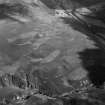
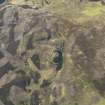
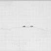
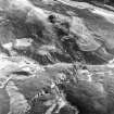
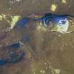
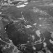
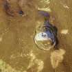
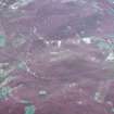
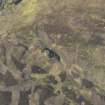
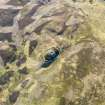
The Kilphedir broch is situated in a commanding position overlooking the Strath of Kildonan, occupying the crest of a hillock high up on the northern flank. Around the foot of the hillock, however, there is also a substantial earthwork comprising a ditch up to 6m in breadth, with a counterscarp rampart standing up to 2.5m above its bottom. In places, particularly around the eastern half of the circuit, there are also traces of a bank on the inner lip of the ditch, but this detaches itself from this line on the SE and appears to be forming a smaller enclosure on the crest of the hillock. A gap in the ditch on the NW marks the position of the entrance, and is flanked on the E by a short length of an outer ditch with a counterscarp bank. The area enclosed measures about 60m from NNW to SSE by up to 32m transversely (0.16ha), though aerial photographs suggest that there may also be a rather smaller enclosure occupying the crest of the hillock. The interior around the broch is otherwise featureless. The broch itself, which is largely choked with rubble, measures about 10m in diameter within a wall about 4.3m in thickness, its features including a gallery on the S and a checked entrance passage on the NW.
Information from An Atlas of Hillforts of Great Britain and Ireland – 18 October 2016. Atlas of Hillforts SC2797

