
An Dun


Promontory Fort (Period Unassigned)
Site Name An Dun
Classification Promontory Fort (Period Unassigned)
Canmore ID 6851
Site Number NC86NE 2
NGR NC 8566 6626
Datum OSGB36 - NGR
Permalink http://canmore.org.uk/site/6851


- Council Highland
- Parish Farr
- Former Region Highland
- Former District Sutherland
- Former County Sutherland
NC86NE 2 8566 6626.
(NC 8566 6626) An Dun (NR)
OS 6"map, (1964)
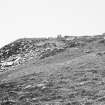
An Dun: On a slight promontory some 200ft above the sea are the indefinite foundations of a fort or castle. A parapet, some 6ft thick, has been built round the edge of the cliff, and about 15ft back from it, at the centre of the curve, are the foundations of a structure measuring internally about 20ft by 8ft. The purpose of this structure is unknown. RCAHMS 1911, visited 1909.
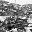
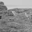
An Dun, the fragmentary remains of a dun, roughly oval on plan, measuring about 13.0m NW-SW by 9.5m transversely within a wall some 3.0m thick reduced to a low stony scarp. The base course of the inner face is visible intermittently in the N and W, and traces of the outer face, with one fragment surviving to a height of 4 courses and 0.6m, are visible in the SW. The entrance is not evident. The remains of a presumably later subrectangular structure occur inside the dun. Marked by a slight stony bank with six upright stones, tallest 0.9m along its sides, it measures about 7.5m E-W by 5.0m transversely.
Outside the dun in the SE is an outwork in the form of a denuded rampart 0.6m high and spread to 3.5m.
About 15m SW of the dun on a shelf at a lower level are traces of stone-walled structures of uncertain plan and date.
Surveyed at 1:2500.
Visited by OS (W D J) 3 May 1960 and (A A) 8 November 1960.
No change to the previous field reports.
Visited by OS (J M) 7 July 1977.
A cliff-castle.
R J Mercer 1981.
Note (6 February 2015 - 31 May 2016)
This small fortification is set on a promontory formed where a narrow spur extends out NNW into an angle in the coastal cliff-line. Thus the ground falls away precipitously on the E and N, but merely descends in a steep slope along the W margin, while access along the relatively level approach on the crest of the spur is barred by an earthen rampart with an external ditch. This cuts off an area measuring about 25m from NNW to SSE by 15m transversely (0.03ha), most of which at the seaward end is occupied by what are evidently substantial stone structures, possibly representing several phases of construction. One element is possibly an oval dun, but the upright stones protruding through the turf in the middle of the interior suggest that another is an aisled structure akin to the wags of Caithness.
Information from An Atlas of Hillforts of Great Britain and Ireland – 31 May 2016. Atlas of Hillforts SC2789

