
Pricing Change
New pricing for orders of material from this site will come into place shortly. Charges for supply of digital images, digitisation on demand, prints and licensing will be altered.
Upcoming Maintenance
Please be advised that this website will undergo scheduled maintenance on the following dates:
Thursday, 9 January: 11:00 AM - 3:00 PM
Thursday, 23 January: 11:00 AM - 3:00 PM
Thursday, 30 January: 11:00 AM - 3:00 PM
During these times, some functionality such as image purchasing may be temporarily unavailable. We apologise for any inconvenience this may cause.
Lewis, Dun Bharabhat


Broch (Iron Age), Causeway (Iron Age), Galleried Dun (Iron Age), Midden (Iron Age)
Site Name Lewis, Dun Bharabhat
Classification Broch (Iron Age), Causeway (Iron Age), Galleried Dun (Iron Age), Midden (Iron Age)
Alternative Name(s) Dun Baravat; Loch Baravat
Canmore ID 4020
Site Number NB03NE 4
NGR NB 09886 35325
Datum OSGB36 - NGR
Permalink http://canmore.org.uk/site/4020


- Council Western Isles
- Parish Uig
- Former Region Western Isles Islands Area
- Former District Western Isles
- Former County Ross And Cromarty
NB03NE 4 09886 35325
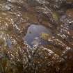
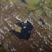
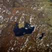
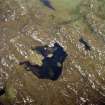
(Area: NB 098 353) The remains of a circular dun occupy the greater part of a small island which lies about 70' from the extremity of a promontory on the western side of Loch Baravat.
The building rises from the Water's edge on all sides except on the east where the edge of the loch is about 12' distant. The dun was much dispoiled about 1911 for the building of an adjoining sheep fank and dipper. The outer face of the wall can be traced for about two- thirds of the circumference, but is quite obliterated on the north, while on the landward side, where it is best preserved, a short section rises to a height of 3' above the surface of the water.
Overall the dun measures 37' in diameter. The interior is filled with fallen stones, the mound thus formed rising to a height of 6'. In no place can the inner face of the wall be traced, and the doorway is now obliterated, but on the east side are several long slabs like lintels.
A causeway, with stepping stones on its summit, connects the dun with the land to the east, but it is impossible to say whether or not this has been made in recent times to facilitate the removal of stones for building.
RCAHMS 1928, visited 1914.
This dun, at NB 0987 3530, is oval not circular. The outer wall-face is visible for most of the periphery, rising to a maximum height of four courses on the W side giving an overall measurement of 10.0m E-W by 11.6m transversely. The entrance, filled with tumble, is visible in the E. No trace of the inner wall face can be seen. The causeway is probably contemporary.
Divorced survey at 1/10,000
Visited by OS (R L) 6 June 1969.
Field Visit (8 July 1914)
Dun, Loch Baravat, Kneep.
Some 70 feet from the extremity of a promontory on the western side of Loch Baravat, Kneep, near Valtos, a small loch, about 100 feet above sea-level, surrounded by rugged stony hills, are the remains of a circular dun, occupying the greater part of a small island. The building rises from the water's edge on all sides, except on the east, where the edge of the loch is about 12 feet distant. The dun was much despoiled some three years ago to provide stones for an adjoining sheep fank and dipper. The outer face of the wall can be traced for about two thirds of the circumference, but it is quite obliterated towards the north, while on the landward side, the west, where it is best preserved, a short section rises to a height of 3 feet above the surface of the water. Over all, the dun measures 37 feet in diameter. The interior is filled with fallen stones, the mound thus formed rising to a height of 6 feet. In no place can the inner face of the wall be traced, and the doorway is now quite obliterated, but on the east side are several long slabs, like lintels. A causeway, with stepping stones on its summit, connects the dun with the land to the east, but it is impossible to say whether this has not been made in recent times to facilitate the removal of stones for building.
RCAHMS 1928, visited 8 July 1914.
OS map: Lewis xvii (unnoted).
Excavation (1985)
Excavation of the S quadrant demonstrated the presence of broch-like features including an entrance complete with a door check and barhole, an inter-mural gallery and the first seven steps of an intra-mural staircase. In the interior, a hearth with flagged surround and the remains of an internal partition comprised of a row of cobbles were recovered. At least three major phases of occupation are represented. Artefacts recovered from the excavation included pottery with typical Hebridean later prehistoric decoration, probable small metal or glass working crucibles, animal bones, shells of several marine species and fragments of cut wood.
D W Harding, P G Topping and T N Dixon 1985.
Excavation (1986)
The site is approached by means of a causeway around 20m long leading out from the W shore of the loch. The dun measures overall approximately 10m SE-NW and 11.5m NE-SW. Its inner and outer walls are on average a metre thick, with a gallery space between of similar width. Removal of surface rubble in 1985 and 1986 very rapidly established the existence of three principal galleries, and a fourth cell adjacent to the dun entrance. The main entrance was over a metre wide at its outer end widening to approximately 1.4m immediately behind the door rebates. A pivot stone indicated the position of the swinging door itself, and two bar holes were contained within the flanking walls on either side. The floor of the entrance was paved, providing a link between the internal stratigraphic sequence and the external paving of the annexe.
The area so far exposed in the interior has produced relatively few internal fittings or furnishings. The centre of the dun, at any rate in its later phases of occupation, was dominated by a hearth of baked clay, defined by edge-set stones, and based upon a raft of hard green clay.
An additional setting of stones just offset from the centre of the dun is also secondary, but there is some evidence that earlier hearths may lie below these features.
One noteworthy feature of the secondary occupation was the discovery around the NW side of the central hearth of an arc of animal teeth, disarticulated from any trace of jaw bones, and disposed individually in a line, or double line for a distance of 60cms to 70cms within the excavated area.
Directly outwith the entrance to the dun a cutting 2m wide down to the water's edge exposed structural evidence for the use of the Annexe. A short length of cross wall, 1.0m thick and 1.20m from the dun wall, evidently provided protective cover for the dun entrance. Beyond the cross wall, by the water margin, a hearth like feature was defined by a series of edge set stones, while stone facing in the edge of the trench suggested a concentration of structures in the Annexe.
The benefits of the underwater excavation in the surrounding loch has been immediately evident from the volume of material recovered from a relatively small area, and from the fact that this material complemented rather than supplemented the finds from the land based excavation. Animal bone, barely recoverable from the interior, is preserved in quantity underwater, while shells, which were equally scarce within the dun, occur frequently in the underwater deposits. The 1986 excavation also exposed a length of walling, five courses high, and not obviously displaced, the footings of which sit nearly a metre below present water level.
Several decorative features within the pottery assemblage can be paralleled elsewhere, notably applied cordons, ring bosses, averted rims and incised linear decoration, but definition within the typology is not well established.
D W Harding, P G Topping and T N Dixon 1986
Publication Account (2007)
NB03 1 DUN BHARABHAT 1 ('Loch Baravat', 'Dun Baravat 1')
NB/0987 3530
This probable ground-galleried broch or massive gallery-walled round-house, together with submerged dun or roundhouse close by, in Uig, Lewis, are both situated on an small islet in a loch, about 21m (70 ft) from the end of an adjacent promontory and connected to it by a causeway (excavation visited in June 1985).
1. Introduction
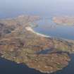
Loch Baravat itself is about 30m (100 ft) above sea level and is surrounded by low stony hills [3, Plate 1]. A shallow ravine leads down from the surrounding ground towards the lower ground and the sea. The name of the loch evidently comes from the Norse 'Borgarvatn', meaning 'lake of the stronghold' (Thomas 1890, 388).
The land structure was originally classified as an island dun [2] but excavations by the Dept. of Archaeology, University of Edinburgh, from 1985-87 revealed that it was a gallery-walled broch or massive roundhouse; the term preferred by the excavator is “complex Atlantic roundhouse” (see Section 6.5 above). The explorations also revealed a succession of submerged smaller stone roundhouses next to the islet, which produced a large quantity of implements of wood as well as valuable environmental evidence. These structures were thought at first to be somewhat older than the building on the islet but the whole complex was probably occupied simultaneously. Certainly the material culture in both areas was similar, the pottery in particular being indistinguishable.
The work at Dun Bharabhat is of considerable significance because the true nature of the 'broch' or 'roundhouse' itself was not seen until excavation started. It turned out to be a somewhat anomalous structure which does not fit clearly into the standard categories of Hebridean Iron Age buildings and thus emphasises the point made by the excavator [3, 102 ff], and also in Section 6.5 above; there is a much greater variety of broch-like sites in the western maritime part of the Atlantic Province than on the mainland and the northern islands. The date of the building and of the associated material culture is clearly of first importance and has been pinned down reasonably well – though perhaps not as well as one would like – by radiocarbon measurements (below).
Another reason for the importance of Dun Bharabhat is that it has given us a new insight into the economy and organisation of an Iron Age island round-house and its community. If the extensive underwater excavations had not been carried out we would have no idea that the roundhouse had an annexe to it which was used for a variety of purposes, and little idea of the range of artifacts of organic materials which were used therein. One wonders how many other island brochs and duns had these outlying buildings, now submerged.
The first part of the excavation report has appeared [3]. However this entry gives a fairly detailed summary of the most important information therein, firstly because the site is important as explained, and secondly because the report is a publication of the Dept. of Archaeology in Edinburgh and may not be widely available outside Scotland. Only a selection of the pottery found is illustrated here.
2. The roundhouse
2.1 The structure
The oval building rises from the water's edge on all sides except on the east where there is about 3.6m (12 ft) of ground (it was in this wider area that the submerged structures were found). Much damage was done to the main building when a sheep dip was built nearby in about 1911 [2], but signs of the collapse of part of the wall in ancient times were also observed. No intra-mural features were noted before the excavations began. A causeway paved with stepping-stones connects the island with the shore to the east.
The roundhouse [4, frontispiece] encloses an oval area measuring 10.0m east/west by 11.5m north/south and has its entrance passage facing east, on the opposite side to the causeway (it is assumed that some kind of raised dry path ran round from the latter to the entrance). This passage is 1.0m wide at the exterior and has two built door-checks, with a sill stone in the floor between them, 0.8m from the exterior; behind the door-frame the passage widens to 1.4 m. The floor is paved – the paving extending into an outer forecourt – and a pivot stone was found behind the right check (most are on the opposite side), with bar-hole and socket in the wall above. The wall contains a series of short galleries (about 1.0m wide) and a stairway, suggesting that Dun Bharabhat is a ground-galleried broch. However with an average thickness of 3.0m it is relatively thin for a broch tower, though not uniquely so.
At 7.30 o'clock is the doorway to Gallery 1, 90cm wide at the inner end, which contains the stair of which seven steps remain [3, Plate 3]; a slight recess to the left of the doorway suggests a rudimentary stair-foot guard cell, and here there were several apparent stone lintels which had fallen to the floor when the outer half of the wall sagged outwards. At 12 o'clock is the 1.6m- wide doorway (widening to 2.0m) to Gallery 2 but the whole of this section runs anti-clockwise to behind the stair. The doorway is so wide that it must surely have been widened during a secondary stage of occupation and after the upper parts of the wall had collapsed or been removed.
At 3 o'clock is the narrow doorway, with its lintel still in position, to Gallery 3 which also runs only anti-clockwise from it, and looks rather like an elongated cell; it contained several stone lintels which had collapsed downwards [3, Plate 4]. This seems to imply the existence of at least one upper gallery in the original structure. At 4.30 o'clock is the 1.5m wide doorway, with a fallen lintel [3, Plate 5], to a large rectangular cell which the excavator thought might have been inserted into Gallery 3; indeed the outer wallface of this gallery was found to extend towards this cell [3, fig. 3] and the cell seems to have been taken back into part of the outer wall of the roundhouse. Here again this could only have been done if the original high wall had been taken down.
The floor of the central court was of earth, based on a foundation of rough boulders; there was no trace of internal paving. A round hearth of baked clay was found in the centre of the enclosed area and had had a stone kerb added to it during the secondary phase of occupation. No scarcement was found on the inner wallface but the poor state of preservation means that there may have been one higher up. Neither were there any clear signs of a raised doorway in the wall to which the stair might have led, and no post-holes in the interior are described. The evidence for that typical broch structural feature – the annular raised wooden floor resting on the stone ledge and on a ring of posts – is thus absent at this site.
There was abundant evidence that parts of the stone wall of the roundhouse had collapsed because of poor foundations. As noted the secondary changes to the stonework – notably the insertion of the rectangular cell to the right of the entrance and the widening of the doorway to Gallery 2 – presumably occurred at this time.
2.2 The occupation layers
The stratigraphy of the layers of the central court revealed at least three phases of occupation, the oldest of which pre-dated the roundhouse. This consisted of an extensive layer of black, peaty soil overlying a raft of cobbles; several lenses of red or orange in this were found to extend under the roundhouse wall. Waterlogging during the excavations inhibited a full exploration of this stratum which the excavator thought could either represent a pre-roundhouse occupation or activity related to the construction of the latter. A C-14 date was obtained for this level of –
2550 +/- 50 bp (GU-236)
and this calibrates to 820-520 BC at a 95.4% level of confidence [3, Table 1]. No finds came from this layer.
The next layer up was the primary occupation layer, resting on a platform of hard green clay which equated with the small area of paving extending inwards from the entrance. The layer itself was of dark earth which contained small potsherds, occasionally large numbers of them, which may have been crushed and thrown down to harden the floor layer. This horizon was not a single, uniform layer all over the interior but its nature seemed clear [3, 22-5 and figs. 10 and 11]. The clay central hearth was laid in this phase.
The second and final major habitation layer was the most obvious of the occupation strata in the roundhouse interior and the clearest element of this was a burnt layer – including many charred timbers – which signalled the destruction of the site at the end of its Iron Age use. The impression gained was that the timber roof frame had caught fire and collapsed into the interior and this and other aspects of the horizon are discussed in detail in the report [3, 20-2]. An important point is that this secondary occupation layer overlapped in places the slumped or partially collapsed wall of the original building. Two C-24 dates were obtained for charcoal from the destruction layer.
2100 +/- 50 bp (GU-2435
2010 +/- 50 bp (GU-2434)
These calibrate, first, to 200-50 BC at 10% probability or 250 BC - AD 10 at 90% probability and, second, to 100 BC - AD 30 at 68.2% probability.
A layer of earth was found in places on top of the destruction layer, and below the final collapse of rubble, and suggests that the building was used intermittently for some purpose when it was a roofless shell.
Site sequence. For convenience the sequence of occupation phases in Dun Bharabhat is here numbered; the correlation between these numbers and the excavator's terminology is –
Primary occupation (pre-roundhouse): Phase 1
Main or primary roundhouse occupation: Phase 2
Secondary (roundhouse) occupation: Phase 3a
End of secondary occupation – destruction: Phase 3b
Late Secondary occupation: Phase 4
Post-abandonment: Phase 5
2.3 The non ceramic finds
The catalogue of finds simply gives a Context for each; they are not grouped into the main phases of occupation just described, though this can be worked out by consulting the list of Contexts [3, 52-3]. Here the most important finds are grouped by Phase. The pottery is indistinguishable from that obtained in the submerged buildings so is discussed all together below, in Section 5.
Phase 1
Stone: 1 spindle whorl (070) with a flattened oval cross-section, diam. 42mm [3, fig. 14, no. 1].
Phase 2
Glass: 1 small ring bead of blue translucent glass (050), diam. 7mm.
Stone: 1 pebble hammerstone (087).
Phase 3a
Copper alloy working: 1 crucible (030).
Glass: 1 small ring bead of blue translucent glass (036), diam. 6mm: 1 small ring-bead of yellow glass, diam. 4mm: 1 fragment of red and yellow opaque glass bead (068) with approx. D-shaped cross-section, diam. 18mm.
Amber: 1 fragment of orange-red amber bead (085), diam. c. 15mm.
Stone: 1 quartzite pebble strike-a-light, used on both faces (100), length 69mm.
Phase 3b
Copper alloy working: 3 small crucibles (no numbers).
Glass: 1 globular bead (037) with approximately hexagonal cross-section at right angles to the perforation, of yellow glass with dark brown spiral inlay: diam. 15mm.
Stone: 1 whetstone with square cross-section (no number), length 57mm; two-handed pebble-pounder (083).
Fired clay:1 spindle whorl made from a cut-down sherd (010), diam. c. 75mm.
Phase 4
Stone: 1 globular pebble probably used as a polisher (080), diams. 63 x 72mm; 1 quartzite pebble strike-a-light, used on both faces (no number), length 72mm; 2 pebble hammerstones (both un-numbered).
Phase 5
Lead: 1 strip, perforated at each end (001), perhaps a weight.
Iron; 2 bolts (029 and un-numbered).
Glass: quarter of 1 small yellow ring bead (031), diam. 6.5mm.
Stone: 2 pebble hammerstones (both un-numbered).
3. The submerged buildings
3.1 Introduction
Underwater excavations were also carried out off the east end of the islet with the initial aim of locating midden material thrown into the loch from the roundhouse. However the underwater stone structures were soon found to be much more extensive than had been suspected and the project was enlarged, not without encountering practical difficulties due to silt in the water. The preservation of organic material – heather and straw as well as artifacts of wood and bone – was found to be very good.
3.2 Structures
The earliest structure found was a stone platform made by dumping boulders into the shallow water, and this had evidently sunk into the loch bed, to depth of 3m below the modern surface; a thick layer of heather and occupation debris were found on it, so it had clearly served as a floor of some kind for a considerable period, probably beginning before the second roundhouse (below) was built on it. The entire complex seems to have been steadily subsiding throughout its use.
This roundhouse, presumably an annexe to the main building on the islet, was a sub-circular structure with traces of some form of intra-mural spaces, presumably galleries [3, fig. 27]; it measured internally about 4.8 x 3.6 m, very much smaller than analogous buildings classified as brochs and roundhouses. It was found to have two main periods of use. Part of this building was submerged and part on the islet [3, fig. 3]. From the beginning of Phase 1 thick occupation deposits began to accumulate in the interior, on top of a thick layer of peat blocks – covered with small pebbles and then with a layer of white beach sand – which served as the floor foundation. After occupation began layers of straw, heather and peat were laid down and these of course were mingled with occupation debris. The nature of the finds suggested that the annexe served initially as a workshop.
In its second phase of use continuing subsidence required the rebuilding of much of the wall of the annexe (Structure 2) with a new doorway slightly east of the old one, and several features were added to this during its occupation [3, 63]. Finally the building was dismantled and, some time later another stone house – Structure 3 – was erected on its foundations, though not following the earlier walls. The wall immediately east of the main roundhouse could be part of this final stage of the annexe, and habitation layers were found outside it – and on top of the remains of Structure 2 – which seemed to relate to it.
An important point about the various well preserved floor layers in the structures of the annexe (and one which surely relates to the level of Iron Age society to which the inhabitants of the islet belonged) concerns the distance which some of them had to be carried [3, 66-7]. Peat and heather could doubtless be collected locally two thousand years ago but Loch Bharabhat is in the middle of rocky uplands entirely unsuitable for arable farming which would have been done on the machair fringing the extensive beach Traigh na Berie about a kilometre to the north-east. The submerged floor deposits of the annexe were composed of straw and heather in alternate layers and straw had to be brought up the ravine to the loch from the fields. The same applies to the large quantities of white beach sand which were laid down at the beginning on top of a packing of peat blocks; this must likewise have been carried up to the site from a distance. It is possible also for the same reason – distance from the fields – to doubt that the inhabitants of the islet themselves grew crops [3, 68-9].
3.3 Phases and dates
Two radiocarbon dates were obtained for material from the submerged buildings; both were thought to date the occupation of Structure 3, presumably near the end of the use of the site as a whole. The dates are –
1810 +/- 110 bp (GU-2437)
1460 +/- 130 bp (GU-2438)
Calibrated to a probability level of 68.2% the dates give time spans of AD 70 - 340 and AD 420 - 680 respectively. They agree with and amplify the dates for the secondary occupation of the main roundhouse, and indicate that occupation of the islet continued well into the 1st millennium AD (see 'Discussion').
3.4 Finds
As noted below the information in the report does not allow one to attribute the finds from the submerged structures to specific phases of occupation. The only artifacts giving a terminus post quem for an occupation horizon are the pieces of lead; no lead is known to have been in use in Scotland before the arrival of the Roman army in the late AD 70s, so a lead object in the Outer Hebrides can hardly have been lost before the very end of the 1st century AD at the earliest.
Copper alloy [3, fig. 40]
These included 1 ring-headed pin of bent wire of North British type (with projecting head), 1 pin with a domed nail-like head and a shaft with a square cross-section, found with a dome-shaped cap, presumably hollow (these two pieces were found with one of the broken spiral finger-rings (no. 8)), 1 small penannular ring 9mm in diam., 3 penannular finger-rings, all with slightly overlapping terminals, and 2 penannular finger-rings with no signs of overlap.
From the drawings three of the five finger-rings appear to be parts of broken spiral rings, although not identified as such by the excavator.
Lead [3, fig. 40]
A lead alloy link.
Stone [3, fig. 39]
These included about a quarter of a worn, flat, discoid rotary quern with the handle-hole worn through to the grinding surface, a quartzite pebble strike-a-light, 2 stone grinders (with faceted grinding surfaces) made of large pebbles, and a spindle whorl.
Fired clay [3, fig. 41]
1 fine crucible with pouring lip and 1 coarse bowl-shaped example, 12 'miniature crucibles', and 1 bead with a very narrow perforation.
Bone and antler [3, fig. 38]
These included points, a handle, a weaving comb with wide-spaced teeth (of whalebone), and several large pieces of antler, presumably raw material.
Wood [3, figs. 32-37]
A large number of well preserved wooden objects were found of which the most interesting are mentioned here (it should be noted that the captions for figs. 35 and 37 are reversed [3, 71 and 76]). They include toggles, a grooved bung, a spindle, a spool, a variety of cut points, handled cups or scoops, a carved animal head, a double bead, a possible bow drill, a “baton” and a possible thatching tool. There was also the remains of a peat basket made of withies, not listed in the finds catalogue [3, Plate 12].
Other vegetable matter [3, fig. 35]
A length of heather rope.
4. The pottery
As noted all the pottery from the excavated areas – both dry and submerged – was composed of the same basic forms of vessels with similar decoration on each type. Nor was any clear ceramic sequence uncovered so, for both these reasons, the material can in effect be treated as a single group [3, 32]. The discussion in Section 5 attempts to put the pottery of Dun Bharabhat and similar Hebridean sites in a wider context so only a few specific comments are made here. In Harding and Dixon 2002 the pottery is drawn at two different scales. That from the round-house (figs. 16-23) is at 1:3 while that from the submerged building (Figs. 42-48) is at 1:4.
Most of the diagnostic pottery was found in the secondary occupation levels (Phases 3a and 3b here) so a meaningful ceramic sequence could not be estab-lished. Thus the assemblage represents the traditions of what was presumably a single kin group who lived in the roundhouse from sometime in the latter part of the first millennium BC until perhaps the 1st or 2nd centuries AD (though this lower limit is unclear).
The dominant form seems to be the 'hole-mouth jars' which are very similar to the Vaul ware urns found on Tiree in a stratified sequence going back at least to the 6th and probably to the 7th centuries BC and extending forward probably to AD 500 (NM04 4). Likewise at this Harris site the vessel is said to be the oldest form stratigraphically. However – as often seems to be the case in the Outer Hebrides – there is a greater mixture of formal and decorative features than at the Tiree site. For example at least one of the large urns has a footless base like an Everted Rim jar instead of the usual footed base. However the incised decoration on these pots broadly resembles that on Tiree.
The smaller Vaul ware vases also occur, though in fewer numbers [3, fig. 21, nos. 15 and 17]. The cordoned version (known as the Balevullin vase, after the type site on Tiree) is also present [Ibid. no. 18]. One of the latter vases is unusually large with a mouth diameter of 48cm (18.5 in) [3, fig. 16, no. 1].
Another very obvious hybrid has two classic features of the Everted Rim jar – the sharply everted and straight rim and the applied waist cordon moulded into a zig-zag pattern – but which also has the typical geometric incised pattern of Vaul ware vases.
Thus the dominant impression from the pottery is that Dun Bharabhat was inhabited by people using the indigenous pottery of the Western Isles, originating in the late Bronze Age. However many signs of the later Everted Rim ware are present [3, fig. 18]; the lips on these jars are much more sharply turned out than on the Vaul vases. In the classic form there is a distinct ridge at the angle between the inner surface of the lip and the interior, for example in no. 13 from the submerged structures [3, fig. 42]. However these jars, though usually decorated with a horizontal applied cordon as on Tiree, rarely have the characteristic pattern of the Clettraval style of Everted Rim ware which is so common in the west – the motif formed of a series of concentric channelled arches running round above the cordon, sometimes known as 'arcading'.
One rimless fragment is illustrated with this motif though it is crudely incised rather than channelled, but this tends to reinforce the view that the decorative motifs which are so clearly linked with the Clettraval style on Tiree are here more jumbled up with those of the more ancient Vaul ware styles.
Sources: 1. NMRS site no. NB 03 NE 4: 2. RCAHMS 1928, 21, no. 72: 3. Harding and Dixon 2000.
E W MacKie 2007
Continued...Part 2 Event ID 587279.
Publication Account (2007)
NB03 1 DUN BHARABHAT 1 ('Loch Baravat', 'Dun Baravat 1')
NB/0987 3530
...Continued from Part 1 Event ID 587279.
5. Discussion
5.1 The structure
The identification of the building as a hollow-walled broch is not absolutely secure for three reasons. These are (1) that it is small, with an overall diameter of only about 11.29m (37 ft); (2) the foundations appear to be unstable which is unknown in a true broch tower and (3) the doorway to the mural stair (opposite the main entrance) is unusually wide at 1.83m (6 ft). This is much too wide for a stone lintel and – unless the doorway was widened at some stage – must raise doubts that the building was ever much higher than it is now.
Harding uses this example make a general point.
"The case of Dun Bharabhat therefore underlines the point, which has been widely recognised in recent years, that the study of Atlantic Iron Age settlements based exclusively or primarily on architectural typology can be unproductive and imposes a rigidity of classification up the evidence that was plainly not a determinant of the builders. In effect these galleried structures all come within the spectrum of complex Atlantic round-houses (Armit 1992), within which can be recognised not only regional variations (enclosed, unenclosed, nucleated) but also arguably a chronological progression in which some variants of monumental towers may indeed have been a late manifestation." [3, 103].
Attentive readers of the introduction sections of these two volumes may already have noticed that what one might call this 'pick and mix' view of the architectural elements of brochs and roundhouses does not find favour with the author. This is because of the clear evidence for the widespread use of the classic, standardised hollow-walled tower and also because of the resulting probability that many 'broch-like buildings', or 'Atlantic round-houses', may be unskilled copies of these [vol. 1, 6, Illus. 1.2]. It may also be mentioned here that the new dating of Old Scatness in Shetland (HU31 4) to perhaps as early as the 3rd century BC will, if reliable, completely undermine the last part of the statement quoted above. The architecturally complex and sophisticated broch towers are turning out to be a very early phenomenon and this has huge implications for our understanding of the whole phenomenon.
Dating. As far as the dating of Dun Bharabhat is concerned, if one leaves aside for the moment the oldest C-14 date for the floor horizon under the round-house, a general conclusion seems clear. Both the remaining radiocarbon dates and the evidence of the pottery and artifacts do not conflict with the idea that the main roundhouse was probably built in the 2nd or 1st centuries BC – or perhaps the 3rd – and that occupation continued at least until the 2nd century AD and probably later. Looking at the evidence in detail it is clear that Armit's statement that –
"The radiocarbon dates from Dun Barabhat demonstrate secondary occupation in the last two centuries BC and construction some time about the middle of the millennium.” (Armit 1991, 211).
demonstrates more a desire to push the site as far back in time as possible than to interpret the whole of the dating evidence objectively. In particular it is hard to understand how the evidence of the dates for a secondary occupation of the submerged structures – which seem to be, with the roundhouse, part of a single complex of buildings – can be ignored in this way. The single date for the stratum below the roundhouse wall might date the construction of the building but equally it might refer to a completely distinct earlier horizon. With the evidence presented there is no way of being sure either way and it is misleading to pretend otherwise. The main occupation of the site seems to fall firmly into the period between the 2nd century BC and the 2nd or 3rd AD.
5.2 Economy and environment
A considerable amount of environ-mental evidence was obtained from the submerged structures of Dun Bharabhat and some analyses of this are included in the report [3, Appendices 1-5]. A brief discussion of the economy of the site is also there [3, 104].
5.3 Material culture
The material culture found in both parts of the site is indistinguishable from the middle Iron Age material found in broch and wheelhouse excavations throughout the Western Isles. No clear sequence could be built up because of the nature of the site.
Pottery. The potsherds from both the roundhouse and the underwater site are essentially the same, and are typical Middle Iron Age ware from the Outer Hebrides. There is little discussion of this material in the report so what follows are the author’s preliminary thoughts, themselves based on the stratified sequences recovered from Dun Mor Vaul on Tiree (NM04 4) and Dun Ardtreck, Skye (NG33 2), between 1962 and 1965, as well as on the results of subsequent excavations by others in the west.
Examples of the three main wares found (and partly separated stratigraphically) at Dun Mor Vaul are numerous in both structures at Dun Bharabhat. The indigenous pottery at the Tiree site consists of three, possibly four, forms – Dunagoil urns (barrel-shaped vessels with gravel incorporated in the fabrics) and the smoother and often decorated Vaul ware, itself in two vessel forms (large, barrel-shaped urns and smaller vases with slightly out-turned lips. A variation of the last is known as the Balevullin vase because it was first identified at that site on Tiree (NM04 4). A key feature both of the pre-broch Vaul ware on Tiree, and of most of it in later levels, is that the decoration was invariably of incised lines in geometric patterns.
All these vessels occur in quantity at Dun Bharabhat although the remarkable similarities with the Tiree material are ignored. This could of course be because the excavator wished first, under-standably, to establish the nature of the local Iron Age wares without reference to material elsewhere. However having done that the similarities ought to have been noted. As they are not we are offered a variety of local vessel names which give the superficial impression that the pottery does not have analogues outside the Outer Isles. For example the oddly named “hole-mouthed jars” are quite clearly similar to the barrel-shaped urns of Dun Mor Vaul [3, figs. 44 and 45] and it is confusing to use the term “jar” for these when the word is already established to mean something quite different (it is usually applied specifically to the Everted Rim jar).
Likewise there are some fine examples of decorated Balevullin vases [3, fig. 21, no. 18], and decorated Vaul ware vases (without the applied cordon) are also common [3, fig. 43, nos. 4 and 5 and perhaps fig. 18, nos. 4 and 5 also] (for reasons explained below it is difficult at this site to distinguish clearly between Everted Rim jars and Vaul ware vases).
Everted Rim jars – which do not occur in pre-broch levels on Tiree – occur at Dun Bharabhat, and apparently in all levels. They are distinguished by their sharply turned-out rims [3, figs. 18 and 43] but they appear to be hybrids, lacking the characteristic channelled curvilinear ornament (above an applied cordon) on the Tiree pots. Those at Dun Bharabhat often have an applied waist cordon but the decoration above this tends to be of incised lines.
The point at which Everted Rim ware appears in both Skye and the Outer Isles seems to be chronologically significant and – apart from Tiree – it seems not to have been in use in the west before about the 2nd century AD, or perhaps the 3rd in places (see Dun Vulan below, NF72 1) (MacKie 2002, Illus. 35). One way of detecting its appearance is by studying the base sherds; those of Everted Rim jars tend to lack a foot whereas Vaul ware and allied vessels have footed bases. One clear jar base sherd is illustrated from Dun Bharabhat – from the underwater site [3, fig. 47, no. 15]. In addition the number of hybrid forms – mixtures of the traditions of the ancient Vaul ware vases and urns and the new fashion of Everted Rim jars – strongly suggests that the occupation of Dun Bharabhat was still going strong in the 3rd century AD.
There are other vessels which seem to be characteristic of the Outer Isles, for example two very large storage urns with nearly upright rims [3, fig. 16]. There are also a few vessels with the characteristic L-shaped rim, which has an inward-pointing flange. This is an ancient form which goes back to the late Bronze Age and was dated to the early 1st millennium BC (there is a site at Halmie in south-east Sutherland, as yet unpublished, where this has been demonstrated.).
Conspicuous by its absence is the carinated pottery of the early Iron Age.
Bronze. Good examples of the classic middle Iron Age metal work were found in the underwater site [3, fig. 40]. These include a projecting head ring-headed pin (no. 1) and an unusual pin with a domed head. Several finger-rings were found which are simply described as ‘penannular rings’ although at least three appear to be broken spiral finger-rings (nos. 3, 7 and 8).
Glass beads. The several glass beads found in the roundhouse surely indicate a high-status site [3, fig. 12]. The triangular bead with spiral inlay has good parallels in northern Scotland, and also with those found at the Meare ‘lake village’ in Somerset. Harding doubts any connection with the latter but, in the apparent absence of any analysis of the glass the question must remain open (see the glass beads from Leckie (NS69 2) and Dun Ardtreck (NG33 2). The small ring bead of opaque yellow glass [3, fig. 12, no. 5] is a “type fossil” of the middle phase of the Atlantic Iron Age while similar beads of blue and red glass were found at Dun Ardtreck.
Sources: 1. NMRS site no. NB 03 NE 4: 2. RCAHMS 1928, 21, no. 72: 3. Harding and Dixon 2000.
E W MacKie 2007

