
Pricing Change
New pricing for orders of material from this site will come into place shortly. Charges for supply of digital images, digitisation on demand, prints and licensing will be altered.
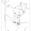
St Kilda, Hirta, Gleann Mor, Structure T


Cellular Building (Period Unassigned)(Possible), Enclosure (Period Unassigned)
Site Name St Kilda, Hirta, Gleann Mor, Structure T
Classification Cellular Building (Period Unassigned)(Possible), Enclosure (Period Unassigned)
Canmore ID 296508
Site Number NA00SE 28
NGR NA 08823 00299
Datum OSGB36 - NGR
Permalink http://canmore.org.uk/site/296508


- Council Western Isles
- Parish Harris
- Former Region Western Isles Islands Area
- Former District Western Isles
- Former County Inverness-shire
Field Visit (10 August 1967)
The descriptions of the 16 'horned' structures identified by Williamson, are confirmed, and in addition the remains of three further chambered structures (but apparently without horn-works) were found during field investigation.
One, 21.0m N of the Amazon's House - NA 0879 0012, appears to be a collapsed 'beehive' dwelling, 3.5m in diameter with much loose stone about it. The entrance is in the NE. Attached to the W and E sides are the footings of a 'beehive' cell, each measuring 2 x 1.0m [NA00SE 25].
Another, 68m N of the Amazon's House - NA 0877 0017, is a mound of earth and stones in which are the remains of a 'beehive' dwelling which has perhaps measured 3m x 2.5m internally. There has been a 'beehive' cell attached to the NW and SE sides, each measuring c 2m x 1.0m. A cleit is built on top of this mound on its SW side [NA00SE 26].
The third - NA 0877 0030, is a mound 1.2m high and measuring 12.6m N-S x 9.0m [NA00SE 27]. An almost circular 'beehive' structure is built into the centre of this mound, and it is almost certain that it is an original dwelling but re-used as a cleit. At least three collapsed cells are attached to this structure, although with its interconnecting passages now filled-in. The 'beehive' structure is 3.8m in diameter, and the cells have been c.2.0m in diameter.
Also associated with this settlement are the outlines of at least 4 small rectangular structures averaging 4m x 1.5m, near to the Amazon's House. One is S of 'horned' structure 'E' (see GP: AO/67/54/4), another 8.0m beyond, and a third 8.0m beyond the latter. The 4th lies 10.0m NW of the 'beehive' site at NA 0877 0030. These would appear to be old shieling bothies.
What appears to be an early hut circle with later structures inserted, is situated on a platform at a higher level than the main shieling complex [NA00SE 28]. At 0882 0030, it comprises a circle of boulders 4.2m in diameter. An elongated chamber has apparently been inserted within on the E side, and there are indications that it had been corbelled in the fashion of the 'beehive' structures. There is also trace of a collapsed cell 2.5m in diameter attached to the S side of the hutand entered from the hut by a narrow passage 0.3m wide and now filled with rubble. The early phase of this site would appear to be possibly contemporary with the huts on the other side of the Bay (see NA00SE 5).
That all these structures in Gleann Mor were used as summer shielings from at least 1697, is discussed elsewhere, but it is also evident that there has been permanent occupation at a much earlier period if one considers the presence of Early IA type hut circles in the area, although these, and to some extent the 'beehive' structures, are comparable with the Neolithic houses on Shetland (C S T Calder 1958).
Visited by OS (J L D) 10 August 1967.
C S T Calder 1958.
Field Visit (3 September 2009)
What may be the remains of a cellular building are situated at the foot of the long steep slope that descends from Mullach Bi. They appear to have been partly remodelled to form a pear-shaped enclosure that narrows towards the N.
Visited by RCAHMS (ARG, SPH) 3 September 2009
Measured Survey (5 September 2009 - 9 September 2009)
RCAHMS surveyed Gleann Mor, Hirta, St Kilda between 5-9 September 2008, using GPS data and ground observation, to produce a site plan at a scale of 1:500 across five survey sheets. These survey drawings were later used as the basis for a site plan redrawn in vector graphics software for publication at a scale of 1:2500 (Gannon and Geddes 2015,84)
Condition Survey (December 2012)
A monitoring survey of twenty structures in Gleann Mor was undertaken in 2012.
NTS 2012

