
Pricing Change
New pricing for orders of material from this site will come into place shortly. Charges for supply of digital images, digitisation on demand, prints and licensing will be altered.
Unst, Hoga Ness


Broch (Iron Age)
Site Name Unst, Hoga Ness
Classification Broch (Iron Age)
Canmore ID 50
Site Number HP50SE 3
NGR HP 5578 0052
Datum OSGB36 - NGR
Permalink http://canmore.org.uk/site/50


- Council Shetland Islands
- Parish Unst
- Former Region Shetland Islands Area
- Former District Shetland
- Former County Shetland
HP50SE 3 5578 0052.
(HP 5578 0054) Brough (NR).
OS 6" map, Shetland, 2nd ed., (1900).
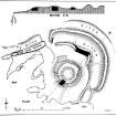
The remains of the Broch of Hoga Ness and its massive defensive works, described by Low (Rev G Low 1879) in 1774 as "razed, but well fortified by two deep ditches and ramparts towards the land."
The general outline of the broch can only be traced with difficulty. It appears to have had an overall diameter of about 60ft, and a wall thickness of roughly 15ft. No indications of an entrance, or cells or passages within the wall can now be observed.
The surrounding defences, although mutilated, can still be clearly followed, as the ramparts are massive and the ditches deep and in places cut through rock. The outer ditch is present in the NE quadrant only. Within it is the outer rampart which curves inwards in the SE and NNW interrupting the inner ditch. A crossing has been left for a way of approach at this NNW point. The inner rampart can be seen, in the NE sector at least, to have consisted of a wall at least 10ft thick. At other points, especially near the crossing in the NNW, both ramparts seem to have been reinforced by a stone facing built with a batter. Between the end of the inner ditch and the edge of the cliff in the SE, an outer and inner rampart are again to be seen, though they are of very much slighter dimensions than elsewhere, and no ditch has been dug between them. A wall has evidently run from the S face of the broch to the edge of the cliff, but it is reduced now to overgrown foundations.
G Low 1879; RCAHMS 1946, visited 1930.
A broch generally as described by RCAHMS. There are traces of the entrance in the SW.
Visited by OS(AA) 8 May 1969
Publication Account (2002)
HP50 6 HOGA NESS ('Belmont')
HP/558005 (visited 7/6/63)
This probable broch on Unst (also known as Belmont) stands at the end of a broad, flat, green turfed peninsula on which is a ruined farm (Ills. 4.1 (top) and 4.2) . The broch itself was a ruined mound in 1774 [1, 151] and it backs on to the steep, rocky shore which is sheer in places, forming cliffs about 20 ft. high; it is defended by extensive outer defences on the landward arc [4, fig. 659].
The building is badly ruined but an overall diameter of about 60 ft. is probable with a wall about 15 ft. thick. The outworks form a massive system of concentric ramparts and ditches (Ill. 4.2). The inner defence is a stone wall or a stone-faced rampart; next to this is a deep ditch followed by a high bank and then an outer ditch. The outer entrance was probably on the western side where the system is interrupted. In the short stretch between this entrance and the sea the second bank is faced inside with masonry built with a marked batter; it is therefore probably a stone-faced bank rather than a wall. The inner ditch seems to be partly rock-cut and the inner wall is about 10 ft. thick.
Sources: 1. Low 1869: 2. Hibbert 1882, 397: 3. OS card HP50 SE 3: 4. RCAHMS 1946, vol. 3, no. 1545.
NMR Photographs: 3P, 1T.
E W MacKie 2002
Note (1 March 2016 - 1 June 2016)
The broch on the low cliff-line of Hoga Ness has been reduced largely to a mound of rubble, but the outer defences are relatively spectacular, comprising an inner wall with two external ditches and a medial rampart drawn in an arc to bar access to the promontory from the N and E. The outer rampart returns and unites with the inner wall around the terminal of the ditch on the E side of an entrance causeway on the NNW, while W of this entrance the wall and the ditch run straight out to the cliff-edge, the ditch exploiting a natural cleft running in from the sea. In behind the wall at this point this W sector of the interior his heavily eroded, and even a conservative restoration of the original edge suggests that the broch stood eccentrically on the E side of the enclosed area. The remains of the inner wall cannot be traced all the way round this eastern side, and the inner ditch, which is about 7m in breadth, stops short of the cliif-edge, though two slighter banks of rubble fill the gap; whether these are blocking an earlier entrance or the ditch is unfinished and these banks are perhaps the remains of an earlier perimeter is unclear. While the outer defences are conventionally interpreted as outworks to the broch, they are certainly not concentric to it and they may once have independently enclosed a much larger area measuring at least 40m deep from NE to SW by 50m transversely (0.15ha).
Information from An Atlas of Hillforts of Great Britain and Ireland – 01 June 2016. Atlas of Hillforts SC4179
Note (March 2017)
Location
On a windswept peninsula on the far southwestern point of the most northerly of the Shetland Islands is Hoga Ness broch, a ruined Iron Age stone tower surrounded by dramatic earthworks. The broch itself survives in good condition, but it has collapsed and has been effected by coastal erosion. Its status as a broch has been questioned in the past, but there are intramural chambers clearly visible, and some of the internal wall faces are visible through the vegetation and rubble. Hoga Ness is one of over 130 brochs in Shetland, and has one of the most impressive defensive ditch and rampart systems of any of these sites.
Razed but well fortified
Hoga Ness Broch is situated on a headland to the west of the farmhouse at Belmont, and is sometimes called Belmont Broch. It dates to some time between 500 BC and 200 AD, and has never been formally excavated. Undoubtedly its most distinctive feature is the massive earthwork defences. These are significant because the purpose of brochs is debated. Were they offensive? Defensive? High status farmhouses? The archaeological remains at Hoga Ness have the potential to help us answer those questions.
The broch was described in 1774 as being 'razed', but well fortified with two very deep ditches and ramparts facing towards the land. At this time the broch seems to have been a grassy mound, and few other details are recorded. Writing in 1822, Hibbert says that the broch tower itself was 60ft (18.2m) in diameter, with walls 15ft (4.5m) thick. Today the outline is obscured by rubble, but it is clear that substantial remains do survive. There are intramural chambers on the S and SE arcs, and a 4m section of the internal wall face is also visible here. The lower courses of the broch likely survive below the ground surface. A small sheep fold stands on the north side of the broch, probably belonging to a nearby ruined farm.
The defensive system is cleverly designed to take advantage of the topography. The massive concentric ramparts and ditches cut off the broch from the land. The inner rampart appears to be stone faced, and next to this is a ditch, and then a high bank and an outer ditch. A section of the inner stone facing is visible on the NE side of the inner rampart. There appears to have been a wall running from the south face of the broch to the cliff, although this has been reduced to its foundations. It is possible that there were other buildings within the broch enclosure, but as it has never been excavated, we cannot say what else was here.
Kirsty Owen - Senior Archaeology Manager

