Accessibility

Font Size

100% 150% 200%

Background Colour

Default Contrast
Close Reset

Wilsontown, Calder Terrace

Workers Row(S) (19th Century) - (20th Century)

Site Name Wilsontown, Calder Terrace

Classification Workers Row(S) (19th Century) - (20th Century)

Alternative Name(s) Wilsontown Ironworks

Canmore ID 99529

Site Number NS95SE 11.07

NGR NS 9507 5517

Datum OSGB36 - NGR

Permalink http://canmore.org.uk/site/99529

Ordnance Survey licence number AC0000807262. All rights reserved.
Canmore Disclaimer. © Bluesky International Limited 2025. Public Sector Viewing Terms

Toggle Aerial | View on large map

Digital Images

Wilsontown, oblique aerial view, taken from the NE, showing the bings of two coal mines at the bottom, and the remains of ironworks, workers' rows, lime kilns, coke ovens and buildings across the remainder of the photograph, including a large area of bell pits in the centre and top left-hand corner.
Wilsontown, oblique aerial view, taken from the NE, showing the bings of two coal mines at the bottom, and the remains of ironworks, workers' rows, lime kilns, coke ovens and buildings across the remainder of the photograph, including a large area of bell pits in the centre and top left-hand corner.Scanned image of oblique aerial view, taken from the NE, showing the bings of two coal mines at the bottom, and the remains of ironworks, workers' rows, lime kilns, coke ovens and buildings across the remainder of the photograph, including a large area of bell pits in the centre and top left-hand corner.Wilsontown, oblique aerial view, taken from the E, showing the remains of workers' rows in the bottom half of the photograph, and the ruins of the public house and shop in the bottom right-hand corner. A large area of bell pits in is visible in the centre right.Wilsontown, oblique aerial view, taken from the SSW, showing the bings of two coal mines at the top of the photograph, and the remains of workers' rows, buildings  and bell pits in the bottom half.Wilsontown, oblique aerial view, taken from the ESE, showing the remains of workers' rows and buildings across the centre of the photograph, lime kilns in the centre left, and a large area of bell pits in the bottom half.Wilsontown, oblique aerial view, taken from the NE, showing the bings of two coal mines at the bottom, and the remains of ironworks, workers' rows, lime kilns, coke ovens and buildings across the remainder of the photograph.Wilsontown, oblique aerial view, taken from the ESE, showing the remains of workers' rows in the centre left of the photograph, and the ruins of the public house and shop, and a large area of bell pits, in the centre.Scanned image of oblique aerial view, taken from the ESE, showing the remains of workers' rows and buildings across the centre of the photograph, lime kilns in the centre left, and a large area of bell pits in the bottom half. Digital image of C41142.Wilsontown, oblique aerial view, taken from the SE, showing the the remains of ironworks, workers' rows, lime kilns, coke ovens, bell pits, and buildings across the photographWilsontown, oblique aerial view, taken from the SW, showing the remains of ironworks, lime kilns, coke ovens and workers' rows in the centre and bottom of the photograph, and a large area of bell pits in the centre and top right-hand corner.Oblique aerial view, taken from the SW, showing the remains of ironworks, lime kilns, coke ovens and workers' rows in the centre and bottom of the photograph, and a large area of bell pits in the centre and top right-hand corner.A reconstruction drawing of the Wilsontown Ironworks by illustrator Michael Blackmore.Wilsontown, oblique aerial view, taken from the ESE, showing the remains of workers' rows in the centre left of the photograph, and the ruined public house and shop, and a large area of bell pits, in the centre.Calder Terrace from W. (copied from postcard)Publication drawing; 'Wilsontown Iron Works, Site plan, compiled from ground survey, aerial photographs and OS map detail'. Wilsontown, oblique aerial view, taken from the E, showing the the remains of workers' rows and buildings, and bell pits, across the bottom half of the photograph.

Administrative Areas

  • Council South Lanarkshire
  • Parish Carnwath
  • Former Region Strathclyde
  • Former District Clydesdale
  • Former County Lanarkshire

Activities

Field Visit (October 1994)

NS95SE 11.07 9507 5517

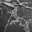
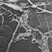
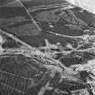
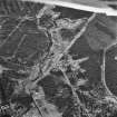
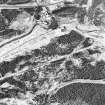
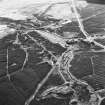
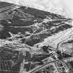
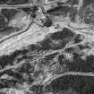
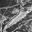
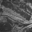
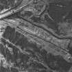
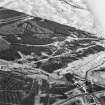
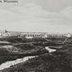
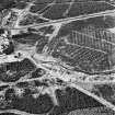
The remains of Calder Terrace (CSW 7019) comprise the footings of three blocks of brick-built cottages, each with a small garden to the ENE, on the E side of the footpath running N through the ruins of Wilsontown Ironworks. Each block measures 33.7m from NNW to SSE by 8.6m transversely, and there were six houses in each block. These houses were constructed about 1910 (Smith 1985), on the site of earlier cottages (CSW 1029) which appear on an 1826 map of the Wilsontown Estate (National Library of Scotland, Map Library).

(CSW 1029, 7019)

Visited by RCAHMS (SDB) October 1994

References

MyCanmore Image Contributions


Contribute an Image

MyCanmore Text Contributions