|
Photographs and Off-line Digital Images |
BS 111/10/2 S |
Historic Scotland Archive Project |
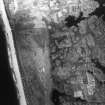
Copy of vertical aerial photograph of Geirinish Machair, South Uist. |
c. 1957 |
Item Level |
|
 |
On-line Digital Images |
SC 1463194 |
Historic Scotland Archive Project |
Copy of vertical aerial photograph of Geirinish Machair, South Uist. |
c. 1957 |
Item Level |
|
 |
On-line Digital Images |
SC 2356325 |
Records of the Ordnance Survey, Southampton, Hampshire, England |
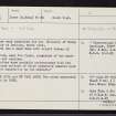
South Uist, Drimore, NF74SE 8, Ordnance Survey index card, page number 1, Recto |
c. 1958 |
Item Level |
|
 |
On-line Digital Images |
SC 2356326 |
Records of the Ordnance Survey, Southampton, Hampshire, England |
South Uist, Drimore, NF74SE 8, Ordnance Survey index card, Verso |
c. 1958 |
Item Level |
|
 |
On-line Digital Images |
SC 2356327 |
Records of the Ordnance Survey, Southampton, Hampshire, England |
South Uist, Drimore, NF74SE 8, Ordnance Survey index card, Recto |
c. 1958 |
Item Level |
|
|
All Other |
551 166/1/1 |
Records of the Ordnance Survey, Southampton, Hampshire, England |
Archaeological site card index ('495' cards) |
1947 |
Sub-Group Level |
|


