
South Uist, Drimore


Hut Circle(S) (Prehistoric)
Site Name South Uist, Drimore
Classification Hut Circle(S) (Prehistoric)
Canmore ID 9948
Site Number NF74SE 8
NGR NF 7559 4080
NGR Description NF 7559 4080 and NF 7562 4081
Datum OSGB36 - NGR
Permalink http://canmore.org.uk/site/9948


- Council Western Isles
- Parish South Uist
- Former Region Western Isles Islands Area
- Former District Western Isles
- Former County Inverness-shire
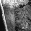
NF74SE 8 7559 4080 and 7562 4081.
Two sites were excavated for the Ministry of Works on the machair at Drimore, South Uist.
The first was a sand dune with slight traces of occupation.
The second, near the first, consisted of two much-robbed stone hut circles.
"Both sites were probably contemporary with the stone roundhouse culture of which extensive remains were found in other excavation on the machair."
J G Scott 1956.
(NF 7560 4072 and NF 7561 4081) Two sites excavated by J G Scott in 1956.
Information from MoPBW to OS.
The first of these occupation sites is at NF 75594080 and is visible only as a partially covered excavation and an accumulation of small loose boulders.
This site has been wrongly positioned by J G Scott and MoPBW. The second site (as planned by MoPBW) is at NF 7562 4081 and has vestiges of two hut-circles, one within the other, outlines by widely spaced boulders.
Surveyed at 1:2500.
Visited by OS (J T T) 20 May 1965.

