
Following the launch of trove.scot in February 2025 we are now planning the retiral of some of our webservices. Canmore will be switched off on 24th June 2025. Information about the closure can be found on the HES website: Retiral of HES web services | Historic Environment Scotland
Scalloway, Harbour


Harbour (19th Century)
Site Name Scalloway, Harbour
Classification Harbour (19th Century)
Alternative Name(s) East Voe Of Scalloway
Canmore ID 986
Site Number HU43NW 21
NGR HU 4039 3913
NGR Description Centred HU 4039 3913
Datum OSGB36 - NGR
Permalink http://canmore.org.uk/site/986


- Council Shetland Islands
- Parish Tingwall
- Former Region Shetland Islands Area
- Former District Shetland
- Former County Shetland
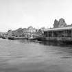
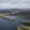
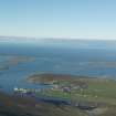
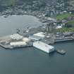
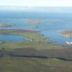
HU43NW 21 centred 4039 3913.
(Location cited as HU 404 392). Scalloway harbour, early 19th century and later. Though the main part of the harbour is modern, there is a small rubble-built section with two slipways. Another, more modern, slipway is at HU 400 393.
J R Hume 1977.

