
Pricing Change
New pricing for orders of material from this site will come into place shortly. Charges for supply of digital images, digitisation on demand, prints and licensing will be altered.
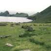
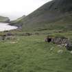
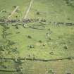
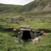
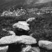
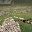
St Kilda, Hirta, Village Bay, House Of The Fairies


Souterrain (Prehistoric), Spearhead (Iron)(Viking)
Site Name St Kilda, Hirta, Village Bay, House Of The Fairies
Classification Souterrain (Prehistoric), Spearhead (Iron)(Viking)
Alternative Name(s) Taigh An T-sithiche
Canmore ID 9697
Site Number NF19NW 7
NGR NF 10019 99409
Datum OSGB36 - NGR
Permalink http://canmore.org.uk/site/9697


- Council Western Isles
- Parish Harris
- Former Region Western Isles Islands Area
- Former District Western Isles
- Former County Inverness-shire
Field Visit (22 July 1924)
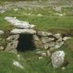
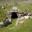
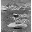
Earth-house, St Kilda.
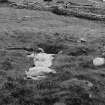
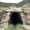
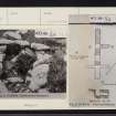
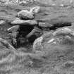
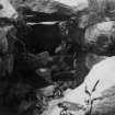
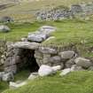
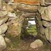
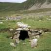
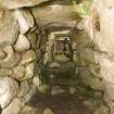
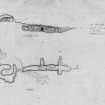
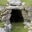
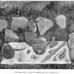
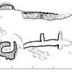
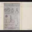
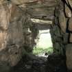
At the western end of the village of St Kilda the ground rises slightly towards the north, and, at a spot about 100 yards north-west of the township, in close proximity to the present burial ground, an earth-house was accidentally discovered about 1844, and opened and examined in 1876 (1). The internal passage, which measures about 34 feet in length by approximately 4 feet in height and 3 ½ feet broad, is roughly lined with stones of various sizes, apparently unworked. There is one side chamber 6 ft. 2 ins. long and evidence of two others. Here and there undressed roofing slabs of about 8 inches in thickness remain in situ. When disclosed in 1876 the floor was found to be of flat stones with a drain below. It was covered with peat ash and soot in a layer about a foot thick, in which were found bones of animals and sea-fowl, burnt limpet shells, “a large number of rude stone implements resembling hatchets and wedges”, “part of a lamp”, and some fragments of coarse pottery (2). (Figs. 74, 75.)
RCAHMS 1928, visited (by Captain Patrick Grant) 22 July 1924.
(1) See Proc. Soc. Ant. Scot., XII., pp. 186-7; cf. also VII., p. 172.
(2) Mr Sands, who had the place opened in 1876, writes: “The men told me that they had often found small vessels of clay in the earth, but had never seen any pottery made, nor heard that it had ever been made in Hirta. Stone lamps are still to be seen above ground, and some old men told me they had often used them when in Berneray and Soa. It is remarkable that all to whom I showed the implements recognised them at a glance…ʻSean lamhog, sean sgian, old axe, old knife’, they said…It is probable that stone implements were used in St Kilda at a very recent date”. (As cited, p. 187.) Mr R. Kearton says the place “had been only partially explored and to a great extent destroyed”. Among other relics he found an iron spear-head (With Nature and a Camera (1897), p.13.
Desk Based Assessment (3 February 1966)
NF 1001 9941) Earth House (NR)
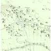
OS 6"map, annotated by J Mathieson (1928)
The earth-house 'Tigh an t'sithiche' (House of the Fairies) was accidentally discovered c 1844, and opened by Sands (J Sands 1878) in 1876, who stated it was 25ft long, 3ft 8ins wide and c 4ft high, with walls of large stones covered by a roof of flat stones and earth. It was further investigated by Kearton (R Kearton 1897) and Mackenzie in 1896, and by Mathieson (J Mathieson 1928) and Cockburn in 1928, the latter excavation proving that the earth-house extended a further 9ft (total 34ft).
Over a foot of peat-ash and soot covered a paved floor (with a drain beneath) in which were found coarse potsherds, hammerstones, shells, animal bones, etc. Finds made by Kearton included a Viking iron spearhead, stone net sinkers (or loom weights), querns, stone lamps, etc. (now in the National Museum of Antiquities of Scotland [NMAS, PSAS 1878, 1897 and 1912] - Accession no. AC 130-2).
Dunlop (M Dunlop 1938) classifies the 'Fairy House' as a 'forecourt monument' Ne/BA, camparable with others in Europe
Information from OS (BRS) 3 February 1966
J Sands 1878; R Kearton 1897; J Mathieson 1928; M Dunlop 1938; Proc Soc Antiq Scot 1878, 1897 and 1912.
Field Visit (7 August 1967)
This souterrain is as described above; but there is no evidence at all of a forecourt (M Dunlop 1938).
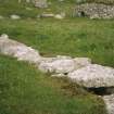
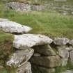
The structure is 9.5m long overall, 3.0m of which is still covered at the rear.
Visited by OS (JLD) 7 August 1967.
Publication Account (1988)
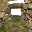
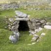
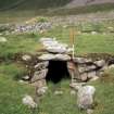
Taigh an t-Sithiche ('House of the Fairies') lies just N of the burial-ground on the strip previously belonging to House 11. Some time after its discovery in about 1844, Sands carried out a detailed investigation. He reported that it was '25 feet (7.62m) long by about 3 feet 8 inches (1.12m) wide and about 4 feet (1.22m) high. The stones with which it is built are large, and the massive walls converge towards the top, so that lintels can be placed on them to form a roof. At a right angle to the house is what I thought to be a passage, but the men declared it to be a crupa or bedplace.' In a deposit of peat- or turf-ash on the floor he found bones of the animals and birds, shells, coarse pottery, and stone implements, some used for pounding and some, as he thought, as axes or cleavers. Under the floor there was a drain. Kearton and Mackenzie also cleared out and 'restored' the structure, finding among other things an iron spearhead. Further excavations were conducted in 1927 by Mathieson and in 1974 by P R Ritchie.
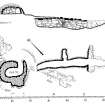
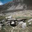
The souterrain survives much as Sands described it: an almost straight subterranean passage aligned NW-SE and 7.6m in length. At about halfway there is a passage branching 1.83m to the NE. The entrance of this shorter passage has a width of only 0.66m and a height of 0.94m, dimensions usually associated with access to wall-beds. The walls are less regular than those of the main passage. Mathieson considered that there were similar opposed lateral chambers towards the SE end, but the evidence for further chambers is inconclusive. It is from this end that the main passage is now entered rather than through the roof as in Sands's day), and the masonry around the opening indicates the likelihood of cross-walls in this position. The walls of the main passage continue for a further 2.5m to the SE, showing that the passage was originally longer in that direction.
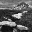
It is also likely that the main passage was longer at the N end where it now finishes with a rough face of earth and stones which lies almost directly beneath the strip boundary. It probably ended beneath, or possibly beyond, Cleit 70 (NF19NW 21.23), which stands on the other side of that boundary, the passage having perhaps been broken into and infilled during the construction of the boundary dyke.
Some of the finds from the excavations have been deposited in the Royal Museum of Scotland, Queen Street, Edinburgh. A few decorated potsherds are considered to be of standard Iron Age type comparable with pottery found at Clettraval and elsewhere in the Hebrides.
G P Stell and M Harmon 1988.
(Sources: J Sands 1878; PSAS 1878; R Kearton 1897; PSAS 1897; PSAS 1912; J Mathieson 1928; RCAHMS 1928; K Williamson and J M Boyd 1960; M Buchanan 1983)
Note (20 September 1989)
This is probably the 'allee converte' (passage grave) noted by Somerville.
T B Somerville 1912. D C Heggie 1981;
Information from J L Davidson 20 September 1989.
Excavation (2004)
NF 100 994 Two trenches, with a combined area of 114m2, were opened in June and July 2004 immediately S and E of the souterrain known as the Fairy House in the Village, in order to assess the extent of earlier investigations and the potential for undisturbed archaeology around the souterrain.
Trench 1, to the S, established the position of an earlier trench, and also the presence of walling and a built platform curving around the southern end of the souterrain, with associated later prehistoric deposits.
Trench 2, to the E, uncovered substantial wall lines and associated deposits, also of late prehistoric date. The wall lines may relate to a previously unknown side passage or chamber to the souterrain, and to a monumental curvilinear structure, possibly an Atlantic roundhouse. The area in the eastern part of the trench had been cultivated in the 19th century, and a very slight stone wall demarcated the cultivated ground from the undisturbed area.
Geophysical survey (resistivity and gradiometer) was conducted over a large transect centred on the burial ground; numerous anomalies, including possible structures, were identified. Topographic survey was carried out over part of the same transect. The work was carried out with the assistance of NTS Work Party volunteers.
Report lodged with the NMRS.
Sponsor: NTS.
M Carruthers, O Lelong, D Maguire and I Shearer 2004
Earth Resistance Survey (2004)
NF 100 994 Resistivity survey.
Report lodged with the NMRS.
Sponsor: NTS.
M Carruthers, O Lelong, D Maguire and I Shearer 2004
Magnetometry (2004)
NF 100 994 Magnetometry survey.
Report lodged with the NMRS.
Sponsor: NTS.
M Carruthers, O Lelong, D Maguire and I Shearer 2004

