
Dalmally, Dalmally Bridge


Road Bridge (18th Century)
Site Name Dalmally, Dalmally Bridge
Classification Road Bridge (18th Century)
Alternative Name(s) Military Road; River Orchy; Strath Of Orchy
Canmore ID 96800
Site Number NN12NE 19
NGR NN 16606 27652
Datum OSGB36 - NGR
Permalink http://canmore.org.uk/site/96800


- Council Argyll And Bute
- Parish Glenorchy And Inishail (Argyll And Bute)
- Former Region Strathclyde
- Former District Argyll And Bute
- Former County Argyll
NN12NE 19 16606 27652
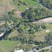
Dalmally Bridge: This three-arched bridge carries the old road from Bonawe via Stronmilchan to Dalmally across the River Orchy at a point about 150m NNW of Glenorchy Church (NN12NE 8). The bridge was constructed by the contractor who had built bridge of Awe, using machinery and centering from the latter, and was completed in 1780.
The S bank of the river is somewhat higher than the N bank; the bridge therefore reaches its highest point above the S arch. Although the rubble masonry has been refaced in the upper parts, the triangular cut-waters remaoin intact and preserve their stepped tops. The overall length of the bridge and approaches is 55m and the distance spanned by the three segmantal arches is 43m. The spans of the individual arches, from N to S, measure 9.2m, 12.9m and 14.8m respectively, and the heights of the arches above water-level measure 4.6m, 5.6m and 6.7m respectively.
The width of the roadway is 4.1m between parapets 0.38m in thickness.
RCAHMS 1975, visited July 1970.
The military road (NN12NE 24, MR 11) traverses the River Orchy on this fine three-span bridge.
W Taylor 1976.
Field Visit (July 1970)
A three arched bridge (Plate 119C) carries the old road from Bonawe via Stronmilchan to Dalmally across the River Orchy at a point about 150 m NNW of Glenorchy Church (No.246). The bridge was constructed by the contractor who had built Bridge of Awe (No. 368), using machinery and centering from the latter, and was completed in 1780.
The S bank of the river is somewhat higher than the N bank; the bridge therefore reaches its highest point above the S arch. Although the rubble masonry has been refaced in the upper parts, the triangular cut-waters remain intact and preserve their stepped tops. The overall length of the bridge and approaches is 55 m and the distance spanned by the three segmental arches is 43 m. The spans of the individual arches, from N to S, measure 9'2 m, 12'9 m and 14.8 m respectively, and the heights of the arches above water-level measure 4.6 m, 5.6 m and6'7 m respectively. The width of the roadway is 4'1 m between parapets 0'38 m in thickness.
South-east of the church, an embankment incorporating three arches carries the road across a backwater of the River Orchy and an area of marshy ground for an overall distance of 63 m. This structure has been extensively rebuilt during the present century; the central arch, which has a span of 8·6 m and a height above water-level of 3'2 m, is now the only part that appears to be of the same date as the larger bridge.
In July 1778, when the construction of Bridge of Awe was under way, the Commissioners of Supply for Argyll petitioned the Forfeited Estates Commissioners for financial assistance to build an additional bridge across the Orchy. The need for this was explained in terms similar to those of the previous petition (cf. No. 368) with the added benefit of facilitating troop-movements during winter. It was stated that the lowest estimate obtained was £650, if the bridge were to be built immediately using wood and machinery from Bridge of Awe; of this sum £300 had been subscribed locally. Construction was completed in August 1780, when the masons received a gift from Glenorchy parish poor-fund, ‘upon finishing Bridge of Urchay’ (SRO, Forfeited Estate Papers, E 728/29/20; New Register House, Glenorchy Parish Register, OPR/512/2, fol.31).
RCAHMS 1975, visited July 1970.

