
Pricing Change
New pricing for orders of material from this site will come into place shortly. Charges for supply of digital images, digitisation on demand, prints and licensing will be altered.
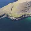
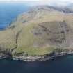
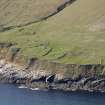
St Kilda, Hirta, Tobar Na Gille


Spring (Period Unassigned)
Site Name St Kilda, Hirta, Tobar Na Gille
Classification Spring (Period Unassigned)
Alternative Name(s) St Brendan's Well
Canmore ID 9651
Site Number NF09NE 6
NGR NF 0977 9840
Datum OSGB36 - NGR
Permalink http://canmore.org.uk/site/9651


- Council Western Isles
- Parish Harris
- Former Region Western Isles Islands Area
- Former District Western Isles
- Former County Inverness-shire
NF09NE 6 0977 9840.
(NF 0977 9840) Tobar na Gille (NAT)
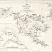
OS 6"map, annotated by J Mathieson (1928)
Tobar na Gille or St Brendan's Well, an open spring, was once used by the St Kildans to seek a favourite wind to take them to Harris.
J Mathieson 1928.
A natural spring: no signs of it ever having been covered.
Visited by OS (J L D) 7 August 1967.
Desk Based Assessment (3 February 1966)
(NF 0977 9840) Tobar na Gille (NAT)
OS 6"map, annotated by J Mathieson (1928)
Tobar na Gille or St Brendan's Well, an open spring, was once used by the St Kildans to seek a favourite wind to take them to Harris
Information from OS (BRS) 3 February 1966
J Mathieson 1928.
Field Visit (7 August 1967)
A natural spring: no signs of it ever having been covered.
Visited by OS (J L D) 7 August 1967.

