
Following the launch of trove.scot in February 2025 we are now planning the retiral of some of our webservices. Canmore will be switched off on 24th June 2025. Information about the closure can be found on the HES website: Retiral of HES web services | Historic Environment Scotland
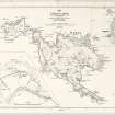
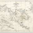
St Kilda, Hirta, St Columba's Church


Chapel (Medieval)
Site Name St Kilda, Hirta, St Columba's Church
Classification Chapel (Medieval)
Alternative Name(s) St Clumba's Chapel
Canmore ID 9647
Site Number NF09NE 2
NGR NF 0984 9914
Datum OSGB36 - NGR
Permalink http://canmore.org.uk/site/9647


- Council Western Isles
- Parish Harris
- Former Region Western Isles Islands Area
- Former District Western Isles
- Former County Inverness-shire
NF09NE 2 0984 9914.
(NF 09849914) St. Columba's Church (NR) (Site of)
[Undated] OS map.
St Columba's church, or chapel, was noticed by Martin in 1698, as a thatched building with graveyard attached (M Martin 1934). Macaulay in 1764 said it had 'neither altar, cross or cell within its precincts' (K Macaulay 1764).
There are now no remains (J Mathieson 1928)
M Martin 1934; K Macaulay 1764; J Mathieson 1928.
No traces remain.
Visited by OS (J L D) 7 August 1967.
Desk Based Assessment (3 February 1966)
St Columba's church, or chapel, was noticed by Martin in 1698, as a thatched building with graveyard attached (M Martin 1934). Macaulay in 1764 said it had 'neither altar, cross or cell within its precincts' (K Macaulay 1764).
There are now no remains (J Mathieson 1928)
Information from OS (BRS) 3 February 1966
M Martin 1934; K Macaulay 1764; J Mathieson 1928.
Field Visit (7 August 1967)
No traces remain.
Visited by OS (J L D) 7 August 1967.
Project (3 September 2007 - 7 September 2007)
NF 101 995 (centred on) Ground Penetrating Radar (GPR) survey was undertaken between 3–7 September 2007 with the aim of identifying any surviving Bronze Age cists. Only a small area could be investigated in the time available and while many anomalies of potential archaeological interest have been detected no responses clearly indicative of cists were noted. A small area of resistance survey was carried out over the suspected location of St Columbus Chapel and the results show a well defined rectilinear response likely to be associated with the Chapel. Unfortunately it would appear that much of the chapel was lost during road construction.
Archive deposited with the Geophysics Unit, Orkney College.
Funder: IWC Media.
Earth Resistance Survey (3 September 2007 - 7 September 2007)
NF 101 995 (centred on) A small area of resistance survey was carried out over the suspected location of St Columbus Chapel and the results show a well defined rectilinear response likely to be associated with the Chapel. Unfortunately it would appear that much of the chapel was lost during road construction.
Archive deposited with the Geophysics Unit, Orkney College.
Funder: IWC Media.
Ground Penetrating Radar (3 September 2007 - 7 September 2007)
NF 101 995 (centred on) Ground Penetrating Radar (GPR) survey was undertaken between 3–7 September 2007 with the aim of identifying any surviving Bronze Age cists. Only a small area could be investigated in the time available and while many anomalies of potential archaeological interest have been detected no responses clearly indicative of cists were noted.
Archive deposited with the Geophysics Unit, Orkney College.
Funder: IWC Media.

