
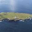
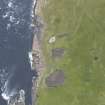
Muckle Skerry, The Kiln


Cairn (Period Unassigned)
Site Name Muckle Skerry, The Kiln
Classification Cairn (Period Unassigned)
Alternative Name(s) Pentland Skerries; Pentland Firth
Canmore ID 9511
Site Number ND47NE 7
NGR ND 4633 7843
Datum OSGB36 - NGR
Permalink http://canmore.org.uk/site/9511


- Council Orkney Islands
- Parish South Ronaldsay
- Former Region Orkney Islands Area
- Former District Orkney
- Former County Orkney
ND47NE 7 4633 7843.
Stone foundations and traces of kitchen midden between the lighthouse enclosure and the pools lying W of it, on Muckle Skerry (information from A Black, lighthouse keeper).
RCAHMS 1946
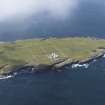
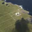
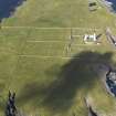
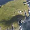
At ND 4633 7843 is a circular turf-covered mound about 12.5m in diameter and 1.0m high. The centre has been mutilated exposing a N-S orientated slab on edge 1.4m long and 0.6 high, about 0.7m S of centre. The slab does not appear to be part of a cist and insufficient remains to identify it as part of a chamber. The mound, however, appears to be the remains of a cairn. Several animal bones can be seen in the centre. Black may also be referring to ND47NE 3.
Surveyed at 1/10,000.
Visited by OS (ISS) 9 May 1973

