
Following the launch of trove.scot in February 2025 we are now planning the retiral of some of our webservices. Canmore will be switched off on 24th June 2025. Information about the closure can be found on the HES website: Retiral of HES web services | Historic Environment Scotland
St Andrews Cathedral, Precinct Wall


Wall (16th Century)
Site Name St Andrews Cathedral, Precinct Wall
Classification Wall (16th Century)
Alternative Name(s) Abbey Wall
Canmore ID 94500
Site Number NO51NW 2.10
NGR NO 51437 16581
NGR Description Centred on NO 51437 16581
Datum OSGB36 - NGR
Permalink http://canmore.org.uk/site/94500


- Council Fife
- Parish St Andrews And St Leonards
- Former Region Fife
- Former District North East Fife
- Former County Fife
NO51NW 2.10 Centred on NO 51437 16581
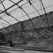
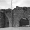
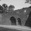
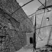
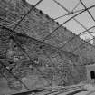
The property of the Priory was likely enclosed from at least the 14th century, and the gatehouse known as 'The Pends' probably belongs to this earlier boundary. The existing wall probably dates to the 16th century when rebuilding work was undertaken throughout the priory and cathedral. According to Hector Boece, Prior John Hepburn, who died in 1522, ordered a wall to be constructed around the priory and its buildings following various repairs. Work on the new wall continued under his successor and nephew Prior Patrick Hepburn, as recorded by an inscription on a wall-tower: [P]RECESSORI[S] OP: POR: HIC PAT; HEPBVRN EXCOLIT EGREGIVS ORBE SALVT. ('Here the excellent Patrick Hepburn in his turn embellishes the work of his predecessor with a tower of 'fens'). (RCAHMS, 1933). In 1683, a total of sixteen towers were arranged along its length; thirteen remain standing and traces of a fourteenth can be traced on the ground. (J Gifford, 1992)
Information from RCAHMS (GJW) 18 April 2002
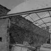
NO 515 165 Proposed remedial works for the stabilisation of the monastic boundary wall in the vicinity of the monastic reredorter were monitored in March 2001. The boundary wall presently defines an area of garden associated with post-monastic occupation during the 18th and 19th centuries. It was found to have slumped outwards due to two factors: the weight of imported soils on its N side, and the wall itself was very poorly founded. A slit trench was excavated against its S face and revealed infilled deposits associated with late monastic activity on the evidence of pottery retrieved. The area also featured at least one stone-capped drain of medieval date, which is probably linked to the great drain which serves the nearby reredorter. The latter was extensively restored and cleared during renovation work by the Marquis of Bute in the later 19th century, and consequently the precise contextual sequence between the fragment of drain identified and the infill deposits discovered in the slit trench was lost. The date of the boundary wall and its associated deposits remains unclear as they respect monastic divisions of the area to the S of the cathedral. Cartographic evidence suggests that this area was a service space, in turn linked with the established route to the harbour.
Sponsor: Historic Scotland
A Radley and G Ewart 2001
Field Visit (24 July 1926)
Abbey Wall and the Pends.
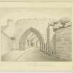
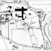
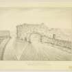
That the property of the Priory was enclosed from at least the 14th century is certain, the gatehouse known as "The Pends" being of that time. The present wall of the precinct, however, with its towers dates only from the early 16th century. Hector Boece, a contemporary writer, states that, after making sundry improvements and repairs in the cathedral and priory buildings, Prior John Hepburn surrounded the whole with a wall having a great number of towers (1). This Hepburn died in 1522, but there is evidence also of at least a contribution to the work by Prior Patrick Hepburn, his nephew and successor. On the first wall-tower north of the Mill Port or "Sea Yett" (SC 1108089), which is now enclosed by the buildings of the gasworks, is the inscription: [P]RECESSORI[S] OP: POR: HICPAT: HEPBVRN EXCOLIT EGREGIVS ORBE SALVT. Professor Rose suggests that an elegiac couplet is intended. This seems very probable and the inscription may then be expanded thus: PRECESSORIS OPVS PORRO HIC PATRICIVSHEPBVRNEXCOLIT EGREGIVS ORBE SALVTIFERO.As a mural tower is in question, and as a common Scots term for such is "round,"(cf. Art. No. 469), the word ORB IS may be taken to have this meaning, so that with SALVTlFER it would be the equivalent of what is also a common description, "a tower of 'fens (defence)". The translation would therefore run: "Here the excellent Patrick Hepburn in his turn embellishes the work of his predecessor with a tower of 'fens". The surname is interrupted by a small shield backed by a crook and bearing the Hepburn arms, below which is the motto, EXPECTO. What now remains of the wall is indicated by a continuous line on the block plan (SC 369410), the course of the missing northern stretch being shown by a broken line. It starts at the 15th century north-eastern buttress of the Cathedral and runs in a north-easterly direction for a distance of II yards up to a round tower, marked No. 1 on Fig. 397. This stretch is apparently of later origin than the remainder. The fact that it has a gate, 9 feet 8 inches wide, with a broad splay both on the jambs and on the semicircular head, suggests that, when it was erected, the precinct had been reduced in area, the Cathedral itself becoming the northern boundary. Over the gateway is a niche withthe lower part of a seated effigy, and on eitherside is a loop. Above the northern loop is an armorial panel, probably a later insertion, bearing the Hepburn arms, the motto ADVITA[M] being carved below the hood. From Tower No.1 the wall originally trended towards the north-west to enclose what is now part of the churchyard, but of this stretch nothing is left but the first nine yards.
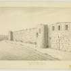
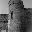
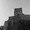
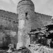
From the other side of the tower the wall runs in a south-easterly direction for a distance of 130 yards, and in this length there are three towers, Nos. 2-4. From Tower No. 4 the wall continues almost due south for a distance of 345 yards and has in that length four towers, Nos. 5-8, the first of these bearing the inscription given above, as well as the "Sea Yett,"as it was known in pre-Reformation times, or "Mill Port," as it was called a century later, on which are the Hepburn arms below a niche and again on a panel at the wall-head. South of this gate are the blocked-up windows and doors of a range of buildings facing the quay of the inner harbour, which were probably warehouses built on the inner side of the wall, and beyond them there is an archway near Tower No.8.From Tower No.8, which was a dovecot, the wall runs westward for 383 yards. In this portion is the "Teinds Gate" [SC 1108090], flanked by Towers Nos. 9 and 10, behind the first of which lay the "Teinds Barns." The main archway of the Teinds Gate, has a smaller archway at one side for pedestrian traffic. The gatehouse above was lit by six oblong chamfered windows looking south. Beyond are the Towers Nos. 11 and 12. A thinner wall is continued westward from Tower No. 12 for a length of 80 yards and then abuts on the last tower of the series, No. 13. But from the former tower the main wall runs northwards for 170 yards, ending at" St. Leonard's House," whence it must have swung inwards, or towards the north-east, to meet the main gatehouse, now known as "The Pends." In all probability, therefore, the wall west of Tower No. 12 represents an extension at the south-western corner of the precinct. Tower No. 13, on which one jamb of a gate can be traced, may thus have been one of the gate-towers, but, from its position, it was more probably an intermediate tower. From it a wall ran northwards behind the houses on the east side of Abbey Street.
If Towers Nos. 8 and 12 be accepted as the southern limits and if the missing northern stretch was as is shown, the precinct had an area of about 30 acres. The wall, which was almost a mile in length, stands to an average height of 20 feet and is over 3 feet thick. Of the sixteen towers counted by Martine previous to 1683, only thirteen remain. Nos. 2-4 are oblong on plan, while the rest are round. All are provided with loops and are decorated with niches, those on Tower No.2, which is known as the "Haunted Tower,' having bases formed of carved stones removed from the Cathedral. On this tower are the Hepburn arms with the initials [PJ LH., for Prior John Hepburn, on the protective hood, while above the hood is a slab carved with a pot of lilies. As already stated, the Hepburn arms are repeated both on the "Sea Yett" and on Tower No.5, but they are also found on the wall between Towers Nos. 10 and 11 and in two places on the stretch between Towers Nos. 11 and 12. It would appear that access to the top part of the towers was obtained from a parapet-walk on the wall. In the case of the "Haunted Tower" (No.2) an upper room was reached from a forest air, while the vaulted apartment below was entered from the ground. The tower next to it (No.3) was found to contain a stair, which apparently served only the upper part. Tower No. 12 also has the remains of a stair.
RCAHMS 1933, visited 24 July 1926.
(1) Scotorum Historice (ed. 1527), lib. vi, fo. cix recto.
Photographic Survey (April 1964)
Photographic survey of the precinct wall, St Andrews Cathedral, Fife, by the Scottish National Buildings Record/Ministry of Works in April 1964 .
Excavation (19 December 2000)
Under the terms of the call off contract Kirkdale Archaeology were asked to excavate a small trench to investigate the footings of the boundary wall of St. Andrews Cathedral, on its' S. side, at Pends Road (NO 515 165). At this point the wall leans inwards (to the N.) alarmingly, and the aim of the exercise was to examine the archaeological implications of carrying out repair work. A substantial culvert heads W. from the Reredorter, some 8m to the E. of the trench, and must run under, or close to, the wall at this point, presumably at least adding to its' instability.
Prior to excavation it had been thought likely that the boundary wall would rest directly on the reredorter culvert, the roof of which is some 70cm below ground level just to the E. of the excavation, so it was a surprise to find that the base of the wall was found only approximately 30cm down in the trench.
Sponsor: Historic Scotland
Kirkdale Archaeology
Excavation (15 March 2000 - 30 March 2000)
NO 515 165 Proposed remedial works for the stabilisation of the monastic boundary wall in the vicinity of the monastic reredorter were monitored in March 2001. The boundary wall presently defines an area of garden associated with post-monastic occupation during the 18th and 19th centuries. It was found to have slumped outwards due to two factors: the weight of imported soils on its N side, and the wall itself was very poorly founded. A slit trench was excavated against its S face and revealed infilled deposits associated with late monastic activity on the evidence of pottery retrieved. The area also featured at least one stone-capped drain of medieval date, which is probably linked to the great drain which serves the nearby reredorter. The latter was extensively restored and cleared during renovation work by the Marquis of Bute in the later 19th century, and consequently the precise contextual sequence between the fragment of drain identified and the infill deposits discovered in the slit trench was lost. The date of the boundary wall and its associated deposits remains unclear as they respect monastic divisions of the area to the S of the cathedral. Cartographic evidence suggests that this area was a service space, in turn linked with the established route to the harbour.
Sponsor: Historic Scotland
A Radley and G Ewart 2001
Kirkdale Archaeology
Excavation (15 March 2001 - 30 April 2001)
The results of the short survey encompass the establishment of the full monastic precinct and claustral arrangements in the form of the latrine block at the end of the East Range. This building was restored during the extensive clearance and restoration programme of the later 19thC under the auspices of the Marquis of Bute. Despite these interventions the cleared drain below and the footprint of the building are considered to be accurate and in situ. However, the investigation of the W end of the drain under the latrine block showed that the drain sequence was not a single phase exercise.
The findings so far suggest that the earliest work was extended or redirected during the later Medieval period , on the basis of the relative scale and quality of the secondary work. This arrangement was complicated later when a smaller, N/S aligned drain(s) was constructed running over the junction of the two sections of earlier, monastic drain. It is not clear whether the earlier conduit was blocked and the later features simply ran across the redundant channel or whether 2 separate channels emptied into the old monastic drain from both N and S. The evidence for the later drain comprised 2 opposing areas of rubble filled trench visible in the N and S sections of the inspection trench.
Elsewhere, the investigation of the boundary wall showed how the wall was built over an earth bank which in turn sealed a further, stone drain, running E/W cut across it, apparently independent of the drains already discovered in Trench 1. The drain was itself cut into a series of possible garden-type soils, pottery evidence from which suggests an early medieval date for its deposition
The small areas examined do therefore suggest that the monastic drainage arrangements, not least its final alignment, are complex and are in turn sealed by a cultivation horizon. This was close to some form of building(s) which were served by at least two drains. The boundary wall construction post-dates the bank and it may be that the latter has some relevance in the later 16th-century siege of the castle. The need for shoring and the presence of sewage prevented a more thorough examination of this sequence, but which covers the occupation of the site from an early Medieval date through to the later years of the 16th century. The re-occupation of the West Range and South Range during the 18th century may be reflected by the N/S drain, but the combination of the Bute works and more recent maintenance, have removed critical contextual evidence, which does doubtless survive beyond the confines of Trench 1.
The separation of bank and garden soil, and the question of residuality for both deposits will prove problematic for environmental analysis.
Sponsor: Historic Scotland
G Ewart & A Radley 2001
Kirkdale Archaeology

