
St John's Point


Chapel (Period Unassigned)(Possible), Cross Slab (Early Medieval)
Site Name St John's Point
Classification Chapel (Period Unassigned)(Possible), Cross Slab (Early Medieval)
Alternative Name(s) Can 028
Canmore ID 9370
Site Number ND37NW 2
NGR ND 3107 7508
Datum OSGB36 - NGR
Permalink http://canmore.org.uk/site/9370


- Council Highland
- Parish Canisbay
- Former Region Highland
- Former District Caithness
- Former County Caithness
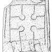
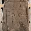
St John’s Point, Canisbay, Caithness, cross-slab
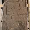
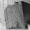
Measurements: H 0.86m, W 0.58m, D 0.05m
Stone type: Old Red Sandstone
Place of discovery: ND 3107 7508
Present location: Caithness Horizons, Thurso.
Evidence for discovery: found during excavations in 1919 by John Nicolson within the remains of a building thought locally to be the site of a chapel. The stone had been re-used as the end slab of a cist just within the doorway in the W gable, together with another fragment, now lost, which was incised with ‘an oblong panel bordered by two parallel lines’.
Present condition: broken but the carving is crisp.
Description
The slab bears a finely incised outline cross with round arm pits, set within an incised frame with the ends of the arms coeval with the frame. Outside the frame at the top right is a segment of a circle, and there are extra lines outside the long sides of the framed cross.
Date: seventh or eighth century.
Compiled by A Ritchie 2016
St John’s Point, Canisbay, Caithness, cross-slab
Measurements: H 0.86m, W 0.58m, D 0.05m
Stone type: Old Red Sandstone
Place of discovery: ND 3107 7508
Present location: Caithness Horizons, Thurso.
Evidence for discovery: found during excavations in 1919 by John Nicolson within the remains of a building thought locally to be the site of a chapel. The stone had been re-used as the end slab of a cist just within the doorway in the W gable, together with another fragment, now lost, which was incised with ‘an oblong panel bordered by two parallel lines’.
Present condition: broken but the carving is crisp.
Description
The slab bears a finely incised outline cross with round arm pits, set within an incised frame with the ends of the arms coeval with the frame. Outside the frame at the top right is a segment of a circle, and there are extra lines outside the long sides of the framed cross.
Date range: seventh or eighth century.
References: Nicolson 1922, 66-7; Blackie & Macaulay 1998, no 15.
Compiled by A Ritchie 2016
ND37NW 2 3107 7508
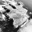
(ND 3107 7508) St John's Chapel (NR) (Site of)
OS 6" map (1960).
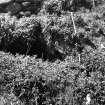
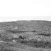
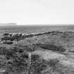
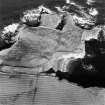
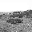
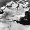
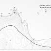
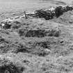
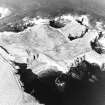
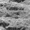
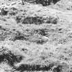
The remains of the alleged Chapel of St John, situated on the inner slopes of the rampart of the promontory fort (ND37SW 1), and partly traversed by a modern wall.
The foundation, partially cleared by Nicolson in 1919, but now (MacDonald and Laing 1969) turf-covered, measure about 24 by 12ft internally, the exterior being flush with the present ground level. It lies E-W and had an entrance in the W end, immediately inside which Nicolson found an oriented "slab-lined grave" one end of which was formed by an incised cross-slab of yellow sandstone, the cross having hollowed 'arm-pits' and a tapering shaft. The slab measured 2ft 10ins long by 1ft 11ins maximum breadth. One of the side slabs, 1ft 8ins in maximum width, bore an oblong panel bordered by two parallel lines. The inside lintel of the door formed part of the cover.
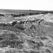
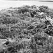
Immediately E of the 'chapel' are the turf-covered footings of a small building, probably about 12ft square, now flush with ground level and lying E-W. To the N is a mounded area roughly 40 yds square running from the rampart of the fort to the cliff edge on the NE in a pronounced curve. The NE sector seems to be artificially scarped but the rest is probably natural. This may be the graveyard in which a seaman was buried about 1850.
Lamb (information from R G Lamb, Birmingham University to OS, 12 January 1972) considers the site to be an eremitical monastery.
Name Book 1873; RCAHMS 1911, visited 1910; J Nicolson 1922; A D S MacDonald and L R Laing 1969.
Dunmey is an alternative name for the promontory on which the chapel lies, and the 'chaplainry of Dunmy' is on record in 1561 and 1566.
Orig Paroch Scot 1855.
Field Visit (14 September 1910)
At the landward end of St John's point, toward the E side of it, and partially traversed by a modern wall, is a foundation, some 32' in length but of indefinate breadth, said to be that of the chapel. In the interior two slabs portrude, which may have formed the ends of a long cist. The building is not correctly orientated, and its designation is doubtful.
Visited by RCAHMS, 14th September 1910.
Field Visit (20 April 1972)
Although still known locally as St John's Chapel, the partly turf-covered footings of this building, exposed in the top of the rampart of the fort (NT37SW 1) may be of more recent origin. Oriented NE-SW it measures 6.6m by 2.2m internally, the NE gable standing to a height of 0.5m and the SW gable to 0.7m. There are traces of the dry-built inner face of the SE wall in the SE corner and the inner face of the NW wall is visible intermittently. The wall thickness cannot be ascertained. There is no entrance in the SW wall as stated by Nicolson, although a different type of masonry in the centre of the wall suggests that the entrance has been blocked up after excavation. There is no trace of a building immediately NE (sic) of the 'chapel' described by MacDonald and Laing (1969). Here, there is merely an irregular slight depression about 2.0m in diameter which could be due to any number of reasons. Apart from the building foundation on the promontory (see ND37NW 1), which may be comparatively recent, there are no traces of any other structures to suggest monastic occupation.
Immediately to the N of the 'chapel' is a raised area about 22m by 35m, which may have been artificially scarpped in the NE as suggested by MacDonald and Laing. There is nothing now to suggest it has been a graveyard.
Surveyed at 1:10,000.
Visited by OS (A A), 20 April 1972.
Field Visit (6 July 1982)
No change to the previous field report.
Visited by OS (J M), 6 July 1982.

